1984 Pacific hurricane season
| |
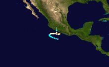
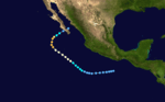
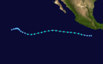
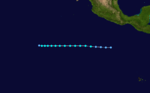
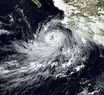
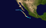
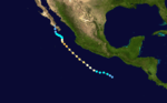
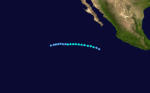
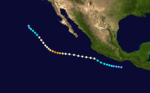
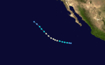
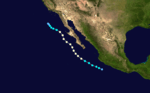
| Season summary map |
| First system formed |
May 17, 1984 |
| Last system dissipated |
November 8, 1984 |
| Strongest storm1 |
Douglas – 145 mph (230 km/h) (1-minute sustained) |
| Total depressions |
26 |
| Total storms |
21 |
| Hurricanes |
13 |
| Major hurricanes (Cat. 3+) |
7 |
| Total fatalities |
0 |
| Total damage |
Unknown |
| 1Strongest storm is determined by lowest pressure |
Pacific hurricane seasons
1982, 1983, 1984, 1985, 1986 |
The 1984 Pacific hurricane season was tied for the fourth most active hurricane season on record. The season produced 26 tropical cyclones, of which 21 developed into named storms; 13 cyclones attained hurricane status, of which three reached major hurricane status. The season officially started on May 15, 1984 in the eastern Pacific, and June 1, 1984 in the central Pacific, and lasted until November 30, 1984. These dates conventionally delimit the period of each year when the vast majority tropical cyclones form in the northeastern Pacific Ocean. The strongest hurricane of the season was Hurricane Douglas, which attained Category 4 status on the Saffir-Simpson Hurricane Scale in the open Pacific.
Only four tropical systems made landfall during the season. In September, Hurricane Norbert took an erratic path before making landfall on Baja California as a tropical storm, bringing flooding rains. Hurricane Odile also made landfall on Mexico during September as a tropical storm, killing 21 at sea and severely damaging crops. Additionally, Hurricanes Genevieve and Polo struck Mexico as tropical depressions. Hurricane Douglas also threatened Hawaii.
Seasonal summary
There were 18 tropical storms in the Eastern Pacific Hurricane Center’s (EPHC) area of responsibility (AOR) this season. Twelve became hurricanes. Of those, six became major hurricanes by reaching Category 3 intensity or higher on the Saffir-Simpson Hurricane Scale. In the Central Pacific Hurricane Center’s (CPHC) AOR, there was a major hurricane and two tropical storms. There was one tropical depression that did not strengthen into a storm.
The first storm of the season formed on May 17 and the last storm disspted on November 5, spanning 173 days. While this was much shorter than 1983, it was still two weeks longer than the 10 year average. During the season, there were a total of 1187 storm hours and 1048 hurricane hours, both of which were well above normal. A total of 585 advisories were issued by the EPHC, nearly 200 above normal.
Storms
Tropical Storm Alma
| Tropical storm (SSHWS) |
|
|
| Duration |
May 17 – May 21 |
| Peak intensity |
60 mph (95 km/h) (1-min) |
Alma, a short-lived storm, developed from a tropical disturbance that later strengthened into Tropical Depression One-E on May 17. It continued strengthening until May 19, when it strengthened into Tropical Storm Alma, the first tropical cyclone and named storm of the season. Alma hit its peak intensity of a strong tropical storm of 60 mph (95 km/h) later that day. Moving due west, On May 21, it was downgraded into a depression. Later that same day, Alma was declared dissipated as it degenerated into an open trough.[1][2]
Hurricane Boris
| Category 1 hurricane (SSHWS) |
|
|
| Duration |
May 28 – June 18 |
| Peak intensity |
75 mph (120 km/h) (1-min) |
On May 28, a tropical depression formed 345 mi (555 km) south of the Gulf of Tehuantepec. Moving west, the storm was located underneath 88 °F (31 °C) waters.[1] The depression strengthened into a tropical storm the next day.[2] On May 30, Boris strengthened into a hurricane, the first of the season, and reached its peak intensity with 75 mph (121 km/h) winds.[1] The next day the hurricane weakened into a tropical storm and began executing a loop in response to a building ridge. Boris soon weakened to a tropical depression. After traversing cooler waters of 78 °F (26 °C), the depression dissipated into a remnant low on June 5.[1] However, on June 12, its remnants redeveloped into a tropical storm.[1] In response to an upper-level trough, Boris began to move to the north. However the trough weakened and Boris subsequently began moving to the west, over cooler waters, and dissipated on June 18.[1]
Hurricane Cristina
| Category 2 hurricane (SSHWS) |
|
|
| Duration |
June 17 – June 26 |
| Peak intensity |
105 mph (165 km/h) (1-min) |
Hurricane Cristina formed from a tropical disturbance 345 mi (555 km) southwest of Acapulco on June 17. Moving west due to a combination of a weak westerly-moving upper-level low and a subtropical ridge, the storm intensified into a tropical storm on the same day. Cristina continued to gradually intensify before reaching peak intensity with 105 mph (170 km/h) winds on June 19, a mid-level Category 2 hurricane. The hurricane began moving to the northwest in response to a high-pressure area and weakened into a tropical storm on June 22. Cristina intensified to become a hurricane for a second time on June 24.[2] Cristina eventually dissipated June 26[1] after bring high clouds to the Baja California Peninsula for a few days.[3]
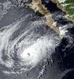
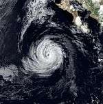
Hurricane Douglas
| Category 4 hurricane (SSHWS) |
|
|
| Duration |
June 25 – July 6 |
| Peak intensity |
145 mph (230 km/h) (1-min) |
A disturbance off the coast of Mexico had no significant convection until June 25, when it strengthened into Tropical Depression Four-E. As it strengthened into a Tropical Storm, it received the name Douglas. It strengthened into a hurricane the next day. It hit its peak intensity of a Category Four on the SSHS on June 28. The next day, Douglas weakened into a category 3, then a category 2 late the same day. It later weakened into a Tropical Storm on June 5, then on June 6, the storm met its demise as it dissipated. Douglas was the strongest storm of the season. Its remnants brought rain to Maui and the Big Island.
Hurricane Elida
| Category 4 hurricane (SSHWS) |
|
|
| Duration |
June 28 – July 9 |
| Peak intensity |
130 mph (215 km/h) (1-min) |
A tropical disturbance developed roughly 350 mi (565 km) south of Salina Cruz. Several hundred miles southwest of Acapulco, the disturbance was upgraded into a tropical depression on June 28. Moving northwestward, the depression was upgraded into Tropical Storm Elida 24 hours later. Rapidly intensifying, Elida eventually peaked as a powerful category 4 hurricane. Shortly after its peak, Elida moved over 76 °F (24 °C) waters as its motion slowed. Hurricane Elida later began to turn southwest, then south, and then east as it interacted with Hurricane Fausto and Genevieve. By that time, Elida was only a tropical depression. On July 9, Elida dissipated as a tropical cyclone.
Tropical Depression Six-E
| Tropical depression (SSHWS) |
|
|
| Duration |
June 30 – July 2 |
| Peak intensity |
35 mph (55 km/h) (1-min) |
This tropical depression failed to develop.
Hurricane Fausto
| Category 2 hurricane (SSHWS) |
|
|
| Duration |
July 3 – July 10 |
| Peak intensity |
110 mph (175 km/h) (1-min) |
A weak tropical disturbance entered the Pacific on July 1. Moving over a pocket of 90 °F (32 °C) waters, it rapidly intensified into a tropical storm on July 3. Fausto slowly turned northwest into an area between two strong troughs. Late on July 8, Fausto reached hurricane intensity. Continuing to rapidly intensify, Fuasto attained peak intensity of 110 mph (175 km/h) 686 km (426 mi) south of La Paz. Hurricane Fuasto continued to move northwest, weakening as it encountered progressively cooler waters. During the afternoon of July 8, the EPHC downgraded Fausto into a tropical storm. Fuasto turned west on July 9 in response to a ridge north of the cyclone. Shortly thereafter, Fuasto was downgraded into a tropical depression, and the system dissipated the next day.[1] Fausto brought high clouds to southern Baja California Sur for four days.[3]
Hurricane Genevieve
| Category 3 hurricane (SSHWS) |
|
|
| Duration |
July 7 – July 14 |
| Peak intensity |
115 mph (185 km/h) (1-min) |
Genevieve was a major hurricane that moved northwestward off the west coast of Mexico, existing from July 7–14, when it dissipated over the southern Baja California peninsula.
Tropical Depression Nine-E
| Tropical depression (SSHWS) |
|
|
| Duration |
July 24 – July 25 |
| Peak intensity |
30 mph (45 km/h) (1-min) |
This tropical depression moved north-northwest out of the Intertropical Convergence Zone (ITCZ).
Tropical Storm Hernan
| Tropical storm (SSHWS) |
|
|
| Duration |
July 27 – August 1 |
| Peak intensity |
50 mph (85 km/h) (1-min) |
Hernan was a short-lived and weak tropical storm which had no effects on land.
Hurricane Iselle
| Category 4 hurricane (SSHWS) |
|
|
| Duration |
August 3 – August 12 |
| Peak intensity |
130 mph (215 km/h) (1-min) |
Iselle was a powerful category 4 hurricane, but the storm never affected any land.
Tropical Storm Julio
| Tropical storm (SSHWS) |
|
|
| Duration |
August 15 – August 20 |
| Peak intensity |
65 mph (100 km/h) (1-min) |
Julio was a storm which did not have any impacts on land.
Hurricane Keli
| Category 3 hurricane (SSHWS) |
|
|
| Duration |
August 16 – August 22 |
| Peak intensity |
115 mph (185 km/h) (1-min) |
Hurricane Keli was a major hurricane that threatened Johnston Atoll enough to prompt an evacuation. However, intense shear disintegrated the cyclone. There was no damage.
Tropical Storm Kenna
| Tropical storm (SSHWS) |
|
|
| Duration |
August 16 – August 21 |
| Peak intensity |
60 mph (95 km/h) (1-min) |
Kenna was a weak tropical storm which did not affect land.
Tropical Storm Lala
| Tropical storm (SSHWS) |
|
|
| Duration |
August 23 – September 2 |
| Peak intensity |
50 mph (85 km/h) (1-min) |
Tropical Depression Fourteen-E crossed the 140 longitude, and became Tropical Storm Lala. Lala, along with Iniki of 1992, Li of 1994, Lana of 2009, Ela of 2015 & Ulika of 2016 are the only six Tropical Storms to be named in the Central Pacfic, but form in the Eastern Pacific.
Hurricane Lowell
| Category 1 hurricane (SSHWS) |
|
|
| Duration |
August 26 – August 30 |
| Peak intensity |
85 mph (140 km/h) (1-min) |
Lowell was a hurricane that did not impact land.
Tropical Storm Moke
| Tropical storm (SSHWS) |
|
|
| Duration |
September 4 – September 5 |
| Peak intensity |
50 mph (85 km/h) (1-min) |
Moke had uncertain beginnings, as it developed from a cold-core low that eventually became a tropical storm just east of the dateline. It passed close to Kure Atoll, encountered shear, and lost tropical characteristics.
Hurricane Marie
| Category 1 hurricane (SSHWS) |
|
|
| Duration |
September 5 – September 11 |
| Peak intensity |
90 mph (150 km/h) (1-min) |
Hurricane Marie dissipated off the coast of Baja California. Its remnants recurved and brought minor levels of rain to California.
Tropical Depression Seventeen-E
| Tropical depression (SSHWS) |
|
|
| Duration |
September 11 – September 12 |
| Peak intensity |
35 mph (55 km/h) (1-min) |
This tropical depression formed in the Gulf of Tehuantepec.
Tropical Depression Eighteen-E
| Tropical depression (SSHWS) |
|
|
| Duration |
September 14 – September 15 |
| Peak intensity |
35 mph (55 km/h) (1-min) |
This tropical depression formed along the coast near Zihuatanejo, Mexico from the remnants of Edouard.
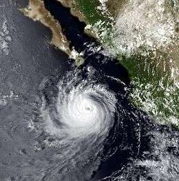
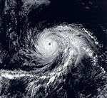
Hurricane Norbert
| Category 4 hurricane (SSHWS) |
|
|
| Duration |
September 14 – September 26 |
| Peak intensity |
130 mph (215 km/h) (1-min) |
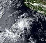
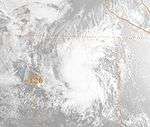
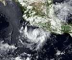
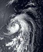
A tropical depression first developed on September 14 over the Pacific Ocean west of the Mexican coast. Six hours later, the depression intensified into Tropical Storm Norbert. Norbert reached hurricane status on September 16, and shortly thereafter Norbert became a hurricane. On September 17, Norbert was upgraded to a major hurricane (Category 3 or higher). Meanwhile, Norbert meandered.[2] At 0000 UTC, September 21, Norbert reached its peak intensity of 135 mph (217 km/h). Shortly after its peak, Hurricane Norbert began to turn to the northwest.[1]
Norbert fluctuated in intensity over the next few days.[2] On September 23, a Hurricane Hunter aircraft intercepted Norbert,[1] marking the first time that the core of a hurricane was completely mapped in 3-D. The aircraft was also equipped with Doppler weather radar.[4] Although the hurricane's motion accelerated, by September 25, Norbert was only a Category 2 hurricane.[2] After weakening back into a tropical storm early on September 26 and subsequently ashore near Point Abreojos in the central portion of the Baja California Peninsula while a high-end tropical storm. Norbert eventually became one of the eight tropical cyclones to survive into Arizona.[5]
Described as "big and ugly" by meteorologists,[6] a combination of Norbert and several other storms left many people without a home and hotels nearly empty.[7] Scattered and light rainfall fell across portions of Baja California Norte and Sonora[8] Sustained winds of 20 to 30 mph (30 to 50 km/h) were recorded in the Tucson metropolitan area, but only moderate rainfall occurred throughout south-central to northeast Arizona.[9]
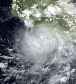
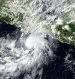
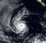
Hurricane Odile
| Category 2 hurricane (SSHWS) |
|
|
| Duration |
September 17 – September 23 |
| Peak intensity |
105 mph (165 km/h) (1-min) |
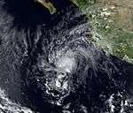
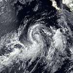
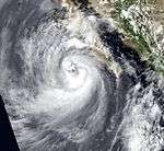
A tropical disturbance was noted about 150 mi (240 km) south of Acapulco on September 16 and was classified as a tropical depression the next day. About 24 hours after developing into a tropical cyclone, the depression was upgraded to Tropical Storm Odile. By the afternoon of September 19, Odile became a hurricane while meandering south of the Mexican coast.[1]
Late on September 21, Hurricane Odile reached its peak intensity of 105 mph (165 km/h). While maintaining peak intensity for a half of a day, the cyclone began to turn more northwestward and weaken over cooler waters.[1] The hurricane weakened to tropical storm status while approaching the coast of Mexico. By late on September 22, Odile made landfall about 50 miles (80 km) northwest of Zihuatanejo, as a weak tropical storm, with winds of 50 mph (80 km/h). Less than six hours later, Odile became an extratropical cyclone, which was at 0000 UTC on September 23. The remnants of Odile moved northwest to the east of Manzanillo before weakening as it re-curved towards Texas.[1][10]
Heavy rainfall was recorded across Southern Mexico, with the maximum rainfall totals in Costa Azul and Acapulco,.[10] Due to an extended period of heavy rainfall, flooding resulted in damage to about 900 homes, inundation of about 30 miles (48 km) of highways, triggered an evacuation of 7,000 people, and left 20,000 families without any water service.[11] About eighty percent of the crops in the state of Guerrero were damaged. Commercial flights in Acapulco were suspended for two daybecuase airline terminal was flooded by more than 3 ft (910 mm) of water. In addition, Hurricane Odile knocked down two high-tension towers.[11] Overall, the hurricane killed 40 people, and hundreds more were missing,[12] and left thousands homeless.[11]
Hurricane Polo
| Category 3 hurricane (SSHWS) |
|
|
| Duration |
September 26 – October 3 |
| Peak intensity |
115 mph (185 km/h) (1-min) |
As a tropical depression, Polo made landfall in the extreme southern part of the Baja California Peninsula on October 3.
Tropical Storm Rachel
| Tropical storm (SSHWS) |
|
|
| Duration |
October 7 – October 16 |
| Peak intensity |
65 mph (100 km/h) (1-min) |
A tropical depression formed on October 7, several hundred miles south of Mexico. It was upgraded to Tropical Storm Rachel on October 9, as it continued westward into the open waters of the Pacific Ocean. Rachel was downgraded to a tropical depression on October 11, as it began to turn northwest. The depression then dissipated in open waters on October 16.
Tropical Storm Simon
| Tropical storm (SSHWS) |
|
|
| Duration |
October 31 – November 8 |
| Peak intensity |
65 mph (100 km/h) (1-min) |
Simon was a moderately strong tropical storm which did not affect land.
Tropical Depression Twenty-Four-E
| Tropical depression (SSHWS) |
|
|
| Duration |
November 5 – November 5 |
| Peak intensity |
35 mph (55 km/h) (1-min) |
This tropical depression quickly formed and dissipated over cool water.
Season effects
Storm names
The following names were used for named storms that formed in the eastern Pacific in 1984. No names were retired, so the list of names was used again in the 1990 season. Names that were not assigned are marked in gray.
- Alma
- Boris
- Cristina
- Douglas
- Elida
- Fausto
- Genevieve
|
- Hernan
- Iselle
- Julio
- Kenna
- Lowell
- Marie
- Norbert
|
- Odile
- Polo
- Rachel
- Simon
-
Trudy (unused)
-
Vance (unused)
-
Wallis (unused)
|
Three names from the Central Pacific list were used - Keli, Lala, and Moke. This was the first usage for all of these names.
See also
References
- 1 2 3 4 5 6 7 8 9 10 11 12 13 Gunther, Emil B.; Cross, Robert L. (August 1985). "Eastern North Pacific Tropical Cyclones of 1984". Monthly Weather Review. 113 (8): 1393–1410. Bibcode:1985MWRv..113.1393G. doi:10.1175/1520-0493(1985)113<1393:ENPTCO>2.0.CO;2. ISSN 1520-0493. Retrieved December 17, 2011.
- 1 2 3 4 5 6 National Hurricane Center; Hurricane Research Division; Central Pacific Hurricane Center. "The Northeast and North Central Pacific hurricane database 1949–2015". United States National Oceanic and Atmospheric Administration's National Weather Service. A guide on how to read the database is available here.
- 1 2 Garcia, Perez; A.V. Douglas (July 24, 1989). "On the Satus cover" (PDF). Stereotactic and functional neurosurgery. 83 (5–6): 219–234. doi:10.1159/000090433. PMID 16374074. Retrieved July 26, 2012.
- ↑ Frank D. Marks; Rober A. Houze; John F. Gamache (September 9, 1991). "Dual-Aircraft Investigation of the inner Core of Hurricane Norbert. Part I: Kinematic Structure" (PDF). American Meteorological Society. Journal of Atmospheric Sciences, vol. 49, Issue 191 pp.919-942. Retrieved September 11, 2011.
- ↑ National Weather Service, Tucson Regional Office. "Tropical cyclones in Arizona". Retrieved October 11, 2011.
- ↑ "Hurricane big and ugly, shipping warned". Free Lawrence Star. September 24, 1984. Retrieved September 11, 2011.
- ↑ "Storm batters Mexico resort". The Spokes-Review. September 24, 1984. Retrieved September 11, 2011.
- ↑ "Hurricane Norbert – July 24–27, 1984". Hydrometeorological Prediction Center. Retrieved September 10, 2011.
- ↑ National Weather Service, Tucson Regional Office. "Hurricane Norbert 1984". Retrieved September 11, 2011.
- 1 2 Roth, David M. (April 2, 2007). "Hurricane Odile- September 16-24, 1984". National Oceanic and Atmospheric Administration. Hydrometeorological Prediction Center. Retrieved December 17, 2011.
- 1 2 3 "Storms leave thousands homeless across Mexico". Lakeland Ledger. Associated Press. September 25, 1984. Retrieved December 17, 2011.
- ↑ "Damaging hurricanes in Central America, Caribbean, USA and Mexico". El Universal. EFE. August 21, 2007. Retrieved June 16, 2012.
External links
|
|---|
|
| |
|
-
 Book Book
-
 Category Category
-
 Portal Portal
-
 WikiProject WikiProject
-
 Commons Commons
|


.JPG)