2015 Kokang offensive
| 2015 Kokang offensive | |||||||||
|---|---|---|---|---|---|---|---|---|---|
| Part of Internal conflict in Myanmar | |||||||||
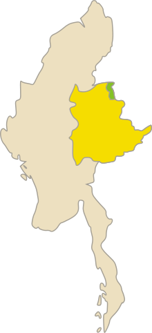 Location of the Kokang Self-Administered Zone (green) within Shan State (yellow). | |||||||||
| |||||||||
| Belligerents | |||||||||
|
| |||||||||
| Commanders and leaders | |||||||||
|
|
| ||||||||
| Strength | |||||||||
| Unknown | Initial 1,000; later 3,000-4,000 total with reinforcements[1] | ||||||||
| Casualties and losses | |||||||||
| ~126 killed and 359 wounded[2] | ~90 killed and 300 wounded[2][3][4][5] | ||||||||
|
~215 killed in total Over 50,000 civilians displaced | |||||||||
The 2015 Kokang offensive was military operations launched by the Myanmar Army in 2015 in Kokang in northern Shan State, Myanmar (Burma). Several clashes between the Myanmar Army and Myanmar National Democratic Alliance Army had taken place from February to May 2015.
Background
The Myanmar National Democratic Alliance Army (MNDAA) was formerly part of the Communist Party (Burma) and became the first of about a dozen factions to sign a bilateral cease-fire agreement with the then-military government after the group broke apart in 1989.[6] The Kokang Special Region and MNDAA, under the leadership of Pheung Kya-shin, enjoyed ceasefire with the government from 1989 to 2009.
This calm faltered in 2009 when MNDAA came under pressure to transform into a paramilitary Border Guard Force under the control of the Burmese Army. The MNDAA resisted this move, and hostilities from the army increased, purportedly due to MNDAA links with the drug trade.[7] After the 2009 Kokang incident, Pheung himself was driven out by his competitors from within the army and had fled after a warrant was issued for his arrest.
In December 2014, he told Chinese state media in an interview that the MNDAA was trying to regain some territories it lost in 2009.[8][9]
Re-insurgence
After six years of relative calm, fighting was first reported on 9 February 2015 in Laukkaing Township, Kokang Self-Administered Zone in the northern part of Shan state near Sino-Burmese border. The MNDAA troops, who were trying to retake the Kokang self-administered zone, had attacked Burmese army outposts near the town of Mawhtike on 9 February. Further fighting broke out in Tashwehtan, northwest of Laukkai in the morning of 10 February as Burmese army reinforcements arrived in the region.[6][7]
According to state-run newspaper, Global New Light of Myanmar, 200 Kokang insurgents, as opposed to government-loyal Kokang units, attacked an army military base in the Konkyan Township and shelled the army headquarters on 12 February.[10] Myanmar government announced state of emergency on 17 February.[11]
The MNDAA's allies, the Arakan Army (AA) and Ta’ang National Liberation Army (TNLA) were also fighting alongside the MNDAA. Some sources indicated that the Kachin Independence Army (KIA), United Wa State Army and National Democratic Alliance Army[12] were also involved, but KIA denied its involvement.[7][8][13][14][15][16]
After fighting for four months, Myanmar army troops had seized the last stronghold of MNDAA on 14 May 2015.[17] MNDAA declared a unilateral ceasefire on 11 June and Myanmar government offered a peace deal on 22 June 2015.[18][5]
The MNDAA is thought to be under the command of former leader Pheung Kya-shin, who was ousted from his position by a government-backed Kokang faction in 2009 and has since lived in relative obscurity in China.[16][19]
Civilians and refugees
The conflict had forced 40,000 to 50,000 civilians to flee their homes and seek shelter on the Chinese side of the border while some 4,500 others had taken refuge in Lashio, Shan State.[10][19][20][21]
A convoy of the Myanmar Red Cross Society, clearly marked with red cross insignia which was carrying its staff and at least two journalists, was attacked by MNDAA troops on 17 February after an aid mission in Laukkai township. One member of the convoy died and one was injured due to the attack.[22][23] But MNDAA spokesperson, Tun Myat Lin, denied the charge.[24]
On 13 March, a bomb hit a sugarcane field in Lincang, China killing four people and wounding nine others with Chinese government demanding a full investigation.[25][26] Burmese government issued a formal apology to China acknowledging the cross-border bombing.[27] Another five people from Lincang were injured on 14 May.[28][29]
Child soldiers
It was reported by Reuters in March 2015 that the MNDAA uses child soldiers in the conflict.[30]
Foreign support
Burmese Minister for Information Ye Htut called on Chinese government to rein in any local officials who might be helping the group on their side of the border.[15] According to Military intelligence of Myanmar, MNDAA forces are being supported by former Chinese soldiers recruited as mercenaries.[3][31] However, Chinese government has stated that it did not give military assistance to MNDAA and TNLA spokesman rejected the assertions by the Burmese government.[6]
References
- ↑ "47 Govt Troops Killed, Tens of Thousands Flee Heavy Fighting in Shan State". irrawaddy.org.
- 1 2 "Myanmar says 126 soldiers have been killed in fight with Kokang army". Xinhua News Agency. 19 April 2015.
- 1 2 ABC News. "Myanmar Says Kokang Rebels on the Run Despite Allies' Help". ABC News.
- ↑ "Situation in Myanmar's Kokang region calm down gradually: officer". GlobalPost.
- 1 2 "Rebels declare 'unilateral ceasefire' with Myanmar army". Mizzima.
- 1 2 3 "Myanmar Kokang Rebels Deny Receiving Chinese Weapons". Radio Free Asia.
- 1 2 3 NANG MYA NADI (10 February 2015). "Kokang enlist allies' help in fight against Burma army". dvb.no.
- 1 2 "Myanmar Army Troops Recover Bodies of 13 Rebels in Renewed Clash". irrawaddy.org.
- ↑ "Thousands Reportedly Cross Into China to Flee Fighting, Airstrikes in Shan State". irrawaddy.org.
- 1 2 DVB (13 February 2015), "47 Burmese soldiers killed in Kokang conflict: state media", dvb.no
- ↑ 刘珊珊. "Myanmar announces extension of state of emergency in Kokang region". chinadaily.com.cn.
- ↑ Thida Linn. "Military says ethnic groups supplying Kokang rebels". Eleven Myanmar.
- ↑ The Myanmar Times. "Ethnic allies join Kokang fight". mmtimes.com.
- ↑ Thida Linn. "Military chief discusses clashes with ethnic groups". Eleven Myanmar.
- 1 2 AFP. "Myanmar airstrikes hit Kokang rebels". mizzima.com. Archived from the original on 10 March 2015.
- 1 2 NANG MYA NADI (16 February 2015). "Burma army claims 26 Kokang rebels killed". dvb.no.
- ↑ "Government troops 'seize last stronghold of Kokang rebels'". Mizzima.
- ↑ "Government offers peace deal to Kokang Rebels". Mizzima.
- 1 2 "Tens of thousands flee war, airstrikes in Kokang region". DVB Multimedia Group. Retrieved 31 March 2015.
- ↑ "By truck, by bike, by foot – the exodus from Laogai". DVB Multimedia Group. Retrieved 31 March 2015.
- ↑ "Thousands Displaced by Kokang Fighting Arrive in Lashio". irrawaddy.org.
- ↑ "Red Cross Convoy Ambushed Near Laukkai". The Irrawaddy. 17 February 2015. Retrieved 18 February 2015.
- ↑ Aid worker dies from Kokang convoy attack wounds | Mizzima
- ↑ "Myanmar, Kokang Rebels Trade Accusations Over Red Cross Attack". VOA. Retrieved 23 February 2015.
- ↑ "China threatens 'decisive' response after Myanmar bombing". Yahoo News Canada. 15 March 2015.
- ↑ "Myanmar's Air Force Back in Kokang Amid After Chinese Ire Over Border Bombing". irrawaddy.org.
- ↑ Lun Min Maung , Ye Mon (6 April 2015). "Myanmar apologises to China over cross-border bombing". The Myanmar Times. Retrieved 6 April 2015.
- ↑ "Chinese villagers injured by Myanmar shell fire". Mizzima.
- ↑ "Army Chief blames MNDAA for shelling inside China". Mizzima.
- ↑ Stringer China (20 March 2015). "Myanmar's China-backed rebels". Reuters. Retrieved 20 March 2015.
- ↑ Post Publishing PCL. "Myanmar points finger in Kokang - Bangkok Post: news". http://www.bangkokpost.com. External link in
|work=(help)
External links
Coordinates: 23°41′30″N 98°45′45″E / 23.69167°N 98.76250°E