501 Queen
| 501 Queen | |||||||||||||||||||||||||||||||||||||||||||||||||||||||||||||||||||||||||||||||||||||||||||||||||||||||||||||||||||||||||||||||||||||||||||||||||||||||||||||||||||||||||||||||||||||||||||||||||||||||||||||||||||||||||||||||||||||||||||||||||||||||||||||||||||||||||||||||||||||||||||||||||||||||||||||||||||||||||||||||||||||||||||||||||||||||||||||||||||||||||||||||||||||||||||||||||||||||||||||||||||||||||||||||||||||||||||||||||||||||||||||||||||||||||||||||||||||||||||||||||||||||||||||||||||||||||||||||||||||||||||||||||||||||||||||||||||||||||||||||||||||||||||||||||||||||||||||||||||||||||||||||||||||||||||||||||||||||||||||||||||||||||||||||||||||||||||||||||||||||||||||||||||||||||||||||||||||||||||||||||||||||||||||||||||||||||||||||||||||||||||||||||||||||||
|---|---|---|---|---|---|---|---|---|---|---|---|---|---|---|---|---|---|---|---|---|---|---|---|---|---|---|---|---|---|---|---|---|---|---|---|---|---|---|---|---|---|---|---|---|---|---|---|---|---|---|---|---|---|---|---|---|---|---|---|---|---|---|---|---|---|---|---|---|---|---|---|---|---|---|---|---|---|---|---|---|---|---|---|---|---|---|---|---|---|---|---|---|---|---|---|---|---|---|---|---|---|---|---|---|---|---|---|---|---|---|---|---|---|---|---|---|---|---|---|---|---|---|---|---|---|---|---|---|---|---|---|---|---|---|---|---|---|---|---|---|---|---|---|---|---|---|---|---|---|---|---|---|---|---|---|---|---|---|---|---|---|---|---|---|---|---|---|---|---|---|---|---|---|---|---|---|---|---|---|---|---|---|---|---|---|---|---|---|---|---|---|---|---|---|---|---|---|---|---|---|---|---|---|---|---|---|---|---|---|---|---|---|---|---|---|---|---|---|---|---|---|---|---|---|---|---|---|---|---|---|---|---|---|---|---|---|---|---|---|---|---|---|---|---|---|---|---|---|---|---|---|---|---|---|---|---|---|---|---|---|---|---|---|---|---|---|---|---|---|---|---|---|---|---|---|---|---|---|---|---|---|---|---|---|---|---|---|---|---|---|---|---|---|---|---|---|---|---|---|---|---|---|---|---|---|---|---|---|---|---|---|---|---|---|---|---|---|---|---|---|---|---|---|---|---|---|---|---|---|---|---|---|---|---|---|---|---|---|---|---|---|---|---|---|---|---|---|---|---|---|---|---|---|---|---|---|---|---|---|---|---|---|---|---|---|---|---|---|---|---|---|---|---|---|---|---|---|---|---|---|---|---|---|---|---|---|---|---|---|---|---|---|---|---|---|---|---|---|---|---|---|---|---|---|---|---|---|---|---|---|---|---|---|---|---|---|---|---|---|---|---|---|---|---|---|---|---|---|---|---|---|---|---|---|---|---|---|---|---|---|---|---|---|---|---|---|---|---|---|---|---|---|---|---|---|---|---|---|---|---|---|---|---|---|---|---|---|---|---|---|---|---|---|---|---|---|---|---|---|---|---|---|---|---|---|---|---|---|---|---|---|---|---|---|---|---|---|---|---|---|---|---|---|---|---|---|---|---|---|---|---|---|---|---|---|---|---|---|---|---|---|---|---|---|---|---|---|---|---|---|---|---|---|---|---|---|---|---|---|---|---|---|---|---|---|---|---|---|---|---|---|---|---|---|---|---|---|---|---|---|---|---|---|---|---|---|---|---|---|---|---|---|---|---|---|---|---|---|---|---|---|---|---|---|---|---|---|---|---|---|---|---|---|---|---|---|---|---|---|---|---|---|---|---|---|---|---|---|---|---|---|---|---|---|---|---|---|---|---|---|---|---|---|---|---|---|---|---|---|---|---|---|---|---|---|---|---|---|---|---|---|---|---|---|---|---|---|---|---|---|---|---|---|---|---|---|---|---|---|---|---|---|---|---|---|---|---|---|---|---|---|---|---|---|---|---|---|---|---|---|---|---|---|---|---|---|---|---|---|---|---|---|---|---|---|---|---|---|---|---|---|---|---|---|---|---|---|---|---|---|---|---|---|---|---|---|---|---|---|---|---|---|---|---|---|---|---|---|---|---|---|---|---|---|---|---|---|---|---|---|---|---|---|---|---|---|---|---|---|---|---|---|---|---|---|---|---|---|---|---|---|---|---|---|---|---|---|---|---|---|---|---|---|---|---|---|---|
|
| |||||||||||||||||||||||||||||||||||||||||||||||||||||||||||||||||||||||||||||||||||||||||||||||||||||||||||||||||||||||||||||||||||||||||||||||||||||||||||||||||||||||||||||||||||||||||||||||||||||||||||||||||||||||||||||||||||||||||||||||||||||||||||||||||||||||||||||||||||||||||||||||||||||||||||||||||||||||||||||||||||||||||||||||||||||||||||||||||||||||||||||||||||||||||||||||||||||||||||||||||||||||||||||||||||||||||||||||||||||||||||||||||||||||||||||||||||||||||||||||||||||||||||||||||||||||||||||||||||||||||||||||||||||||||||||||||||||||||||||||||||||||||||||||||||||||||||||||||||||||||||||||||||||||||||||||||||||||||||||||||||||||||||||||||||||||||||||||||||||||||||||||||||||||||||||||||||||||||||||||||||||||||||||||||||||||||||||||||||||||||||||||||||||||||
| Overview | |||||||||||||||||||||||||||||||||||||||||||||||||||||||||||||||||||||||||||||||||||||||||||||||||||||||||||||||||||||||||||||||||||||||||||||||||||||||||||||||||||||||||||||||||||||||||||||||||||||||||||||||||||||||||||||||||||||||||||||||||||||||||||||||||||||||||||||||||||||||||||||||||||||||||||||||||||||||||||||||||||||||||||||||||||||||||||||||||||||||||||||||||||||||||||||||||||||||||||||||||||||||||||||||||||||||||||||||||||||||||||||||||||||||||||||||||||||||||||||||||||||||||||||||||||||||||||||||||||||||||||||||||||||||||||||||||||||||||||||||||||||||||||||||||||||||||||||||||||||||||||||||||||||||||||||||||||||||||||||||||||||||||||||||||||||||||||||||||||||||||||||||||||||||||||||||||||||||||||||||||||||||||||||||||||||||||||||||||||||||||||||||||||||||||
| Type | Streetcar Route | ||||||||||||||||||||||||||||||||||||||||||||||||||||||||||||||||||||||||||||||||||||||||||||||||||||||||||||||||||||||||||||||||||||||||||||||||||||||||||||||||||||||||||||||||||||||||||||||||||||||||||||||||||||||||||||||||||||||||||||||||||||||||||||||||||||||||||||||||||||||||||||||||||||||||||||||||||||||||||||||||||||||||||||||||||||||||||||||||||||||||||||||||||||||||||||||||||||||||||||||||||||||||||||||||||||||||||||||||||||||||||||||||||||||||||||||||||||||||||||||||||||||||||||||||||||||||||||||||||||||||||||||||||||||||||||||||||||||||||||||||||||||||||||||||||||||||||||||||||||||||||||||||||||||||||||||||||||||||||||||||||||||||||||||||||||||||||||||||||||||||||||||||||||||||||||||||||||||||||||||||||||||||||||||||||||||||||||||||||||||||||||||||||||||||
| Locale | Toronto, Ontario | ||||||||||||||||||||||||||||||||||||||||||||||||||||||||||||||||||||||||||||||||||||||||||||||||||||||||||||||||||||||||||||||||||||||||||||||||||||||||||||||||||||||||||||||||||||||||||||||||||||||||||||||||||||||||||||||||||||||||||||||||||||||||||||||||||||||||||||||||||||||||||||||||||||||||||||||||||||||||||||||||||||||||||||||||||||||||||||||||||||||||||||||||||||||||||||||||||||||||||||||||||||||||||||||||||||||||||||||||||||||||||||||||||||||||||||||||||||||||||||||||||||||||||||||||||||||||||||||||||||||||||||||||||||||||||||||||||||||||||||||||||||||||||||||||||||||||||||||||||||||||||||||||||||||||||||||||||||||||||||||||||||||||||||||||||||||||||||||||||||||||||||||||||||||||||||||||||||||||||||||||||||||||||||||||||||||||||||||||||||||||||||||||||||||||
| Termini |
Neville Park Loop (East) Long Branch Loop (West) | ||||||||||||||||||||||||||||||||||||||||||||||||||||||||||||||||||||||||||||||||||||||||||||||||||||||||||||||||||||||||||||||||||||||||||||||||||||||||||||||||||||||||||||||||||||||||||||||||||||||||||||||||||||||||||||||||||||||||||||||||||||||||||||||||||||||||||||||||||||||||||||||||||||||||||||||||||||||||||||||||||||||||||||||||||||||||||||||||||||||||||||||||||||||||||||||||||||||||||||||||||||||||||||||||||||||||||||||||||||||||||||||||||||||||||||||||||||||||||||||||||||||||||||||||||||||||||||||||||||||||||||||||||||||||||||||||||||||||||||||||||||||||||||||||||||||||||||||||||||||||||||||||||||||||||||||||||||||||||||||||||||||||||||||||||||||||||||||||||||||||||||||||||||||||||||||||||||||||||||||||||||||||||||||||||||||||||||||||||||||||||||||||||||||||
| Stations |
| ||||||||||||||||||||||||||||||||||||||||||||||||||||||||||||||||||||||||||||||||||||||||||||||||||||||||||||||||||||||||||||||||||||||||||||||||||||||||||||||||||||||||||||||||||||||||||||||||||||||||||||||||||||||||||||||||||||||||||||||||||||||||||||||||||||||||||||||||||||||||||||||||||||||||||||||||||||||||||||||||||||||||||||||||||||||||||||||||||||||||||||||||||||||||||||||||||||||||||||||||||||||||||||||||||||||||||||||||||||||||||||||||||||||||||||||||||||||||||||||||||||||||||||||||||||||||||||||||||||||||||||||||||||||||||||||||||||||||||||||||||||||||||||||||||||||||||||||||||||||||||||||||||||||||||||||||||||||||||||||||||||||||||||||||||||||||||||||||||||||||||||||||||||||||||||||||||||||||||||||||||||||||||||||||||||||||||||||||||||||||||||||||||||||||
| Daily ridership | 43,500 (2011)[1] | ||||||||||||||||||||||||||||||||||||||||||||||||||||||||||||||||||||||||||||||||||||||||||||||||||||||||||||||||||||||||||||||||||||||||||||||||||||||||||||||||||||||||||||||||||||||||||||||||||||||||||||||||||||||||||||||||||||||||||||||||||||||||||||||||||||||||||||||||||||||||||||||||||||||||||||||||||||||||||||||||||||||||||||||||||||||||||||||||||||||||||||||||||||||||||||||||||||||||||||||||||||||||||||||||||||||||||||||||||||||||||||||||||||||||||||||||||||||||||||||||||||||||||||||||||||||||||||||||||||||||||||||||||||||||||||||||||||||||||||||||||||||||||||||||||||||||||||||||||||||||||||||||||||||||||||||||||||||||||||||||||||||||||||||||||||||||||||||||||||||||||||||||||||||||||||||||||||||||||||||||||||||||||||||||||||||||||||||||||||||||||||||||||||||||
| Operation | |||||||||||||||||||||||||||||||||||||||||||||||||||||||||||||||||||||||||||||||||||||||||||||||||||||||||||||||||||||||||||||||||||||||||||||||||||||||||||||||||||||||||||||||||||||||||||||||||||||||||||||||||||||||||||||||||||||||||||||||||||||||||||||||||||||||||||||||||||||||||||||||||||||||||||||||||||||||||||||||||||||||||||||||||||||||||||||||||||||||||||||||||||||||||||||||||||||||||||||||||||||||||||||||||||||||||||||||||||||||||||||||||||||||||||||||||||||||||||||||||||||||||||||||||||||||||||||||||||||||||||||||||||||||||||||||||||||||||||||||||||||||||||||||||||||||||||||||||||||||||||||||||||||||||||||||||||||||||||||||||||||||||||||||||||||||||||||||||||||||||||||||||||||||||||||||||||||||||||||||||||||||||||||||||||||||||||||||||||||||||||||||||||||||||
| Operator(s) | Toronto Transit Commission | ||||||||||||||||||||||||||||||||||||||||||||||||||||||||||||||||||||||||||||||||||||||||||||||||||||||||||||||||||||||||||||||||||||||||||||||||||||||||||||||||||||||||||||||||||||||||||||||||||||||||||||||||||||||||||||||||||||||||||||||||||||||||||||||||||||||||||||||||||||||||||||||||||||||||||||||||||||||||||||||||||||||||||||||||||||||||||||||||||||||||||||||||||||||||||||||||||||||||||||||||||||||||||||||||||||||||||||||||||||||||||||||||||||||||||||||||||||||||||||||||||||||||||||||||||||||||||||||||||||||||||||||||||||||||||||||||||||||||||||||||||||||||||||||||||||||||||||||||||||||||||||||||||||||||||||||||||||||||||||||||||||||||||||||||||||||||||||||||||||||||||||||||||||||||||||||||||||||||||||||||||||||||||||||||||||||||||||||||||||||||||||||||||||||||
| Depot(s) | Russell, Roncesvalles [2] | ||||||||||||||||||||||||||||||||||||||||||||||||||||||||||||||||||||||||||||||||||||||||||||||||||||||||||||||||||||||||||||||||||||||||||||||||||||||||||||||||||||||||||||||||||||||||||||||||||||||||||||||||||||||||||||||||||||||||||||||||||||||||||||||||||||||||||||||||||||||||||||||||||||||||||||||||||||||||||||||||||||||||||||||||||||||||||||||||||||||||||||||||||||||||||||||||||||||||||||||||||||||||||||||||||||||||||||||||||||||||||||||||||||||||||||||||||||||||||||||||||||||||||||||||||||||||||||||||||||||||||||||||||||||||||||||||||||||||||||||||||||||||||||||||||||||||||||||||||||||||||||||||||||||||||||||||||||||||||||||||||||||||||||||||||||||||||||||||||||||||||||||||||||||||||||||||||||||||||||||||||||||||||||||||||||||||||||||||||||||||||||||||||||||||
| Rolling stock | CLRV, ALRV | ||||||||||||||||||||||||||||||||||||||||||||||||||||||||||||||||||||||||||||||||||||||||||||||||||||||||||||||||||||||||||||||||||||||||||||||||||||||||||||||||||||||||||||||||||||||||||||||||||||||||||||||||||||||||||||||||||||||||||||||||||||||||||||||||||||||||||||||||||||||||||||||||||||||||||||||||||||||||||||||||||||||||||||||||||||||||||||||||||||||||||||||||||||||||||||||||||||||||||||||||||||||||||||||||||||||||||||||||||||||||||||||||||||||||||||||||||||||||||||||||||||||||||||||||||||||||||||||||||||||||||||||||||||||||||||||||||||||||||||||||||||||||||||||||||||||||||||||||||||||||||||||||||||||||||||||||||||||||||||||||||||||||||||||||||||||||||||||||||||||||||||||||||||||||||||||||||||||||||||||||||||||||||||||||||||||||||||||||||||||||||||||||||||||||
| Technical | |||||||||||||||||||||||||||||||||||||||||||||||||||||||||||||||||||||||||||||||||||||||||||||||||||||||||||||||||||||||||||||||||||||||||||||||||||||||||||||||||||||||||||||||||||||||||||||||||||||||||||||||||||||||||||||||||||||||||||||||||||||||||||||||||||||||||||||||||||||||||||||||||||||||||||||||||||||||||||||||||||||||||||||||||||||||||||||||||||||||||||||||||||||||||||||||||||||||||||||||||||||||||||||||||||||||||||||||||||||||||||||||||||||||||||||||||||||||||||||||||||||||||||||||||||||||||||||||||||||||||||||||||||||||||||||||||||||||||||||||||||||||||||||||||||||||||||||||||||||||||||||||||||||||||||||||||||||||||||||||||||||||||||||||||||||||||||||||||||||||||||||||||||||||||||||||||||||||||||||||||||||||||||||||||||||||||||||||||||||||||||||||||||||||||
| Line length | 24.43 km (15.18 mi) [2] | ||||||||||||||||||||||||||||||||||||||||||||||||||||||||||||||||||||||||||||||||||||||||||||||||||||||||||||||||||||||||||||||||||||||||||||||||||||||||||||||||||||||||||||||||||||||||||||||||||||||||||||||||||||||||||||||||||||||||||||||||||||||||||||||||||||||||||||||||||||||||||||||||||||||||||||||||||||||||||||||||||||||||||||||||||||||||||||||||||||||||||||||||||||||||||||||||||||||||||||||||||||||||||||||||||||||||||||||||||||||||||||||||||||||||||||||||||||||||||||||||||||||||||||||||||||||||||||||||||||||||||||||||||||||||||||||||||||||||||||||||||||||||||||||||||||||||||||||||||||||||||||||||||||||||||||||||||||||||||||||||||||||||||||||||||||||||||||||||||||||||||||||||||||||||||||||||||||||||||||||||||||||||||||||||||||||||||||||||||||||||||||||||||||||||
| Track gauge | 4 ft 10 7⁄8 in (1,495 mm) - TTC Gauge | ||||||||||||||||||||||||||||||||||||||||||||||||||||||||||||||||||||||||||||||||||||||||||||||||||||||||||||||||||||||||||||||||||||||||||||||||||||||||||||||||||||||||||||||||||||||||||||||||||||||||||||||||||||||||||||||||||||||||||||||||||||||||||||||||||||||||||||||||||||||||||||||||||||||||||||||||||||||||||||||||||||||||||||||||||||||||||||||||||||||||||||||||||||||||||||||||||||||||||||||||||||||||||||||||||||||||||||||||||||||||||||||||||||||||||||||||||||||||||||||||||||||||||||||||||||||||||||||||||||||||||||||||||||||||||||||||||||||||||||||||||||||||||||||||||||||||||||||||||||||||||||||||||||||||||||||||||||||||||||||||||||||||||||||||||||||||||||||||||||||||||||||||||||||||||||||||||||||||||||||||||||||||||||||||||||||||||||||||||||||||||||||||||||||||
| Electrification | 600 VDC Overhead | ||||||||||||||||||||||||||||||||||||||||||||||||||||||||||||||||||||||||||||||||||||||||||||||||||||||||||||||||||||||||||||||||||||||||||||||||||||||||||||||||||||||||||||||||||||||||||||||||||||||||||||||||||||||||||||||||||||||||||||||||||||||||||||||||||||||||||||||||||||||||||||||||||||||||||||||||||||||||||||||||||||||||||||||||||||||||||||||||||||||||||||||||||||||||||||||||||||||||||||||||||||||||||||||||||||||||||||||||||||||||||||||||||||||||||||||||||||||||||||||||||||||||||||||||||||||||||||||||||||||||||||||||||||||||||||||||||||||||||||||||||||||||||||||||||||||||||||||||||||||||||||||||||||||||||||||||||||||||||||||||||||||||||||||||||||||||||||||||||||||||||||||||||||||||||||||||||||||||||||||||||||||||||||||||||||||||||||||||||||||||||||||||||||||||
| Route number | 501 | ||||||||||||||||||||||||||||||||||||||||||||||||||||||||||||||||||||||||||||||||||||||||||||||||||||||||||||||||||||||||||||||||||||||||||||||||||||||||||||||||||||||||||||||||||||||||||||||||||||||||||||||||||||||||||||||||||||||||||||||||||||||||||||||||||||||||||||||||||||||||||||||||||||||||||||||||||||||||||||||||||||||||||||||||||||||||||||||||||||||||||||||||||||||||||||||||||||||||||||||||||||||||||||||||||||||||||||||||||||||||||||||||||||||||||||||||||||||||||||||||||||||||||||||||||||||||||||||||||||||||||||||||||||||||||||||||||||||||||||||||||||||||||||||||||||||||||||||||||||||||||||||||||||||||||||||||||||||||||||||||||||||||||||||||||||||||||||||||||||||||||||||||||||||||||||||||||||||||||||||||||||||||||||||||||||||||||||||||||||||||||||||||||||||||
| |||||||||||||||||||||||||||||||||||||||||||||||||||||||||||||||||||||||||||||||||||||||||||||||||||||||||||||||||||||||||||||||||||||||||||||||||||||||||||||||||||||||||||||||||||||||||||||||||||||||||||||||||||||||||||||||||||||||||||||||||||||||||||||||||||||||||||||||||||||||||||||||||||||||||||||||||||||||||||||||||||||||||||||||||||||||||||||||||||||||||||||||||||||||||||||||||||||||||||||||||||||||||||||||||||||||||||||||||||||||||||||||||||||||||||||||||||||||||||||||||||||||||||||||||||||||||||||||||||||||||||||||||||||||||||||||||||||||||||||||||||||||||||||||||||||||||||||||||||||||||||||||||||||||||||||||||||||||||||||||||||||||||||||||||||||||||||||||||||||||||||||||||||||||||||||||||||||||||||||||||||||||||||||||||||||||||||||||||||||||||||||||||||||||||

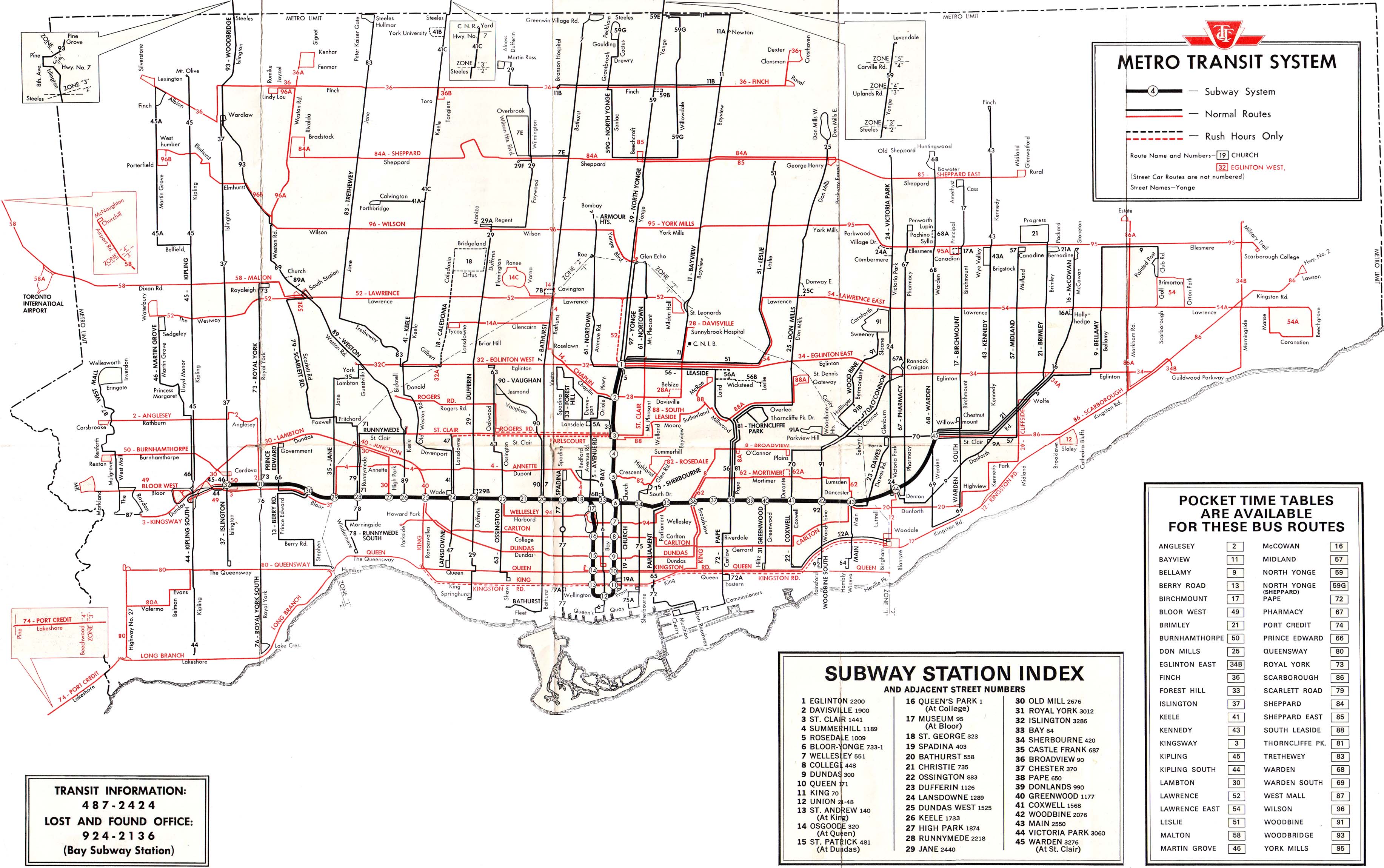
The 501 Queen is an east-west streetcar route in Toronto, Ontario, Canada, operated by the Toronto Transit Commission (TTC).[3] At 24.8 kilometres (15.4 mi), it is the longest surface route operated by the TTC, the longest streetcar route operating in North America and one of the longest streetcar routes operating in the world.[4] It stretches from Long Branch Loop (just west of Browns Line, adjacent to Long Branch GO Station) in the west to Neville Park Loop (just west of Victoria Park Avenue) in the east, running on Lake Shore Boulevard, in a reserved right-of-way at the median of The Queensway, and on Queen Street. The route was instituted in the mid-to-late-19th century by private operators as a horse-drawn line, was later electrified, and was assumed by the TTC upon its creation in 1921. Service is provided 24 hours a day, though the route number changes to 301 Queen late at night.
The 501 Queen is regularly operated with the TTC's double-length ALRVs between Neville Park and Humber and CLRVs from Neville Park to Long Branch. It runs every five to nine minutes between Neville Park and Humber, ten minutes from Humber to Long Branch, and 10 to 30 overnight from approximately 1:00 a.m. until 5:00 a.m. The route intersects with two stations on Line 1 Yonge–University of the Toronto Subway, specifically at Queen and Osgoode stations.
Former Route 507
Route 501 used to run only as far west as Humber Loop, which until 1973 was a fare zone boundary point.[5] Another route, 507 Long Branch, ran from Humber to Long Branch. The TTC decided in 1995 to amalgamate the two routes into one continuous route. However a similar arrangement was reinstated in January 2016 when the route was temporarily split in two stages with the 501 Queen streetcar now operating between Neville Park - Humber Loop and Humber Loop - Long Branch.[6]
Current route
- 501 Neville Park/501 Long Branch: Neville Park Loop to Long Branch Loop
- 501 Humber: Westbound from Neville Park Loop to Humber Loop
- 501 Roncesvalles: Westbound from Neville Park Loop to Queen and Roncesvalles Avenue
- 501 to Kingston Road: Eastbound from Long Branch, Humber Loop or Roncesvalles Avenue to Kingston Road.
Criticism
Critics of the TTC's management of this line argue that small delays at one end ripple into 30-40 minute waits at the other. Like route 504, there is much demand at either end of the route, and along the downtown middle stretch. Transit proponents such as Steve Munro have long claimed that Route 501 would be better off if it were split into two or three overlapping segments.[7]
2009 trial route splitting
The TTC conducted an experiment of splitting the 501 streetcar route into two overlapping segments, as recommended by the critics to alleviate bunching, gaps and short turns when delays occurred.[8][9]
During the experiment streetcars from the Neville Park Loop ran west on Queen as far as Shaw Street, and from Long Branch Loop or Humber Loop east as far as Parliament Street.[10]
In January 2010 the commission received a report analyzing several of the experiments done in 2009 to increase service reliability. It was determined that splitting the route increased short turns, required more streetcars and resulted in poorer service.[11][12]
2016 route splitting
On January 3, 2016, 501 Queen was split again, this time with one branch from Long Branch Loop to Humber Loop and the other from Humber Loop to Neville Park Loop. With this change, service on this whole route operates at intervals of ten minutes or better all day, every day. This change is temporary to concentrate the larger ALRV streetcars on the main part of the route east of Humber, while CLRV streetcars provide service from Neville Park to Long Branch on a more frequent service than before.[13][14]
Sites along the line (from east to west)
- Neville Park Loop
- The Beaches
- Broadview Avenue
- Moss Park
- Moss Park Armoury
- Queen station
- Yonge Street
- Eaton Centre
- Old City Hall courts
- Toronto City Hall, Nathan Phillips Square
- Osgoode Hall
- Osgoode station
- University Avenue
- Four Seasons Centre
- 299 Queen Street West (Home to MuchMusic, CP24, Bell Media)
- Spadina Avenue
- Trinity Bellwoods Park
- Ossington Avenue
- Centre for Addiction and Mental Health
- Drake Hotel
- Gladstone Hotel
- Parkdale
- High Park
- Humber Loop
- Long Branch Loop
Short turn locations
Every second car heading west is short turned at Humber Loop at the mouth of the Humber River. The most common locations for short turns outside of the schedule are Sunnyside loop just west of Roncesvalles Avenue beside the Roncesvalles Carhouse, and in the east, Woodbine Loop, just east of the junction of Queen Street East, Eastern Avenue, and Kingston Road.
501 streetcars are less commonly short turned at, ordered from east to west:
- Russell Carhouse – exclusively for streetcars that are going out of service. These cars are usually signed "501 Greenwood/Connaught"
- On street loop via Church Street, Richmond Street East, and Victoria Street – 501 Church
- McCaul Loop – 501 McCaul
- Spadina Avenue and King Street (Charlotte loop) – 501 Spadina
- Bathurst Street (Wolseley Loop) – 501 Bathurst
- Shaw Street turning onto King Street and Dufferin Street – 501 Shaw
- Dufferin Street and Springhurst Avenue (Exhibition West loop) – 501 Dufferin
- Kipling Avenue – 501 Kipling
Former subway plans
The TTC's subway plans in the 1940s and 1950s called for the north-south rapid transit line built under Yonge Street (the first section of today's Yonge-University line) to be complemented by an east-west streetcar subway under Queen Street, allowing streetcars to avoid city-centre traffic, but come above ground and run on city streets in outlying areas. When the Government of Canada refused to help fund the project, the Queen line was dropped to save money, but a set of streetcar platforms were built under Queen station to allow for further expansion. By the time the TTC returned to the idea of an east-west line, however, traffic had moved north to Bloor Street, and the Bloor-Danforth line was built there as a dedicated rapid-transit line like that under Yonge.
Proposed right-of-way
On April 2, 2007, the TTC proposed that the 501 Queen streetcar route operate in a transit-only right-of-way similar to the proposal for the 504 King streetcar route announced on March 22, 2007. These plans have been all but shelved; the TTC is now focusing on King street for a transit mall because of objections from merchants on Queen St. who claim their businesses are more car-based than that of King.
References
- ↑ "Ridership and cost statistics for bus and streetcar routes, 2011" (PDF). Toronto Transit Commission. April 2011. Retrieved 2 January 2012.
- 1 2 Toronto Transit Commission (September 18, 2009). "TTC Service Summary" (PDF).
- ↑ Vanessa Farquharson (2012-03-24). "Riding the 501: The longest streetcar route in North America". National Post. Archived from the original on 2013-02-24.
With nearly 25 kilometres of track, the 501 Queen is the longest streetcar route operating in North America.
- ↑ Christopher Hume (2007-12-29). "It's not too good if you're in a hurry, but the 501 does give a wonderful look at city's many faces". Toronto Star. p. A.3. Retrieved 2013-02-24.
Torontonians who ride it daily might not be impressed, butNational Geographic has named the Queen streetcar, the 501, one of the top 10 trolley routes in the world. The honour is included in a new book, Journeys of a Lifetime 500 of the World's Greatest Trips.
- ↑ As seen on this 1968 map.
- ↑ "501 Queen - Service increase". Toronto Transit Commission. 3 January 2016. Retrieved 19 January 2016.
The route will be temporarily split into two separate sections, operating between Long Branch Loop and Humber Loop, and between Neville Park Loop and Humber Loop.
- ↑ Kuitenbrouwer, Peter (2007-11-24). "Crown jewel badly tarnished". National Post. Toronto. Retrieved 2008-01-21.
- ↑ "TTC temporarily splits 501 streetcar route". CBC News. 2009-10-19. Archived from the original on 2013-02-24.
Toronto transit advocate Steve Munro said that people who are travelling downtown from the outer ends of the city will still be able to make the trip in one ride.
- ↑ Thandiwe Vela (2009-10-15). "TTC to split Queen streetcar route". Toronto Star. Archived from the original on 2013-02-24.
On weekdays between Oct. 19 and Nov. 20, the west portion of the route will run from Long Branch to Parliament St. while the east portion will run from Neville Park to Shaw St., the TTC announced in a statement. Saturday, Sunday and holiday service will not be changed.
- ↑ "October 2009 - Service changes effective October 18, 2009". TTC. October 2009. Archived from the original on 2009-10-19. Retrieved 2009-09-22.
- ↑ "501 Queen Streetcar Route: Final Recommendations" (PDF). TTC. 2010-01-20. Retrieved 2012-07-29.
- ↑ Tess Kalinowski (2010-01-19). "TTC gives up attempt to divide Queen route". Toronto Star. Archived from the original on 2013-02-24.
A report before the city councillors on the Toronto Transit Commission on Wednesday shows that splitting the route in half actually increased the number of short turns by 90 per cent overall during a five-week experiment last October and November.
- ↑ Verity Stevenson (3 January 2016). "Queen streetcar riders get what they've waited for: more service". Toronto Star. Retrieved 2016-01-03.
- ↑ Steve Munro (3 January 2016). "501 Queen Service Design Effective January 3, 2016". Retrieved 2016-01-03.
External links
| Wikimedia Commons has media related to 501 Queen. |
- TTC Official Site
- Route 501 - The Queen Streetcar (Transit Toronto)
- 501 Queen map
- Photo tour of 501 Queen (Transit Toronto)
| Bus |  _(14918534190).jpg) | |
|---|---|---|
| Subway | ||
| Streetcars | ||
| History | ||
| Predecessors |
| |
| Facilities | ||
| Proposed | ||
| Miscellaneous | ||
Italics indicate a project under construction | ||