A4 road (Latvia)
| ||||
|---|---|---|---|---|
| Rīgas apvedceļš | ||||
 | ||||
| Route information | ||||
|
Part of | ||||
| Length: | 20.5 km (12.7 mi) | |||
| Major junctions | ||||
| From: | Baltezers | |||
| To: | Saulkalne | |||
| Highway system | ||||
| ||||
The A4 is a national road in Latvia which is part of the ring road around Riga, connecting Baltezers to Saulkalne.[1] The road is also known as the Riga bypass. The road is part of European route E67, European route E77 and Latvian TEN-T road network. The length of the A4 is 21 kilometers. Construction on A4 was started in 1964 and finished in 1980. Currently the A4 has 1+1 lanes in all its length. In 2011/2012 part of the A4 was reconstructed,[2] and its planned that around year 2020 widening of the road to 2x2 lanes will start. Because of this, it would receive an expressway or motorway status, and the current 90 km/h speed limit would be raised.[3] The average AADT of A4 in 2015 was 10 318 cars per day.
Crossings
| # | Road name | Location |
|---|---|---|
| 1 | P1 | Upesciems |
| 2 | P4 | Ūlupji |
| 3 | P11 | Saurieši |
| 4 | A6 | Saulkalne |
Major cities crossed
Gallery
-
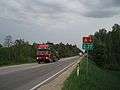
A4 in 2007.
References
![http://www.lvceli.lv/LV/PC/PageImages/Original/1473.jpg[]](http://www.lvceli.lv/LV/PC/PageImages/Original/1473.jpg[])
External links
Coordinates: 56°55′53″N 24°23′17″E / 56.931516°N 24.388142°E