A77 autoroute
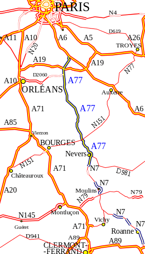
The A77 autoroute is a motorway in central France. The road starts at the hamlet of Rosiers in Seine-et-Marne and finishes to the south of Nevers in Nièvre. It is also known as the l'Arbre - the motorway of the Tree.
It has been designed to minimise its effect on the environment. Each of the rest areas bears the name of a species. The road has been integrated into the landscape helped by zoologists to allow the passage of the animals (wild or cattle) from one side of the road to the other, as in the forest of Montargis. This added to the cost of construction.
Rosiers to Cosne-Cours-sur-Loire
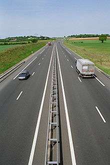
The motorway is managed by the company the Paris-Rhine-Rhone (SAPRR). It is a toll road with 2x2 lanes and totals 96 km.
- Before 1999: The A77 was formed by re-numbering an old motorway connection to the A6 autoroute. The road was the upgraded N7 to Dordives. The toll road follows the valley of the Loing.
- 1999: Opening of the Dordives - Briare section of 68 km
- 2000: Opening of the Briare - Cosne-Cours-sur-Loire section of 33 km
- 2009: Opening of the junction with the A19 autoroute.
Junctions
-
 Exchange A6-A77 Exchanging half between A6 and A77
 -
 17 (Dordives) 5 km: Towns served: Dordives, Souppes-sur-Loing, Château-Landon, Ferrières-en-Gâtinais
 - Exchange A19-A77 Junction with the A19 autoroute
-
 Rest areas: L'Hêtre Poupre/Le Sophora
-
- 18 (Montargis) 28 km: Towns served city Montargis
- Rest areas: Le Cèdre/Le Liquidambar
-
- 18.1 (Varennes-Changy): Towns served: Varennes-Changy
-
 Service Area: Jardin des Arbres
-
- 19 (Nogent-sur-Vernisson Gien) to 54 km: Served cities Gien and Nogent-sur-Vernisson
- Rest areas: Gingko feel Paris-Province, Tulipier feel Province-Paris
-
- 20 (Briare) to 67 km: served city Briare
- 21 (Auxerre/Saint-Fargeau) to 80 km: Towns served: Bonny-sur-Loire, Saint-Fargeau 62 km Auxerre
- Rest areas: Caule/Séquoïa
-
- 22 (Cosne-sur-Loire/Saint-Amand-en-Puisaye) 97 km: Towns served: Cosne-sur-Loire Saint-Amand-en-Puisaye
Cosne-sur-Loire to Nevers-South
The motorway is managed by the département of Nièvre. It is a free motorway with 2x2 lanes.
- From 1992 to 2004: Phased opening of the section Cosne to Nevers-South
Junctions
- 22.1 (Cosne-sur-Loire-centre) 99 km: Towns served: Cosne-sur-Loire
- 23 (Cosne-sur-Loire-Sud) 103 km: Towns served: Cosne-sur-Loire
- 24 (Malataverne) 108 km: Towns Served: Sancerre and Saint-Laurent-l'Abbaye
- Service Area:
-
- 25 (Pouilly-sur-Loire-nord) 108 km: Towns served: Pouilly-sur-Loire which is located pile at the medium between the source and the mouth of the Loire Rest area of Pouilly feel Paris-Province
- 26 (Pouilly-sur-Loire-sud) 112 km: Towns served: Pouilly-sur-Loire
- Rest area: Pouilly
-
- 27 (Mesves-sur-Loire) 117 km: Towns served: Mesves-sur-Loire
- 28 (Charité-sur-Loire-nord) 119 km: Towns served: La Charité-sur-Loire
- 29 (Charité-sur-Loire-Center) 122 km: Towns served: La Charité-sur-Loire
- 30 (La Marche) 129 km: Towns served: La Marche
- 31 (Pougues-les-Eaux Nord) 136 km: Towns served: Pougues-les-Eaux
- Rest Area: Pougues-les-Eaux
-
- 32 (Varennes-Pougues-les-Eaux) 143 km: Towns served: Pougues-les-Eaux and Varennes-Vauzelles Z.I.
- 33 (Nevers-center) 145 km: Towns served: Nevers Center, Varennes-Vauzelles, Château de la Rocherie
- 34 (Nevers-sud St-Éloi) 150 km: Towns served: Nevers
- 36 (Saint-Éloi) 154 km: Towns served: Saint-Éloi, Decize
- 37 (Nevers-sud)) 158 km: Towns served: Nevers
- Rest area: Faience Manufacturers
-
Nevers to Moulins
Plans are to extend the motorway to Moulins, with sections already under construction on the existing RN7. The by-pass of Moulins and Villeneuve-sur-Allier has already been completed to autoroute standard. The remaining upgrade is expected to be completed in 2009.
External links
| Wikimedia Commons has media related to A77 autoroute. |
 |
| | |