Abbey of Kells
| Mainistir Cheanannais | |
|
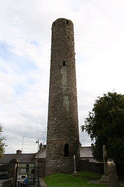
Round tower at Kells | |
 Location within Ireland | |
| Monastery information | |
|---|---|
| Established | 6th century/early 9th century |
| Disestablished | 12th century |
| People | |
| Founder(s) | Columba/Cellach of Iona |
| Site | |
| Location | Kells, County Meath, Ireland |
| Designations | |
|---|---|
| Official name | Kells (round tower & High Crosses) |
| Reference no. | 158 |
The Abbey of Kells (Mainistir Cheanannais in Irish) is a former monastery in Kells, County Meath, Ireland, 40 miles (64 km) north of Dublin. It was founded in the early 9th century, and the Book of Kells was kept there during the later medieval and early modern periods before finally leaving the abbey in the 1650s. Much of the Book of Kells may have been created there, but historians cannot be certain of the exact date and circumstances of its creation.
History
The Abbey of Kells was reportedly founded by St. Columba ca. 554, after High King Diarmuid Mac Caroll of Tara granted the land.[1][2]:4
A refounding may have happened in the early 9th century by Columban monks fleeing from Iona which was repeatedly raided by the Vikings. The site was a former Irish hill fort. In 814, Cellach, Abbot of Iona, retired to Kells. After further Viking raids, goods and relics from the abbey were transferred to other Columban houses inland, including Raphoe, Dunkeld and the Abbey of Kells.
Book of Kells
It is believed that the Book of Kells may have been either started in Iona and finished in Kells or written entirely in Kells by successive generation of monks.
The Vikings continually raided the abbey during the 10th century and it was repeatedly sacked and pillaged. Despite the constant raids, the monks managed to keep the Book of Kells intact until 1006 when it was stolen from the shrine. A reference in the Annals of Ulster is generally believed to refer the theft of the Book of Kells and it relates that the manuscript was returned after two months without its cover. The force of the removal of the cover probably explains the missing illustrations at the beginning and end of the book.
The book was stored in the abbey for the remainder of the Middle Ages. In the 12th century, details of land charters for the abbey were copied onto blank pages of the Book of Kells as was common practice for the period. This is the earliest confirmed reference to its presence at the abbey. Later in the same century, the monastery was dissolved with the abbey becoming a parish church and the Book of Kells continued to be kept there. Catholic landowners acquired the land.
The Book of Kells remained at Kells until the 1650s when Cromwell's troops were stationed in the town. At that point it was sent to Dublin for safekeeping. In 1661, the Book of Kells ended up in Trinity College, Dublin where it has stayed ever since.
Description
Today, the monastic site includes a 10th-century round tower that rises around 90 feet from the original street level. It has five windows on the top floor rather than the usual four, overlooking the five roads leading into Kells.[2]:4
The current church building (Church of Ireland) dates to 1778 and was renovated in 1965.[3][2]:4
Nearby is St. Columb's House, a 10th-century oratory. There are also a number of 9th- to 10th-century High Crosses. Three crosses and a cross base are located on the site itself, whilst the 9th-century "Market Cross" (originally at the abbey's eastern gate) is now located in front of the old courthouse. Legend has it that it was damaged by Cromwellian soldiers and that it was used to hang participants of the 1798 rebellion.[2]:4-5
The round tower and high crosses are a National Monument of Ireland.[4]
The monastic site is open to the public.
See also
- The Secret of Kells, a 2009 animated film set in the abbey
References
- ↑ Sidwell, Keith (1995), Reading Medieval Latin, Cambridge University Press, p. 70, ISBN 0-521-44747-X
- 1 2 3 4 Kells & District (PDF). Kells & District Tourism Forum.
- ↑ "National Inventory of Architectural Heritage - Saint Columcille's Church of Ireland Church, Kells, County Meath". Department of Arts, Heritage & the Gaeltacht. Retrieved 11 October 2016.
- ↑ https://www.archaeology.ie/sites/default/files/media/pdf/monuments-in-state-care-meath.pdf
- Sir Edward Sullivan, The Book of Kells Bracken 1988 (reprint of 1920 edition) ISBN 1-85170-196-6
- Carol Farr, The Book of Kells: Its Function and Audience, British Library 1997 ISBN 0-7123-0499-1
- Forbes, Andrew ; Henley, David (2012). Pages from the Book of Kells. Chiang Mai: Cognoscenti Books. ASIN: B00AN4JVI0
- George Henderson, From Durham to Kells: The Insular Gospel Books 650-800 Thames and Hudson 1987 ISBN 0-500-23474-4
External links
- Long Island University site on the Book of Kells
- History, Construction and Knotwork of the Book of Kells
- School of Kells - Article from the Catholic Encyclopedia
Coordinates: 53°43′38″N 6°52′48″W / 53.72729°N 6.88007°W