Abe River
| Abe River | |
|---|---|
|
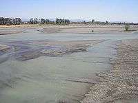
Abe River at Shizuoka | |
| Native name | 安倍川 |
| Country | Japan |
| Basin | |
| Main source |
Akaishi Mountains 2,000 m (6,600 ft) |
| River mouth |
Suruga Bay 0 m (0 ft) |
| Basin size | 567 km2 (219 sq mi) |
| Physical characteristics | |
| Length | 53.3 km (33.1 mi) |
The Abe River (安倍川 Abe-kawa) is a river in Shizuoka Prefecture of central Japan. It is 53.3 kilometres (33.1 mi) long and has a watershed of 567 square kilometres (219 sq mi).[1]
The river rises from Akaishi Mountains which stretch over the border between Yamanashi and Shizuoka Prefectures, and flows into Suruga Bay in the Pacific Ocean). It is known for its clear stream and forms part of the main water supply for Shizuoka city.
There are many hot springs at the river head, which is also known for its numerous landslides and for the Abe Great Falls, one of Japan's Top 100 Waterfalls. Unlike the nearby Tenryū River and Ōi River are no dams on the Abe River.
Shogun Tokugawa Ieyasu carried out extensive construction and formed the present route of the lower course of the river. Abekawamochi (安倍川餅), a mochi rice cake dusted with kinako (soybean flour) has been a local speciality of this area since at least the Edo period.[2]
References
34°55′47″N 138°23′38″E / 34.929749°N 138.393806°ECoordinates: 34°55′47″N 138°23′38″E / 34.929749°N 138.393806°E (mouth)