Aber-arad
| Aber-arad | |
 Aber-arad |
|
| Community | Newcastle Emlyn |
|---|---|
| Principal area | Carmarthenshire |
| Ceremonial county | Dyfed |
| Country | Wales |
| Sovereign state | United Kingdom |
| Post town | NEWCASTLE EMLYN |
| Postcode district | SA38 |
| Dialling code | 01239 |
| EU Parliament | Wales |
| UK Parliament | Carmarthen East and Dinefwr |
| Welsh Assembly | Carmarthen East and Dinefwr |
|
|
Coordinates: 52°02′02″N 4°27′32″W / 52.034°N 4.459°W
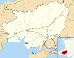
Aber-arad is a village in the Welsh principal area of Carmarthenshire.[1] Aber-Arad lies less than one mile to the east of Newcastle Emlyn.
In 1870-72, John Marius Wilson in the Imperial Gazetteer of England and Wales described Aber Arad as:
ABERARAD, a village in the parish of Kenarth, Carmarthen; a mile east of Newcastle-Emlyn.[2]
References
- ↑ Ordnance Survey: Landranger map sheet 145 Cardigan & Mynydd Preseli (Map). Ordnance Survey. 2010. ISBN 9780319231005.
- ↑ "A Vision of Britain Through Time: Aber-arad". GB Historical GIS/University of Portsmouth. Retrieved 27 January 2016.
This article is issued from Wikipedia - version of the 1/27/2016. The text is available under the Creative Commons Attribution/Share Alike but additional terms may apply for the media files.