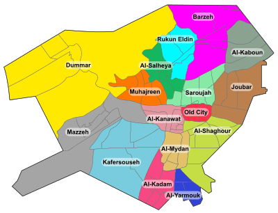
Abu Jarash
Abu Jarash (Arabic: أبو جرش) is a neighborhood and district of the al-Salihiyah municipality of Damascus, Syria. It had a population of 12,798 in the 2004 census.[1] In the 1936 French Mandate census, ABu Jarash had a population of 9,600, all Muslims.[2] The neighborhood was built around the domed mausoleum of Abu Jarash,[3] also known as Abdallah ibn Sala al-Raqqi, a high-ranking Ayyubid royal court official.[4]
References
|
|---|
|
| |
|
| |
|---|
| | Districts: |
- Al-Abbas
- Barza al-Balad
- Ish al-Warwar
- Al-Manara
- Masakin Barzeh
- An-Nuzha
|
|---|
|
|
|
| |
|---|
| | Districts: |
- Al-Arin
- Dahiyet Dummar
- Dummar al-Gharbiyah
- Dummar al-Sharqiyah
- Al-Wuroud
|
|---|
|
|
|
| |
|---|
| | Districts: |
- Jobar Gharbi
- Jobar Sharqi
- Al-Istiqlal
- Al-Ma'muniyah
|
|---|
|
|
|
| |
|---|
| | Districts: |
- Fardos
- Al-Ikhlas
- Kafr Souseh al-Balad
- Al-Liwan
- Mezzeh al-Basatin
- Al-Waha
|
|---|
|
|
|
| |
|---|
| | Districts: |
- Al-Jalaa
- Fe'alat al-Gharbiyah
- Fe'alat al-Sharqiyah
- Mezzeh 86
- Mezzeh al-Qadimeh
- Mezzeh Jabal
- Al-Rabwa
- Al-Sumariyah
|
|---|
|
|
|
|
|
| Muhajirin |
|---|
| | Districts: |
- Abu Rummaneh
- A-Haboubi
- Al-Maliki
- Al-Marabit
- Al-Mastaba
- Al-Rawda
- Shura
|
|---|
|
|
|
| |
|---|
| | Districts: |
- Al-Masaneh'
- Qabun
- Tishrin
|
|---|
|
|
|
| |
|---|
| | Districts: |
- Al-Asali
- Dahadil
- Jouret al-Shreibati
- Al-Mustafa
- Al-Qadam
- Qadam Sharqi
- Al-Sayyidah Aisha
|
|---|
|
|
|
|
|
| |
|---|
| | Districts: |
- Asad ad-Din
- Ayyubiyah
- Al-Fayhaa
- Al-Naqshabandi
|
|---|
|
|
|
| |
|---|
| | Districts: |
- Abu Jarash
- Al-Madaris
- Al-Mazra'a
- Qasyoun
- Shaykh Muhyi ad-Din
- Ash-Shuhada
|
|---|
|
|
|
|
|
|
|
| |
|---|
| | Districts: |
- Al-Faluja
- Hittin
- Al-Karmil
- An-Naseriyah
- March 8th
- Al-Taqqadum
|
|---|
|
|