Ackerstraße
 | |
|---|---|
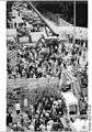
 Pappelplatz, the square at the bend in the Ackerstraße | |
| Length | 1,500 m (4,900 ft) |
| Addresses | Berlin-Mitte, Berlin-Gesundbrunnen |
| Construction | |
| Construction start | mid-18th century |
| Completion | 1877 |
The Ackerstraße is a street in Berlin which runs northwest from near the Liesenstraße – Scheringstraße traffic circle in Gesundbrunnen to Invalidenstraße, where it turns south, terminating at the Linienstraße in Mitte.
History
On 22 September 1751, Lieutenant General Hans Christoph Friedrich Graf von Hacke, commandant of the city of Berlin, received orders from King Frederick II of Prussia to build houses outside the city Customs Wall between the Hamburg Gate and the Rosenthal Gate.[1] Initially 30 houses were to be built, to house 60 families selected from applicants. The objective was to have the craftsmen stay year-round in Berlin rather than leaving each winter. The new residents were mostly from Vogtland; as a result the new area of settlement came to be called Neuvoigtland (New Vogtland).[1] The streets were laid out in parallel straight lines and were designated numerically; what is now the Ackerstraße was the middle street and was originally called the Zweite Reihe (second row), and became the Dritte Reihe (third row) when the local population increased in the 19th century and new streets were added.[1] The district was divided into identical land parcels with approximately 10.5 metres (34 ft) frontages[2] and to save money and time, the original houses were standardised; this set a new trend. Gardens were laid out between them, but the population increase led to extension of the buildings as the area became more urban.
The area changed name to Rosenthaler Vorstadt, and the local residents petitioned the police for street names to be assigned. On 18 February 1801 the "third row" was renamed Ackerstraße (Field Street), probably because the development was in the farming area outside the city, the Feldmark.[1] On 6 April 1833, the continuation of the same street, from Invalidenstraße to Liesenstraße, was named Neue Ackerstraße (New Ackerstraße). The southern extension to Koppenplatz was added in 1877. The residents there preferred the name Virchowstraße, but their request was denied.[1]
The St. Elisabeth Cemetery near the midpoint of the street was dedicated in 1844 and is still in operation.[3]
In the 1870s and 1880s, the character of the street was greatly changed with the building of tenements. The Ackerhöfe at numbers 14–15, unusual in occupying two of the original land parcels, are a restored complex of tenements built in four phases between 1867 and 1911, the last phase representing an attempt at housing reform.[2] The most notorious tenement in Berlin, Meyers Hof, was at number 132.[4][5] One of the original covered markets of Berlin, now known as the Ackerhalle, was built on the corner with Invalidenstraße in 1886–88 and is still in use; it is the only one that retains its original façade.[6]
19 historic buildings on the street are protected historic monuments of the city of Berlin: 1–5, 10–13, 16/17, 19–22, 144–147, 154/155, 165, and 171.[7]
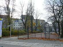
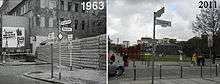
From 1961 to 1989, the Berlin Wall divided the city. It ran along Bernauer Straße, and required closing a section of Ackerstraße at the corner with that street, which fell within the "death strip"; a church in this part of Ackerstraße, the Versöhnungskirche (Church of Reconciliation), was dynamited by the East German authorities in 1985.[6][8] In commemoration of the Wall and those who died attempting to cross it, a portion of the main and inner walls and the "death strip" are preserved on Bernauer Straße at the corner of Ackerstraße as part of the Gedenkstätte Berliner Mauer (Berlin Wall Memorial);[9] 212 metres (696 ft) of the border strip along Bernauer Straße between Ackerstraße and Bergstraße were made a protected landmark on 2 October 1990[10] and this is now the last genuine remnant of the Wall.[4][11]
In literature
- The novel Das Mädchen aus der Ackerstraße (the girl from the Ackerstraße) is set in the area in the 19th century, when it was an impoverished neighbourhood.[12] It was filmed in 1919–20 in three parts directed by Reinhold Schünzel and Werner Funck with cinematography by Kurt Kurant (Curt Courant).[13][14]
- The protagonists of Klaus Kordon's Trilogie der Wendepunkte, a trilogy of novels for teenagers in which a family lives through the end of both World Wars, Die roten Matrosen, Mit dem Rücken zur Wand, and Der erste Frühling, live in the Ackerstraße.[15]
-
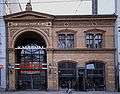
Ackerhalle, late 19th-century market hall at Ackerstraße and Invalidenstraße
-
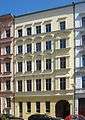
Former tenement at number 13, one of the protected historic landmarks in Ackerstraße
-
Demolition of the Berlin Wall at the corner of Bernauer Straße and Ackerstraße in 1990
-
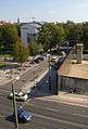
Section of the street as part of the Gedenkstätte Berliner Mauer, photographed in 2011
References
- 1 2 3 4 5 Geschichte von Ackerstraße, Straßennamenlexikon des Luisenstädtischen Bildungsvereins, at Kauperts Straßenführer durch Berlin, online ed. (German), retrieved 23 July 2012.
- 1 2 Ackerhöfe, Ackerstraße 14–15, Stadterneuerung - Mitte - Rundgang Rosenthaler Vorstadt, Senatsverwaltung für Stadtentwicklung und Umwelt, Berlin (German), retrieved 23 July 2012
- ↑ Friedhof der Elisabeth-Gemeinde, Denkmale in Berlin, Senatsverwaltung für Stadtentwicklung und Umwelt, Berlin (German), retrieved 23 July 2012.
- 1 2 Ingrid Nowel, Berlin: Die neue Hauptstadt: Architektur und Kunst, Geschichte und Literatur, Dumont Kunstreiseführer, Cologne: DuMont, 2001, ISBN 9783770155774, p. 324 (German)
- ↑ Sabine Hake, Topographies of Class: Modern Architecture and Mass Society in Weimar Berlin, Social history, popular culture, and politics in Germany, Ann Arbor: University of Michigan, 2008, ISBN 9780472070381, p. 281.
- 1 2 Petra Dubilski, Berlin, Dumont Reise-Taschenbücher, Cologne: DuMont, 2001, ISBN 9783770155965, p. 217 (German)
- ↑ Ensemble ehem. Voigtland, Denkmale in Berlin, Senatsverwaltung für Stadtentwicklung und Umwelt, Berlin (German), retrieved 23 July 2012.
- ↑ Michael Magercord, Meine Mauer: Fotografien eines Westberliners 1986 bis 1993, Erfurt: Sutton, 2011, ISBN 9783866807860, pp. 72–73 (German)
- ↑ Damien Simonis, Berlin, National Geographic traveler, Washington, DC: National Geographic Society, 2006, ISBN 9780792262121, p. 114.
- ↑ Alexandra Tacke, "Die Mauer im Kopfe: Mauerbau & -fall im kollektiven Gedächtnis", in NachBilder der Wende, ed. Inge Stephan and Alexandra Tacke, Literatur, Kultur, Geschlecht, Kleine Reihe 25, Cologne: Böhlau, 2008, ISBN 9783412200831, pp. 301–18, note 41, p. 317 (German)
- ↑ "Dokumentationszentrum Berliner Mauer", in Orte des Erinnerns: Gedenkzeichen, Gedenkstätten und Museen zur Diktatur in SBZ und DDR, ed. Annette Kaminsky with Ruth Gleinig and Oliver Igel, Forschungen zur DDR-Gesellschaft, 2nd ed., Berlin: Links, 2007, ISBN 9783861534433, pp. 77–79 (German)
- ↑ Hermann Fleischack writing as Ernst Friedrich, Das Mädchen aus der Ackerstraße: ein Sittenbild aus Groß-Berlin, Leipzig: Vogel & Vogel, [1919], OCLC 43396048, German National Library (German)
- ↑ Das Mädchen aus der Ackerstrasse - 1. Teil; Das Mädchen aus der Ackerstrasse - 2. Teil; Das Mädchen aus der Ackerstrasse - 3. Teil at Filmzeit.de (German)
- ↑ Hans-Michael Bock and Tim Bergfelder, The Concise CineGraph: Encyclopaedia of German Cinema, Film Europa 1, New York: Berghahn, 2009, ISBN 9781571816559, p. 74.
- ↑ Katrin Müller-Walde, Warum Jungen nicht mehr lesen und wie wir das ändern können, Frankfurt: Campus, 2005, ISBN 9783593375823, p. 181 (German)
Further reading
- "Ackerstraße — dazumal in der Sahara". In: Laurenz Demps. Historisches Berlin-Lexikon: 75 Folgen aus der seit 1982 veröffentlichten Serie der "BZ am Abend". Berlin: Berliner Verlag, 1987. ISBN 9783860200063 (German)
- Harald Bodenschatz. Platz frei für das neue Berlin!: Geschichte der Stadterneuerung in der "grössten Mietskasernenstadt der Welt" seit 1871. Studien zur neueren Planungsgeschichte 1. Berlin: Transit, 1987. ISBN 978-3-88747-038-8 (German)
- Sybille Schulze. Erinnerungen an die Ackerstraße. Norderstedt: Books on Demand, 2011. ISBN 978-3-8448-0663-2 (German)
- Gerrit Wegener. Die Versöhnungskapelle in Berlin-Mitte. On demand. Munich: GRIN, 2007. ISBN 9783638845946 (German) (on the demolished church)
External links
| Wikimedia Commons has media related to Ackerstraße. |
- Sensing the Street, 2007–08 exhibition by the Berlin University of the Arts on Ackerstraße, Adalbertstraße and Karl-Marx-Straße
Coordinates: 52°32′07″N 13°23′25″E / 52.535401°N 13.390317°E