Ackling Dyke
Ackling Dyke is a section of Roman road in England which runs for 22 mi (35 km) southwest from Old Sarum (Sorviodunum) to the hill fort at Badbury Rings (Vindocladia). Part of the road on Oakley Down has been scheduled as an ancient monument.[1]
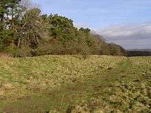
Much of the road exists as an exceptionally large embankment (agger), up to 50 ft (15 m) wide and 6 ft (1.8 m) high. This is much wider than most Roman roads.[2] This would have been visible from a great distance and must have been intended to impress the native population,[3] as it was unnecessary from an engineering viewpoint.[4] It provided a rapid transit route for soldiers across Cranborne Chase.[5]
In addition, in places the road cuts straight through prehistoric earthworks and barrows, showing the Roman attitude to the existing British social structure as well as proving to early antiquaries that barrows preceded the Roman period.[6][7] At Bokerley Junction it cuts through both Bokerley Dyke and Grim's Ditch before being overlaid by the A354 turnpike. 5 kilometres (3.1 mi) further west at Wyke Down it cuts through the Dorset Cursus. A series of watchtower sites have been identified along the route.[8]
After leaving the Salisbury suburbs, the route crosses open country throughout, and nowhere comes close to any settlement. Apart from a one-mile section of the main Salisbury - Blandford road which follows its course, the road can mostly be followed along minor lanes and tracks.
At Old Sarum the road connected with the Port Way to Silchester (Calleva Atrebatum) and London; and from Badbury Rings roads led to the harbour at Hamworthy (Moriconium) and to Dorchester (Durnovaria).[9]
Part of the road is on the Heritage at Risk Register because of the potential damage from arable ploughing.[10]
References
- ↑ "Part of the Ackling Dyke Roman road 900m east of Down Farm". National Heritage List for England. Historic England. Retrieved 3 September 2016.
- ↑ Otter, R. A. (1994). Civil Engineering Heritage. Institution of Civil Engineers by Thomas Telford. pp. 130–131. ISBN 978-0727719713.
- ↑ "Ackling Dyke, Dorset". Open University. Retrieved 3 September 2016.
- ↑ Margary, I D. Roman Roads in Britain: Volume I. Phoenix House Ltd., 1955
- ↑ Lane, Roger (2015). Cranborne Chase. Amberley. ISBN 9781445649856.
- ↑ Barrett, John; Bradley, Richard J.; Green, Martin T. (1991). Landscape, Monuments and Society: The Prehistory of Cranborne Chase. Cambridge University Press. p. 233. ISBN 9780521321280.
- ↑ Berry, Joanne; Laurence, Ray (2002). Cultural Identity in the Roman Empire. Routledge. p. 87. ISBN 9781134778515.
- ↑ Lauire, Peter. "A roman watch tower and surveyors' mark near Hardy's Monument" (PDF). Notes on Roman military roads and culverts in W Dorset. Peter Laurie. Retrieved 3 September 2016.
- ↑ Map of Roman Britain, Ordnance Survey
- ↑ "Part of Ackling Dyke (Roman road), including Roman road on Oakley Down, Gussage All Saints / Gussage St. Michael / Pentridge / Wimborne St. Giles - East Dorset". Heritage at Risk. Historic England. Retrieved 3 September 2016.
See also
External links
| Wikimedia Commons has media related to Ackling Dyke. |
Coordinates: 50°56′20″N 1°59′04″W / 50.9388°N 1.9844°W