Actual Ground Position Line
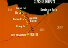
The Actual Ground Position Line (AGPL) is the line that divides current positions of Indian and Pakistani troops in the Siachen Glacier region.[1][2] The line extends from the northernmost point of the LOC (Line of Control) to Indira Col. The AGPL is approximately 110 kilometres (68 mi) long.[3][4]
History
The Siachen Glacier and the bordering Saltoro Ridge first saw military action in 1984 when the Indian Army controlled the glacier and the Saltoro range to pre-empt a Pakistani action to do the same. This operation was codenamed Operation Meghdoot (Divine Messenger of the clouds). There have been several minor changes to the held positions, however the Indian Armed forces have held onto the heights of the Saltoro Range.
Geographical location

This line runs across the edge of the Saltoro Ridge, which is a mountainous plateau with peaks which have heights in excess of 7,000 meters. The Indian soldiers hold on to the heights on the plateau, preventing the Pakistani soldiers from climbing up the Saltoro Range. The current position of the AGPL follows the general line:
Indira Col - Sia La pass - Saltoro Kangri 1 - Bilafond La pass - K12 - Gyong La pass - NJ9842[5]
See also
References
- ↑ The fight for Siachen
- ↑ "Archived copy". Archived from the original on 2015-04-12. Retrieved 2015-04-07.
- ↑ They shall not pass
- ↑ Bullish on siachen
- ↑ "Manning the Siachen Glacier". Bharat Rakshak Monitor. 2003. Retrieved 2011-01-27.