Adie Inlet
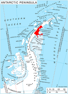
Location of Oscar II Coast on Antarctic Peninsula.
Adie Inlet (66°25′S 62°20′W / 66.417°S 62.333°WCoordinates: 66°25′S 62°20′W / 66.417°S 62.333°W) is an ice-filled inlet, 25 miles (40 km) long in a northwest–southeast direction, lying east of Churchill Peninsula along the east coast of Graham Land. Charted by the Falkland Islands Dependencies Survey (FIDS) and photographed from the air by the Ronne Antarctic Research Expedition (RARE) during 1947. Named by the FIDS for R.J. Adie, South African geologist with FIDS, 1947–49.
![]() This article incorporates public domain material from the United States Geological Survey document "Adie Inlet" (content from the Geographic Names Information System).
This article incorporates public domain material from the United States Geological Survey document "Adie Inlet" (content from the Geographic Names Information System).
This article is issued from Wikipedia - version of the 11/21/2015. The text is available under the Creative Commons Attribution/Share Alike but additional terms may apply for the media files.