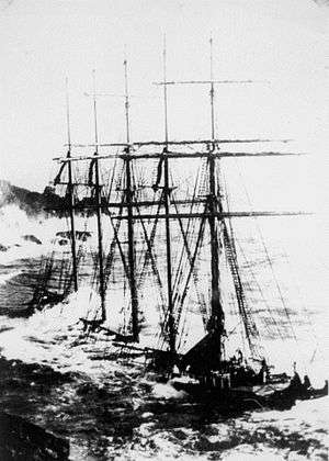
Adolf Vinnen (barquentine)
 Adolf Vinnen at Bass Point | |
| History | |
|---|---|
| Germany | |
| Name: | Adolf Vinnen |
| Owner: | F A Vinnen & Co |
| Port of registry: |
|
| Builder: | Friedrich Krupp Germaniawerft |
| Yard number: | 420 |
| Launched: | December 1922 |
| In service: | February 1923 |
| Out of service: | 9 February 1923 |
| Fate: | Wrecked |
| General characteristics | |
| Tonnage: | 1,840 GRT |
| Length: | 79.90 m (262 ft 2 in) |
| Beam: | 10.40 m (34 ft 1 in) |
| Depth: | 5.80 m (19 ft 0 in) |
| Propulsion: | Sails, two diesel engines. |
| Sail plan: | Barquentine |
| Complement: | Up to 45 |
Adolf Vinnen was a five-masted barquentine that was built by Friedrich Krupp Germaniawerft, Kiel, Germany. She was wrecked on her maiden voyage in 1923.
Description
Adolf Vinnen was a 1,849 GRT five-masted barquentine. She was 79.90 metres (262 ft 2 in) long, with a beam of 10.40 metres (34 ft 1 in) and a depth of 5.80 metres (19 ft 0 in). She was propelled by sails and two 350 horsepower (260 kW) 4-cylinder diesel engines. She was designed for a crew of 45.[1]
History
Adolf Vinnen was built in 1922 by Friedrich Krupp Germaniawerft, Kiel.[1] Launched in December 1922,[2] she was yard number 420.[3] She was built for F A Vinnen & Co, Bremen.[1]
On 9 February 1923,[4] during her maiden voyage from Kiel Germany to Barry, Glamorgan, Wales,[3][5] Adolf Vinnen was driven ashore at Bass Point, Cornwall, United Kingdom in a gale. The Lizard lifeboat attended the ship,[4] Her crew of 24 was rescued by breeches buoy from the cliffs above the wreck. Adolf Vinnen was the last large sailing ship wrecked in the Lizard area.[2] The wreck lies in 12 metres (39 ft) of water.[1]
References
- 1 2 3 4 "Adolf Vinnen [+1923]". Wrecksite. Retrieved 29 May 2011.
- 1 2 "A DIVER'S GUIDE TO THE SHIPWRECKS OF THE LIZARD PART 1 : THE WESTERN LIZARD.". Diver net extra. Retrieved 29 May 2011.
- 1 2 "9105 - ADOLF VINNEN" (in English and French). Épaves du Ponant. Retrieved 29 May 2011.
- 1 2 "Casualty reports". The Times (43262). London. 10 February 1923. col G, p. 7.
- ↑ Leonard, Alan (2008). "Profiting from Shipwrecks". Picture Postcard Annual: 14–16.
Coordinates: 49°57′53″N 5°11′00″W / 49.96472°N 5.18333°W