Agin-Buryat Autonomous Okrug
| Agin-Buryat Autonomous Okrug Агинский Бурятский автономный округ (Russian) Агын Буряадай автономито тойрог (Buryat) | |||
|---|---|---|---|
| — Autonomous okrug — | |||
| |||
|
| |||
| |||
|
| |||
| Political status | |||
| Country | Russia | ||
| Federal district | Siberian[1] | ||
| Economic region | East Siberian[2] | ||
| Established | October 7, 1977 | ||
| Administrative center | Aginskoye | ||
| Government (as of March 2016) | |||
| • Governor | Bair Zhamsuyev | ||
| • Legislature | Duma | ||
| Statistics | |||
| Area (as of the 2002 Census)[3] | |||
| • Total | 19,600 km2 (7,600 sq mi) | ||
| Area rank | 9th | ||
| Population (2010 Census) | |||
| • Total | 77,167 | ||
| • Rank | 74th | ||
| • Density[4] | 3.94/km2 (10.2/sq mi) | ||
| Time zone(s) | [5] | ||
| ISO 3166-2 | RU-AGB | ||
| License plates | 80 | ||
| Official languages | Russian;[6] Buryat | ||
| Official website | |||


.svg.png)
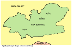
Map of the Agin-Buryat_Autonomous_Okrug.
Agin-Buryat Autonomous Okrug was an autonomous okrug of Russia. The okrug was completely surrounded by Chita Oblast.
On March 1, 2008, the oblast and the okrug merged to form Zabaykalsky Krai. The territory of the former autonomous okrug is now administrated as Agin-Buryat Okrug of Zabaykalsky Krai.
References
- ↑ Президент Российской Федерации. Указ №849 от 13 мая 2000 г. «О полномочном представителе Президента Российской Федерации в федеральном округе». Вступил в силу 13 мая 2000 г. Опубликован: "Собрание законодательства РФ", №20, ст. 2112, 15 мая 2000 г. (President of the Russian Federation. Decree #849 of May 13, 2000 On the Plenipotentiary Representative of the President of the Russian Federation in a Federal District. Effective as of May 13, 2000.).
- ↑ Госстандарт Российской Федерации. №ОК 024-95 27 декабря 1995 г. «Общероссийский классификатор экономических регионов. 2. Экономические районы», в ред. Изменения №5/2001 ОКЭР. (Gosstandart of the Russian Federation. #OK 024-95 December 27, 1995 Russian Classification of Economic Regions. 2. Economic Regions, as amended by the Amendment #5/2001 OKER. ).
- ↑ Федеральная служба государственной статистики (Federal State Statistics Service) (2004-05-21). "Территория, число районов, населённых пунктов и сельских администраций по субъектам Российской Федерации (Territory, Number of Districts, Inhabited Localities, and Rural Administration by Federal Subjects of the Russian Federation)". Всероссийская перепись населения 2002 года (All-Russia Population Census of 2002) (in Russian). Federal State Statistics Service. Retrieved 2011-11-01.
- ↑ The density value was calculated by dividing the population reported by the 2010 Census by the area shown in the "Area" field. Please note that this value may not be accurate as the area specified in the infobox is not necessarily reported for the same year as the population.
- ↑ UTC+08:00
- ↑ Official on the whole territory of Russia according to Article 68.1 of the Constitution of Russia.
This article is issued from Wikipedia - version of the 10/28/2016. The text is available under the Creative Commons Attribution/Share Alike but additional terms may apply for the media files.