Agriculture Street Landfill
| Agriculture Street Landfill | |
|---|---|
| Superfund site | |
 | |
| Geography | |
| City | New Orleans |
| State | Louisiana |
| Coordinates | 29°59′20″N 90°2′31″W / 29.98889°N 90.04194°WCoordinates: 29°59′20″N 90°2′31″W / 29.98889°N 90.04194°W |
 Agriculture Street Landfill | |
| Information | |
| CERCLIS ID | LAD981056997 |
| Contaminants | Lead, arsenic, and PAHs |
| Progress | |
| Proposed | 08/23/1994 |
| Listed | 12/16/1994 |
| Construction completed | 04/02/2002 |
| Partially deleted | 06/15/2000 |
| List of Superfund sites | |
The Agriculture Street Landfill was a dump in New Orleans, Louisiana. The area was later developed for residential use, with unfortunate environmental consequences. It became a Superfund cleanup site.
History
A city dump
This area in the Upper Ninth Ward of New Orleans was swampy low ground when it began to be used as a dump in 1909. The landfill became one of the area's main dumps for both residential and industrial waste. It often caught fire, with flames and smoke visible for a good distance away, and got the local nickname Dante's Inferno. The dump was first closed in 1952, but continued as a sanitary landfill site to the end of the decade. It reopened in the aftermath of Hurricane Betsy, and much debris from that storm was deposited on site. It was officially reclosed in 1966, although reports indicate that dumping continued for another year. The landfill site was then covered with ash from city incinerators and compacted by bulldozers.
Redevelopment
Starting in 1978, the old dump site was covered with sand and soil then redeveloped as a residential neighborhood, with 67 single-family homes, 225 townhouses (majority public housing), a 128-unit apartment complex, Moton Elementary School, and a small shopping plaza. Three residential developments - Press Park (the townhouses), Gordon Plaza (the single-family homes), and Liberty Terrace (the apartment building) - were built over the old landfill area.
The redevelopment project was championed by then mayor Dutch Morial as an opportunity for low-income African-Americans to qualify for home ownership. Along with the City of New Orleans led by Morial, additional sponsors of the redevelopment project included former U.S. Representative William J. Jefferson, New Orleans City Councilman Johnny Jackson, the Housing Authority of New Orleans, the New Orleans school board, and HUD.
Problems
Complaints of trash working its way up to the surface and health problems by area residents first prompted Environmental Protection Agency investigations in 1986. The area was initially judged not worthy of federal remedy and no further remedial action was planned by the EPA. In 1991, the US Centers for Disease Control revised the national levels for lead in blood from 25 ugm/DL to 10 ugm/DL, prompting new concern for environmental lead exposure. Residents continued finding old trash just below the surface when trying to plant gardens or erect fences, and anecdotal evidence of health problems including abnormally high rates of cancer became common (though the ATSDR found, in September 1997, that statistically higher breast cancer rates in the area were not related to the site). People in the area petitioned for retesting in 1993, and the site was placed on the National Priorities List as a cleanup site the following year. Investigations showed that the actual amount of soil placed over the landfill before redevelopment was much thinner than had been claimed.
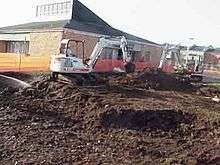
Remedial work
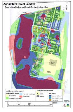
EPA supervised cleanup included closing Morton Elementary, and on residential land removing two feet of soil, putting down a geotextile barrier, then topping it with two feet of new clean soil. In April 2001 it was announced to be 99% complete. Many area homeowners and residents have petitioned for being moved elsewhere, with the backing of Congressman Bill Jefferson, but they have not succeeded in getting funds provided.
After Hurricane Katrina
Flooding in the aftermath of Hurricane Katrina disrupted this area (see: Effect of Hurricane Katrina on New Orleans), with storm surge funneled by the Mississippi River-Gulf Outlet Canal flooding into this neighborhood in 2005. There are concerns that the flooding has released additional toxins in the area. "Press Park", a 56 townhouse housing complex in the area, has been found contaminated with benzopyrene at levels some 50 times EPA health screening level, and remains fenced off as of April 2010.[1]
See also
References
External links
| Wikimedia Commons has media related to Agriculture Street Landfill. |
- Agriculture Street Landfill on The Agency for Toxic Substances and Disease Registry (ATSDR) site
- Agriculture Street Landfill on UMich.edu