Agronomía
| Agronomía | ||
|---|---|---|
| Barrio | ||
|
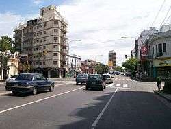
San Martin Avenue, Agronomia's southern limit | ||
| ||
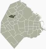
 Location of Agronomía within Buenos Aires | ||
| Country |
| |
| Autonomous City | Buenos Aires | |
| Comuna | C15 | |
| Important sites | Faculty of Agronomy and Veterinary Science | |
| Area | ||
| • Total | 2.1 km2 (0.8 sq mi) | |
| Population | ||
| • Total | 13,963 | |
| • Density | 6,600/km2 (17,000/sq mi) | |
| Time zone | ART (UTC-3) | |
| Day | September 25 | |
Agronomía is a barrio or district in the centre part of Buenos Aires city, Argentina. It gets its name from the Facultad de Agronomía (Agronomy School) of the University of Buenos Aires, located there. Its boundaries are Avenida San Martín, Campana, Avenida Salvador María del Carril, Avenida de los Constituyentes, and Avenida Chorroarín.
Parque Chas was previously a part of Agronomía, but was awarded barrio status in December 2005.
History
The fields were originally property of the Society of Jesus, and they were called Chacra de los jesuitas. When this religious order was expelled in 1769, these fields were taken from the Society of Jesus, and expropriated into the government's control. The government then gave them to the Real Colegio de San Carlos and its successors, one of them being Colegio Nacional de Buenos Aires. The first generations stayed there on vacation, for this reason it was known as Chacarita de los Colegiales.
At the end of the 19th century a park was built on these lands. In 1901 the Executive Branch of the government gave 185 hectares (460 acres) for the construction of the park, but 30 of those hectares were to be used for the Estación Agronómica con Granja Modelo (Agronomic Station and Model Farm) and the Escuela de Agricultura (Agricultural School), an educational institution necessary for the agro-export driven development model that the government was following at the time.
_-_UBA.jpg)
The neighbourhood was then formed around the park, which carried a series of names until de Agronomía (of Agronomy) was settled on. The Estación Agronómica (Agronomic Stataion) also experienced a change of name, becoming the Instituto Superior de Agronomía y Veterinaria (Superior Institute of Agronomy and Veterinarian Science).
The Institute was founded on September 25, 1904, and five years later became the Facultad de Agronomía y Veterinaria (Faculty of Agronomy and Veterinary Sciences) of the Universidad de Buenos Aires. In 1984, the two parts of the Faculty split, resulting in the creation of the School of Agronomy and the School of Veterinary Sciences.
Notable Buildings
In the neighbourhood, there are two major Faculties of the immense University of Buenos Aires, the School of Agronomy and the School of Veterinary Sciences. On the campus of the School of Agronomy there is the Villa Ortúzar Meteorological Station, part of the National Meteorological Service of Argentina. On the campus of the School of Veterinary Science there are two museums, one of Anatomy and the other of Surgical Pathology. The School of Agronomy also contains the Agricultural Machinery Museum and a project titled "Del Campo a la Ciudad" (From the Countryside to the City), a 16 hectare farm used for educational purposes.
Another notable building is the former house of Julio Cortázar, a famous Argentine writer, who lived in an apartment at Artigas 3246. Currently, a street in the neighbourhood carries his name.
Coordinates: 34°36′S 58°29′W / 34.600°S 58.483°W


