Aiguille de Scolette
| Aiguille de Scolette Pierre Menue | |
|---|---|
 | |
| Highest point | |
| Elevation | 3,506 m (11,503 ft) [1] |
| Prominence | 1,069 m (3,507 ft) [2] |
| Parent peak | Aiguilles d'Arves[3] |
| Listing | Alpine mountains above 3000 m |
| Coordinates | 45°09′34″N 06°46′04″E / 45.15944°N 6.76778°ECoordinates: 45°09′34″N 06°46′04″E / 45.15944°N 6.76778°E [1] |
| Geography | |
 Aiguille de Scolette Pierre Menue Location in the Alps | |
| Location |
Rhône-Alpes, France Piedmont, Italy |
| Parent range | Cottian Alps |
| Climbing | |
| First ascent | 1875 by Martino Baretti |
| Easiest route | from Pelouse's pass |
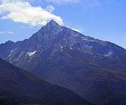
Aiguille de Scolette (in French) or Pierre Menue (in Italian) is a mountain of Savoie (F) and of the province of Turin (I). It lies in the Cottian Alps and has an elevation of 3,506 metres above sea level.
Geography
The mountain is the highest peak of Cottian Alps outside the Monviso area.
In the French subdivision of Western Alps it belongs to the Massif du Mont-Cenis.
Administratively the mountain is divided between the commune of Avrieux (F - north-west and north-east faces) and the comune of Bardonecchia (I - southern face).
On its Italian side at 1,979 metres above sea level stands the artificial lake of Rochemolles while on the French side is situated the small lake of Scolette (2686 metres).
Access to the summit
The easiest route for the summit starts from Pelouse's pass, which connects Avrieux and Bardonecchia, and follows the SW ridge and then the NW face of the mountain.[4]
Notes
- 1 2 Géoportail of Institut Géographique National
- ↑ Peakbagger.com, Peakbagger
- ↑ key col: col de la Vallée Etroite (2437 m)
- ↑ Aruga, Roberto; Pietro Losana; Alberto Re (1985). Alpi Cozie settentrionali. Guida ai monti d'Italia (in Italian). Club Alpino Italiano. pp. 283–284.
Maps
- Italian official cartography (Istituto Geografico Militare - IGM); on-line version: www.pcn.minambiente.it
- French official cartography (Institut Géographique National - IGN); on-line version: www.geoportail.fr
- Istituto Geografico Centrale: Carta dei sentieri e dei rifugi 1:50.000 scale n.1 Valli di Susa Chisone e Germanasca and 1:25.000 scale n.104 Bardonecchia Monte Thabor Sauze d'Oulx