AirRail Link

The AirRail Link is a people mover linking Birmingham Airport with Birmingham International railway station and the National Exhibition Centre (NEC), in the United Kingdom. The current system, originally known as SkyRail, replaced the earlier Birmingham Maglev system in 2003.
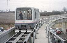
The Birmingham Maglev was opened in 1984 and was the first commercial Maglev transport system in the world. The system was fully automated and used an elevated concrete guideway, much of which has been reused for the current AirRail Link system.
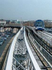
The current system is a fully automated cable-hauled system that takes passengers from the high-level railway station concourse, over a dual carriageway and into the terminal buildings. It has a length of 585 metres (1,919 ft), is free to use, and handles three million passengers per year.[1] During the day, the trains run every few minutes each way. At off-peak times, trains operate on demand, and to facilitate this, a button labelled "DEMAND" must be pressed by the prospective passenger.
Maglev
Initial feasibility studies for a link from the airport to the railway station and exhibition centre were started in 1979 by the owners of the airport at that time, West Midlands County Council. The selected solution was based on experimental work commissioned by the British government at the British Rail Research Division laboratory at Derby.
Contracts were awarded in 1981 to a consortium involving GEC, Balfour Beatty, Brush Electrical Machines and Metropolitan Cammell under the name "People Mover Group", along with John Laing plc. The carriages were manufactured by MetroCammell at their Washwood Heath plant in Birmingham.[2] The system was opened on 16 August 1984.[3]
As built, the length of the track was 600 metres (2,000 ft), and trains "flew" at an altitude of 15 millimetres (0.59 in). The line operated successfully for nearly eleven years, but obsolescence problems with the electronic systems, and a lack of spare parts, made it unreliable in its later years. The system closed in July 1995 when an investigation concluding the cost of reinstating and maintaining the Maglev to be too high. Initially the cars for the Maglev were stored by the airport owners, Birmingham International Airport Ltd., on the airport site.[3][4]
After closure, the original guideway lay dormant and a temporary shuttle bus service was operated until development of a suitable replacement was found. The guideway was reused in 2003 when the replacement cable-hauled SkyRail people mover was opened.[5]
One of the Maglev carriages, as well as a model of the system, Carriage Three can be found in the National Railway Museum in York. Another carriage was put up for sale in an auction on eBay in late 2010 after lying unused at the airport since the system's closure. Carriage No. 2 was sold for £25,100 with the proceeds going to two charities[6][7][8][9] and now resides with a private buyer in Warwickshire.[10] Carriage One resides at Railworld.
Replacement
The replacement project was started on 30 March 2001 and completed on 7 March 2003 with the first day of public operation. The project contract cost £11 million.[11]
The current AirRail Link is a cable-propelled double shuttle system. It is built on top of the previous Maglev guideway, slightly shortened by an extension of the railway station concourse to accommodate a low-level bus station. It uses the Cable Liner technology from DCC Doppelmayr Cable Car (DCC), and has two independent rope-hauled parallel tracks and a two-car passenger unit operating on each track.
The Birmingham Airport Link was DCC's first airport system and replaced the temporary bus service that had been operating since 1995. The new system has motivated passengers travelling to the airport to leave their cars at home and use public transportation.[1][5]
The 585 m-long (1,921 ft) AirRail Link takes travellers from the public transportation interchange to the airport check-in in 90 seconds. It is a dual track shuttle with two stations, that consists of two trains, each of two cars, operating independently at a speed of 36 kilometres per hour (22 mph). The trains operate at a minimum headway of 120 seconds, consisting of a dwell time at each station of 30 seconds and a journey time of 90 seconds. The individual cars carry 27 passengers at 0.33 square metres (3.6 sq ft) per person, thus giving a capacity of 54 passengers per train.[12]
Incidents
- On The 24th October A Faulty Malfunction With The Cables Failed To Move The Birmingham Airport Bound Service So The Other One Arrived First So The Service Can Be Reset.
See also
- LINK Train, a 7 car long airport system using the same technology in Toronto, Canada
- Airport Shuttle Mexico, airport system using the same technology in Mexico
- Free public transport
References
- 1 2 "References: AirRail Shuttle Birmingham International Airport Birmingham, UK". DCC Doppelmayr Cable Car. Retrieved 16 July 2008.
- ↑ "Birmingham Airport's old Maglev carriage to be sold". BBC News Online. 17 November 2010. Archived from the original on 18 November 2010. Retrieved 28 November 2010.
- 1 2 Hansard, House of Commons Hansard Written Answers for 26 May 1999 (pt 8): Passenger Transit System, 1999-05-26.
- ↑ Birmingham Mail, New plan aims to bring the Maglev back, 2006-09-01.
- 1 2 "Birmingham International Airport People Mover". Arup. Retrieved 11 July 2008.
- ↑ "Maglev up for sale on ebay". Birmingham Mail. 18 November 2010. Retrieved 18 November 2010.
- ↑ "Carriage from Birmingham Airport's gliding Maglev train sells for £25,100". Birmingham Mail. 27 November 2010. Retrieved 27 November 2010.
- ↑ "£25k deal for Maglev". Express & Star. 27 November 2010. Retrieved 27 November 2010.
- ↑ "Birmingham Airport's old Maglev carriage sold on eBay". BBC News Online. 28 November 2010. Retrieved 28 November 2010.
- ↑ http://www.obsessionistas.co.uk/news/?currentPage=12
- ↑ "BHX 2000 - Today". BHX.
- ↑ References. DCC Doppelmayr Cable Car GmbH. 2008. p. 5.
External links
| Wikimedia Commons has media related to AirRail Link. |
- Air-Rail Link, Birmingham Airport.
- DCC Doppelmayr Cable Car, designer's website
- Doppelmayr/Garaventa Group, parent company of DCC
- Photograph of a Birmingham Maglev car on Flickr
Coordinates: 52°27′08″N 1°43′46″W / 52.4522°N 1.7294°W