Aisne (river)
| Aisne | |
|---|---|
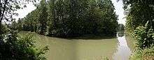 The Aisne near the village of Soupir | |
| Country | France |
| Basin | |
| Main source |
Champagne-Ardenne 48°56′44″N 05°10′46″E / 48.94556°N 5.17944°E |
| River mouth |
Oise 49°26′1″N 2°50′49″E / 49.43361°N 2.84694°ECoordinates: 49°26′1″N 2°50′49″E / 49.43361°N 2.84694°E |
| Progression | Oise→ Seine→ English Channel |
| Basin size | 7,752 km2 (2,993 sq mi) |
| Physical characteristics | |
| Length | 356 km (221 mi) |
| Discharge |
|
The Aisne (French: [ɛn]) is a river in northeastern France. It is a left tributary of the Oise. It gave its name to the French department of Aisne. It was known in the Roman period as Axona.
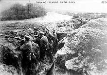
It rises in the forest of Argonne, at Rembercourt-Sommaisne, near Sainte-Menehould. It flows north and then west before joining the Oise near Compiègne. The Aisne is 356 kilometres (221 mi) long.[1] Its main tributaries are the Vesle, the Aire and the Suippe. Three bitter battles of World War I were fought into the valleys of the Aisne.
Places along the river
Departments and towns along the river include:
Navigation
Small boats can travel much of the length of the river. Canals join the Aisne to the Seine and Meuse rivers. In the small-capacity network of waterways, the Aisne and the Canal latéral à l'Aisne (Aisne lateral canal) give access to the agricultural towns of Soissons and Vailly-sur-Aisne, both large exporters of cereals. The waterway also links Northwestern Europe to the small inland harbour of Reims, where metallurgical industries depend on inland waterways transport. The Aisne is connected to the rest of the network by the Oise, the Canal de l'Oise à l'Aisne the Canal des Ardennes and the Canal de l'Aisne à la Marne. (Source: NoorderSoft Waterways Database)
Canalized portion
A 57.1-kilometre (35.5 mi) [2] portion of the river, with 7 locks, has been canalized, from Vailly-sur-Aisne to Compiègne. It is the westernmost segment of the Aisne. At the western end, it terminates at the Canal latéral à l'Oise. At the eastern end, it continues into the Canal latéral à l'Aisne.[2]
En route
PK is continuation of numbering from Canal latéral à l'Aisne from east to west.[3]
- PK 51.5 begins with ending of Canal latéral à l'Aisne
- PK 64.5 Villeneuve-Saint-Germain
- PK 67 Soissons
- PK 79 Fontenoy
- PK 85 Vic-sur-Aisne
- PK 92 Couloisy
- PK 104.5 Choisy-au-Bac
- PK 108 Compiègne ends in T-junction with Canal latéral à l'Oise
See also
References
- ↑ Sandre. "Fiche cours d'eau (H1--0200)".
- 1 2 Voies Navigables France Itinéraires Fluviaux. Editions De L'Ecluse. 2009. ISBN 978-2-916919-21-8.
- ↑ Jefferson, David (2009). Through the French Canals. Adlard Coles Nautical. p. 275. ISBN 978-1-4081-0381-4.
- World Book encyclopedia 1988
| Wikimedia Commons has media related to Aisne River. |