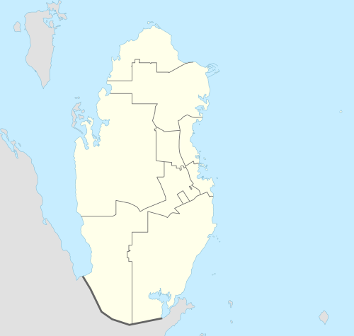
Al-Shahaniya
| Al Shahaniya الشحانية | |
|---|---|
| Municipality | |
 Al Shahaniya | |
| Coordinates: QA 25°22′20″N 51°12′17″E / 25.37222°N 51.20472°ECoordinates: QA 25°22′20″N 51°12′17″E / 25.37222°N 51.20472°E | |
| Country | Qatar |
| Municipality | Al Shahaniya |
| Area | |
| • Total | 3,299 km2 (1,274 sq mi) |
| Population (2015) | |
| • Total | 187,571 |
| • Density | 57/km2 (150/sq mi) |
Al Shahaniya (also Ash Shahaniya) is a municipality (3299 km2) and urban locality (city) by the same name (287 km2) in Qatar, formerly in the municipality of Al Rayyan, but now independent municipality.[1] Locality was delimited in 1988 by Law No. 22.[2] In 2014, the cabinet ratified a draft amending some provisions (municipality) to the 1988 law.[3]
Etymology
The city derives its name from a plant known locally as 'sheeh' which was valued for its anti-inflammatory effects.[4]
History
In J.G. Lorimer's Gazetteer of the Persian Gulf, Al-Shahaniya is described as a 'Bedouin camping ground' with a 35-feet deep masonry well yielding good water in 1908.[5]
Sports
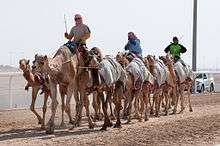
Al-Shahania Sports Club is based in the city. Qatar's main camel racetrack is also located in the city.[6]
Demographics
As of the 2010 census, the settlement comprised 3,440 housing units[7] and 1,430 establishments.[8] There were 35,393 people living in the settlement, of which 81% were male and 19% were female. Out of the 35,393 inhabitants, 86% were 20 years of age or older and 14% were under the age of 20.[9]
Employed persons made up 82% of the total population. Females accounted for 10% of the working population, while males accounted for 90% of the working population.[9]
| Year | Locality Pop | Muni Pop (Backdated) |
|---|---|---|
| 1986[10] | 4,654 | |
| 1997[11] | 6,852 | 19,328 |
| 2004[12] | 8,380 | 23,445 |
| 2010[1] | 35,393 | 62,962 |
| 2015 | 138,509 | 187,581[13] |
References
- 1 2 "2010 population census" (PDF). Qatar Statistics Authority. Retrieved 29 June 2015.
- ↑ "Law No. 22 of 1988 On the Delimitation of the City of Ash-Shahaniyah". almeezan.qa. Retrieved 1 July 2015.
- ↑ "Cabinet ratifies law on Al Shahaniya borders". Qatar Tribune. 18 September 2014. Retrieved 1 July 2015.
- ↑ Heba Fahmy (4 April 2015). "What's in a name? The meanings of Qatar districts, explained". Doha News. Retrieved 5 October 2015.
- ↑ "'Gazetteer of the Persian Gulf. Vol. II. Geographical and Statistical. J G Lorimer. 1908' [1528] (1643/2084)". Qatar Digital Library. Retrieved 27 July 2015.
- ↑ "Sports". Qatar Tourism Authority. Retrieved 1 July 2015.
- ↑ "Housing units, by type of unit and zone (April 2010)" (PDF). Qatar Statistics Authority. Retrieved 7 August 2015.
- ↑ "Establishments by status of establishment and zone (April 2010)" (PDF). Qatar Statistics Authority. Retrieved 7 August 2015.
- 1 2 "Geo Statistics Application". Ministry of Development Planning and Statistics. Retrieved 7 August 2015.
- ↑ "1986 population census" (PDF). Qatar Statistics Authority. Retrieved 2 July 2015.
- ↑ "1997 population census" (PDF). Qatar Statistics Authority. Retrieved 2 July 2015.
- ↑ "2004 population census". Qatar Statistics Authority. Retrieved 1 July 2015.
- ↑ http://citypopulation.de/Qatar.html
Census designated areas
| |
Unincorporated or abandoned areas
|