Alabama State Route 73
| ||||
|---|---|---|---|---|
 | ||||
| Route information | ||||
| Maintained by ALDOT | ||||
| Length: | 11.219 mi[1] (18.055 km) | |||
| Major junctions | ||||
| South end: |
| |||
| North end: |
| |||
| Location | ||||
| Counties: | Jackson | |||
| Highway system | ||||
| ||||

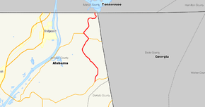
State Route 73 (SR 73), is a 11.219-mile-long (18.055 km) state highway in the U.S. state of Alabama. The southern terminus of the highway is at an intersection with SR 71 in Higdon north to the Tennessee state line, where it becomes Tennessee State Route 377 (SR 377). SR 73 travels through rural areas in eastern Jackson County, serving the community of Bryant.
The SR 73 designation was first used for present-day CR 29 between Piedmont in Calhoun County and Forney in Cherokee County, existing in the 1930s and 1940s. In the 1950s, SR 207 was briefly assigned to the road between Higdon and Bryant before it received the SR 73 designation. SR 73 was extended in the 1980s north to the Tennessee state line to connect to SR 377.
Route description
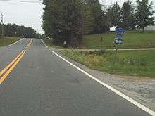
SR 73 begins at an intersection with SR 71 in the community of Higdon, heading north on a two-lane undivided road. The highway heads through rural areas of farms and woods with some homes, curving to the northwest. The highway heads north again as it crosses under several power lines radiating from the Widows Creek Power Plant along the Tennessee River. SR 73 continues northeast past homes and businesses in the Bryant area on top of Sand Mountain prior to going north through more forested areas with a few rural homes. The highway travels through a mix of farm and woodland before it turns east into forests. SR 73 makes a sharp curve north again to traverse Sand Mountain as it comes to the Tennessee state line. At this point, the road continues into Tennessee as Tennessee State Route 377 (SR 377), which ascends Sand Mountain to end at SR 156, east of South Pittsburg, Tennessee.[1][2][3]
History
The SR 73 designation was first assigned in 1934 to an unimproved road connecting SR 74 in Piedmont and SR 62 in Forney, traveling through Spring Garden and Rock Run.[4] By 1948, this road was removed from the state highway system, becoming CR 29 in Calhoun and Cherokee counties by 1955.[5][6] What would become the current SR-73 south of Bryant became a part of SR-207 by 1955; at this time, the portion of road was a paved highway.[6] SR 207 was redesignated SR 73 by 1957.[7] By 1987, SR 73 was extended north from Bryant to the Tennessee state line.[8]
Major intersections
The entire route is in Jackson County.
| Location | mi[1] | km | Destinations | Notes | |
|---|---|---|---|---|---|
| Higdon | 0.000 | 0.000 | Southern terminus | ||
| Bryant | 11.219 | 18.055 | Tennessee state line | ||
| 1.000 mi = 1.609 km; 1.000 km = 0.621 mi | |||||
See also
-
 U.S. Roads portal
 -
 Alabama portal
References
- 1 2 3 Milepost Map Jackson County, Alabama (PDF) (Map) (1999 ed.). Alabama Department of Transportation. Retrieved March 27, 2011.
- ↑ General Highway Map Jackson County, Alabama (PDF) (Map) (2006 ed.). Alabama Department of Transportation. Retrieved March 27, 2011.
- ↑ Google (March 27, 2011). "overview of Alabama State Route 73" (Map). Google Maps. Google. Retrieved March 27, 2011.
- ↑ State Road Map of Alabama (Map) (1934 ed.). General Drafting. Archived from the original on April 7, 2011. Retrieved March 27, 2011.
- ↑ Alabama Highways (Map) (1948 ed.). Alabama State Highway Department. Archived from the original on April 7, 2011. Retrieved March 27, 2011.
- 1 2 Alabama Highways (Map) (1955 ed.). Alabama State Highway Department. Archived from the original on September 18, 2009. Retrieved March 27, 2011.
- ↑ Official 1957 Alabama Highway Map (Map) (1957 ed.). Alabama State Highway Department. Archived from the original on July 20, 2011. Retrieved March 27, 2011.
- ↑ Official Alabama Highway Map, 1987-88 (Map) (1987 ed.). Alabama State Highway Department. Archived from the original on September 18, 2009. Retrieved March 27, 2011.
External links
![]() Media related to Alabama State Route 73 at Wikimedia Commons
Media related to Alabama State Route 73 at Wikimedia Commons