Alaskan Way Viaduct
| Alaskan Way Viaduct | |
|---|---|
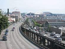 The Alaskan Way Viaduct, looking southeast | |
| Carries |
|
| Locale | Downtown Seattle, US |
| Characteristics | |
| Material | Concrete |
| History | |
| Construction end | April 4, 1953 |
| Statistics | |
| Daily traffic | 110,000 cars per day[1] |
 | |
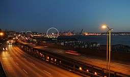
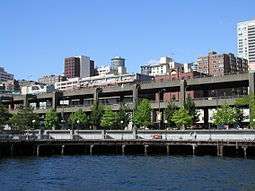
The Alaskan Way Viaduct is an elevated highway in Seattle, Washington built in three phases from 1949 through 1953 and opened on April 4, 1953. It features a double-decked elevated section of State Route 99 that runs along the Elliott Bay waterfront in the industrial district and downtown of Seattle. It is the smaller of the two major north–south traffic corridors through Seattle (the other being Interstate 5), carrying up to 110,000 vehicles per day.[1] The viaduct runs above the surface street, Alaskan Way, from S. Nevada Street in the south to the entrance of Belltown's Battery Street Tunnel in the north, following previously existing railroad lines.
The viaduct was damaged in the 2001 Nisqually earthquake. The initial phase of demolition and removal of the southern viaduct began on October 21, 2011.[2] Boring of the Alaskan Way Viaduct replacement tunnel by the tunnel boring machine "Bertha" began in 2013 and is anticipated to open in 2019;[3] the viaduct will be rebuilt to modern seismic standards for the industrial area south of downtown.
Earthquake concerns
The 1989 Loma Prieta earthquake destroyed the similarly designed Cypress Street Viaduct in Oakland, California with the loss of 42 lives.[4] The 2001 Nisqually earthquake damaged the viaduct and its supporting Alaskan Way Seawall and required the Washington State Department of Transportation (WSDOT) to invest US$14.5 million in emergency repairs. Experts give a 1-in-20 chance that the viaduct could be shut down by an earthquake within the next decade.[1] Since the Nisqually Earthquake occurred, semi-annual inspections have discovered continuing settlement damage.
Due to damage from continuing settlement, a group of researchers and faculty from the University of Washington urged the mayor of Seattle (in 2007) to close the viaduct within a four-year timeframe.[5]
Planned replacement
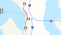
On January 12, 2009, the state of Washington, King County, the city of Seattle, and the Port of Seattle revealed that they had agreed to replace the viaduct with a four-lane, 2-mile (3.2 km) long underground tunnel.[6] The tunnel would have a south portal in SoDo, near CenturyLink Field, and a north portal near Thomas Street, north of the Battery Street Tunnel.[7]
The project is estimated to cost $4.25 billion, with the state, city, and county promising funding well short of the estimate.[6] The state will fund boring of the tunnels, while the city and county will fund surface street improvements and repairs to the Alaskan Way Seawall, which itself was damaged in the Nisqually earthquake.[6] The announcement did little to quell the long and heated debate over the viaduct's replacement, with several factions expressing their criticism over the tunnel decision.[6]
Boring of the tunnel by the tunnel boring machine "Bertha" began on July 30, 2013, with the roadway initially scheduled to open in December 2015.[8] Tunneling stopped on December 6, 2013, after the boring machine struck a steel pipe, which obstructed its path 1,083 feet (330 m) into the route. Investigations revealed that the machine had struck a pipe which had been installed in 2002 as a part of an exploratory well used to measure groundwater as part of the planning phases for the project. Boring resumed briefly on January 28–29, 2014, stopping again due to damage to the seal system which protects the machine's main bearing and damage to several of the butting blades.[9] This caused a two year delay as it was necessary to dig a 120-foot (37 m) vertical shaft recovery pit from the surface in order to access and lift the cutterhead for repair and partial replacement.[10]
Work was initially expected to resume by March 2015,[11] it was December 2015 before tunnelling recommenced.[12] 23 days later boring was halted again after a sinkhole developed on the ground in front of the machine,[13] but resumed a month later.[14]
The tunnel is not expected to be completed until 2019, four years behind schedule, and has incurred $223 million in cost overruns.[15]
In 2016, a citywide ballot measure attempted to build an elevated park along the waterfront after the demolition of the viaduct, utilizing a portion of the existing structure. The attempt failed, with more than 80 percent of voters in Seattle rejecting the measure.[16]
Route description
Heading northbound on State Route 99, the viaduct begins about a mile (1600 m) north of the First Avenue South Bridge, passing over the west end of the Industrial District. Just south of Safeco Field, at Massachusetts Street, the bridge shifts from a side-by-side alignment to the double-deck alignment commonly associated with the Alaskan Way Viaduct, with northbound traffic on the upper deck and southbound traffic on the lower deck. Then, at approximately Pike Street, the bridge reverts to a side-by-side alignment for about ½ mile (800 m) until the viaduct's north end at the entrance to the Battery Street Tunnel.[17]
Entrances and exits
| Mile | Entrances | Exits | Destinations |
|---|---|---|---|
| 28.91 | southbound | northbound | Spokane Street – West Seattle |
| 28.91 | northbound | southbound | West Seattle Bridge/Harbor Island |
| 30.75 | northbound | southbound | 1st Avenue S./Safeco Field/Qwest Field/Colman Dock |
| 31.30 | southbound | northbound | Seneca Street/Downtown |
| 31.95 | northbound and southbound | northbound and southbound | Western Avenue/Belltown |
| 32.44 | northbound | southbound | Denny Way/South Lake Union |
-
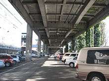
The view beneath the viaduct, facing south
-
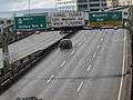
Western Ave Exit to Belltown
Cutout
Near the northern terminus of the Alaskan Way Viaduct, the southbound section of the viaduct is cut away to make room for the Seattle Empire Laundry building that was there at the time of construction. Although the structure of the building extends only a few inches into the viaduct, it is nonetheless unusual to see part of a building in the road, on a bridge, 50 ft (15 m) in the air.
See also
- West Side Highway, a former elevated freeway along the West Side waterfront in Manhattan that was partially replaced with an at-grade boulevard.
- Gardiner Expressway, an elevated freeway in Toronto with similar future plans.
- Embarcadero Freeway, a former elevated freeway along the waterfront in San Francisco that was demolished.
- John F. Fitzgerald Expressway, a former elevated freeway in Boston (Interstate 93) that was rerouted into a 3.5-mile (5.6 km) tunnel.
References
- 1 2 3 WSDOT Projects: Alaskan Way Viaduct and Seawall Replacement
- ↑ Gutierrez, Scott (October 22, 2011). "Alaskan Way Viaduct closure, demolition begin". seattlepi.com. Retrieved November 25, 2011.
- ↑ Seattle Tunnel Partners (June 1, 2016). "Seattle Tunnel Partners monthly schedule – May 2016" (PDF). Washington State Department of Transportation. Retrieved July 21, 2016.
- ↑ "Cypress Viaduct Freeway". Archived from the original on July 7, 2009.
- ↑ Miles, Scott; Montgomery, David R.; Beyers, Bill (March 2, 2006). "Shut down the viaduct". The Seattle Times. Retrieved July 21, 2016.
- 1 2 3 4 Garber, Andrew (January 13, 2009). "Tunnel in place of viaduct: A deal, but how to pay?". The Seattle Times. Retrieved January 13, 2009.
- ↑ "Alaska Way VIaduct and Battery Street Tunnel HAER WA-184" (PDF). Washington State Department of Transportation. Retrieved 26 March 2014.
- ↑ Lindblom, Mike (July 30, 2013). "Bertha's excavation mission beginning under downtown". The Seattle Times. Retrieved July 21, 2016.
- ↑ "Feb. 7 update: Two factors contributed to tunnel stoppage". Washington State Department of Transportation. February 7, 2014. Retrieved July 21, 2016.
- ↑ Lindblom, Mike (January 30, 2015). "Bertha's repair pit reaches full depth of 120 feet". The Seattle Times. Retrieved July 21, 2016.
- ↑ Cohen, Aubrey (April 21, 2014). "State: Bertha to get back to work by next March". Seattle Post-Intelligencer. Retrieved July 21, 2016.
- ↑ Lindblom, Mike (December 22, 2015). "Bertha back on the move after 2 years of delays". The Seattle Times. Retrieved July 21, 2016.
- ↑ Lindblom, Mike (January 14, 2016). "Inslee orders tunnel dig halted as soil sinks above Bertha". The Seattle Times. Retrieved July 21, 2016.
- ↑ Lindblom, Mike (February 23, 2016). "She's ba-ack! Yes, Bertha's on the move once again". The Seattle Times. Retrieved July 21, 2016.
- ↑ Lindblom, Mike (July 21, 2016). "Bertha's woes grind on: more delay, higher cost for Highway 99 tunnel". The Seattle Times. Retrieved July 21, 2016.
- ↑ Madej, Patricia (August 2, 2016). "Voters soundly reject elevated waterfront park for downtown Seattle". The Seattle Times. Retrieved August 3, 2016.
- ↑ "Bridges and Roadway Structures Other Roadway Structures". City of Seattle. Retrieved 26 March 2014.
Bibliography
- Gilmore, Susan (September 8, 2006). "Two views of the viaduct" (article links to videos which require RealPlayer 10.5). Seattle Times. Retrieved 2006-09-10.
- Gilmore, Susan (August 9, 2006). "State offers 3 decidedly different designs for viaduct". Seattle Times. Retrieved 2006-08-15.
- Gilmore, Susan (2006-08-02). "Idea of fixing viaduct seen as having merit but problems as well". Seattle Times. Retrieved 2006-08-02.
- Gilmore, Susan (July 25, 2006). "What will happen if viaduct closes? Study takes a look". Seattle Times. Retrieved 2006-07-25.
- Lange, Larry (May 3, 2006). "A Longer shelf life for the viaduct". Seattle P.I. Retrieved 2006-06-24.
- "Seattle's Little Dig". Seattle Weekly. April 19, 2006. Archived from the original on August 14, 2009. Retrieved 2006-06-24.
- "MorePerfect.org collected news stories". MorePerfect.org. Archived from the original on August 14, 2009.
- "Viaduct Open to Cars Today." Viaduct Open to Cars Today [Seattle] 05 Apr. 1953: n. pag. 1 Rpt. in The Seattle Post Intelligencer. Seattle: n.p., 1953.
- "Alaska Way VIaduct and Battery Street Tunnel HAER WA-184" (PDF). Washington State Department of Transportation. Retrieved 26 March 2014.
External links
| Wikimedia Commons has media related to Alaskan Way Viaduct. |
- SR 99 – Alaskan Way Viaduct & Seawall Replacement Project
- HistoryLink Alaskan Way Viaduct essays by Jennifer Ott:
- Alaskan Way Viaduct, Part 1: Early Transportation Planning (September 13, 2011)
- Alaskan Way Viaduct, Part 2: Planning and Design (October 27, 2011)
- Alaskan Way Viaduct, Part 3: Building the Viaduct (December 3, 2011)
- Alaskan Way Viaduct, Part 4: Replacing the Viaduct (December 19, 2011)
- Seattle's Columbia Street on-ramp to the Alaskan Way Viaduct opens to traffic on February 1, 1966 (December 26, 2011)
- Alaskan Way Viaduct and Battery Street Tunnel (Historic American Engineering Record)
Coordinates: 47°36′14″N 122°20′18″W / 47.603986°N 122.338246°W