Albstadt
| Albstadt | ||
|---|---|---|
|
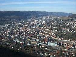
A view of Ebingen. | ||
| ||
 Albstadt | ||
Location of Albstadt within Zollernalbkreis district 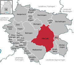
 | ||
| Coordinates: 48°12′43″N 09°01′26″E / 48.21194°N 9.02389°ECoordinates: 48°12′43″N 09°01′26″E / 48.21194°N 9.02389°E | ||
| Country | Germany | |
| State | Baden-Württemberg | |
| Admin. region | Tübingen | |
| District | Zollernalbkreis | |
| Government | ||
| • Mayor | Klaus Konzelmann (FW) | |
| Area | ||
| • Total | 134.41 km2 (51.90 sq mi) | |
| Population (2015-12-31)[1] | ||
| • Total | 44,431 | |
| • Density | 330/km2 (860/sq mi) | |
| Time zone | CET/CEST (UTC+1/+2) | |
| Postal codes | 72421–72461 | |
| Dialling codes | 07431, 07432, 07435 | |
| Vehicle registration | BL | |
| Website | www.albstadt.de | |

Albstadt (German pronunciation: [ˈalpʃtat]) is the largest city in the district of Zollernalbkreis in Baden-Württemberg, Germany. It is located on the Swabian Alb mountains, about halfway between Stuttgart and Lake of Constance.
Geography
Albstadt is spread across a variety of hills and valleys, its elevation ranges between 614 m (2,014 ft) above sea level and 966 m (3,169 ft). One valley is the river Schmiecha, a left-hand tributary of the Danube, a second valley is the river of upper Eyach, a tributary of the Neckar.
To Albstadt belongs also the Raichberg hill in the north, on which there is the Raichberg Transmitter and an observation tower located. South of Albstadt is the Heuberg Military Training Area.
History
Settlement in the region dates back to at least the Iron Age. A Hallstatt cemetery in Albstadt was excavated by amateur archaeologists in the late nineteenth century and revealed a wide range of pottery and metal artefacts. Known as the 'Degerfeld Barrow' cemetery, a substantial collection was built up by the local antiquary Hyronimus Edelmann that was eventually deposited in the British Museum.[2][3]
The districts Ebingen, Laufen, Lautlingen, Pfeffingen und Tailfingen were first mentioned in 793 in a document of the abbey St. Gallen. Ebingen received city rights around 1250 from the Hohenberg ducal family.
Albstadt consists of the following urban districts, which had been independent towns and merged to form Albstadt in 1975:

| Coat of Arms | | | | | | | | | |
|---|---|---|---|---|---|---|---|---|---|
| District | Ebingen | Tailfingen (Albstadt) | Onstmettingen | Truchtelfingen | Pfeffingen (Albstadt) | Lautlingen (Albstadt) | Laufen (Albstadt) | Margrethausen | Burgfelden |
| Population (2006) | 19.618 | 12.234 | 5.384 | 3.229 | 2.168 | 1.998 | 1.753 | 1.084 | 345 |
| Population (2007) | 19.339 | 12.091 | 5.314 | 3.223 | 2.131 | 1.987 | 1.753 | 1.087 | 338 |
| Population (2008) | 19.265 | 12.072 | 5.260 | 3.189 | 2.147 | 1.988 | 1.777 | 1.069 | 346 |
| Population (2009) | 19.196 | 11.895 | 5.194 | 3.210 | 2.074 | 1.942 | 1.764 | 1.046 | 382 |
| Population (2010) | 18.718 | 11.522 | 5.006 | 3.101 | 2.144 | 1.833 | 1.709 | 1.023 | 364 |
| Population (2011) | 18.584 | 11.500 | 4.957 | 3.108 | 2.048 | 1.821 | 1.699 | 1.025 | 361 |
| Population (2012) | 18.478 | 11.329 | 4.900 | 3.028 | 1.993 | 1.771 | 1.699 | 997 | 314 |
| Population (2014)[4] | 18.675 | 11.208 | 4.903 | 3.035 | 1.982 | 1.808 | 1.664 | 967 | 336 |
Economy
Most of the textiles industry (among them Hasana J. Hakenmüller) is gone today, leaving some monuments, like Villa Haux. However, one of the world's biggest makers of industrial needles, Groz-Beckert still resides there. Other prominent local companies include Mey (knitwear), Mettler Toledo (weighing systems) and a major part of Assa Abloy security systems (Eff-Eff Brand). Ebingen also hosts the technical and computer science faculties of Albstadt-Sigmaringen University with about 3,000 students (2014).
Number of inhabitants
- 1975: 50.772
- 1987: 46.369
- 1995: 49.463
- 2005: 46.505
- 2015: 44.431
Lord Mayors of Albstadt
- 1975–1991: Hans Pfarr (CDU)
- 1991–1999: Hans-Martin Haller (SPD)
- 1999–2015: Jürgen Gneveckow (CDU)
- since 2015: Klaus Konzelmann (Free voters Baden-Württemberg)
Sons and daughters of the town
- Gregor Dorfmeister (also known as Manfred Gregor; born 1929), journalist and writer
- Jürgen Gneveckow (born 1952 in Tailfingen), 1999-2015 mayor of Albstadt
- Walther Groz (1903–2000), born in Ebingen, producer, mayor of Ebingen
- Monika Herzig (born 1964), jazz musician and musicologist
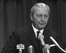
- Kurt Georg Kiesinger (1904–1988), lawyer and politician (CDU), Prime Minister of Baden-Württemberg (1958–1966) and Chancellor (1966–1969)
- Klaus Konzelmann (born 1963 in Truchtelfingen), police official and current mayor of Albstadt
Personalities who have worked on the ground
- Ignaz Anton Demeter (1773-1842), 1802-1808 first Parish Councilor in Lautlingen, 1836-1842 Archbishop of Freiburg.
- Otto Hahn (1879-1968), chemist, nuclear scientist, Nobel laureate. After the Kaiser Wilhelm Institute was bombed out in Berlin in the spring of 1944, he researched from June 1944 to April 1945 in Tailfingen.
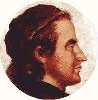
- Philipp Matthäus Hahn (1739-1790), pastor, designer and inventor, lived in Onstmettingen from 1764-1770
- Claus von Stauffenberg (1907-1944), officer, assassin on Adolf Hitler; spent parts of his youth in Lautlingen
- Berthold Schenk Graf von Stauffenberg (1905-1944), jurist, participant in the assassination attempt on Adolf Hitler; spent parts of his youth in Lautlingen
- Martin Schaudt (born 1958), dressage rider
External links
![]() Media related to Albstadt at Wikimedia Commons
Media related to Albstadt at Wikimedia Commons
References
- ↑ "Gemeinden in Deutschland nach Fläche, Bevölkerung und Postleitzahl am 30.09.2016". Statistisches Bundesamt (in German). 2016.
- ↑ Schwarzwaelder-bote website
- ↑ British Museum Collection
- ↑ http://www.albstadt.de/stadt/zahlendatenfakten (in German) Population numbers
Towns and municipalities in Zollernalb district | ||
|---|---|---|