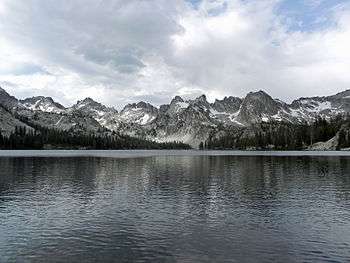
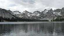
Alice Lake (Sawtooth Wilderness)
| Alice Lake | |
|---|---|
 Alice Lake | |
| Location | Blaine County, Idaho, United States |
| Coordinates | 43°56′35″N 114°56′28″W / 43.943°N 114.941°WCoordinates: 43°56′35″N 114°56′28″W / 43.943°N 114.941°W |
| Type | Glacial |
| Primary outflows | Creek to Pettit Lake |
| Basin countries | United States |
| Max. length | 0.72 mi (1.16 km) |
| Max. width | 0.23 mi (0.37 km) |
| Surface elevation | 8,602 ft (2,622 m) |
Alice Lake is an alpine lake in Blaine County, Idaho, United States, located high in the Sawtooth Mountains in the Sawtooth National Recreation Area. The lake is one of the largest in the Sawtooth Wilderness and is most easily accessed via the trailhead at Pettit Lake, accessed from State Highway 75 via Sawtooth National Forest road 208.[1][2]
The direct route to the lake begins at the trailhead at the end of the Pettit Lake campground. The trail distance is about 5.5 miles (9 km) to the lake and gains about 1,600 feet (490 m) in elevation. The trail requires five stream crossings, only the last of which has a bridge.
With a surface elevation of 8,602 feet (2,622 m) above sea level, Alice Lake can remain frozen into early summer. The lake is framed by the rocky peaks of the Sawtooth Mountains, to the east is El Capitan at 9,901 feet (3,018 m).
Alice Lake is with the Sawtooth Wilderness; wilderness permits are obtained at a registration box along the trail at the wilderness boundary, at the upstream end of Pettit Lake.
See also
- List of lakes of the Sawtooth Mountains (Idaho)
- Sawtooth National Forest
- Sawtooth National Recreation Area
- Sawtooth Range (Idaho)

References
- ↑ Sawtooth National Forest (Map) (2012 ed.). 1:126,720. Sawtooth National Forest, U.S. Forest Service.
- ↑ "Alice Lake". Geographic Names Information System. United States Geological Survey. Retrieved August 13, 2015.