All Saints Church, Blizne
All Saints Church in Blizne | |
|---|---|
 | |
| Basic information | |
| Location |
|
| Affiliation | Roman Catholicism |
| Status | active church |
| Architectural type | Gothic |
| Completed | before 1470 |
| Official name: Wooden Churches of Southern Lesser Poland | |
| Type | Cultural |
| Criteria | iii, iv |
| Designated | 2003 (27th session) |
| Reference no. | 1053 |
| State Party |
|
| Region | Europe |
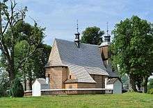
All Saints Church in Blizne - a Gothic, wooden church located in the village of Blizne from the fifteenth-century, which together with different churches is designated as part of the UNESCO Wooden Churches of Southern Lesser Poland.
The church in Blizne is one of the most notable heritage sites of wooden sacramental architecture in Poland, as one of the most notable wooden churches in Poland, the church is part of the Trail of Wooden Architecture in the Subcarpathian Voivodeship (Szlak Architektury Drewnianej).[1]
History
A unique church-parish complex situated on a hilltop, surrounded by ancient woodland. The wooden church has fortification structures, raised in the fifteenth or sixteenth-century (most likely prior to 1470), in the Gothic architectural style. The church's tower was built in the first half of the seventeenth-century, with the soboty (wooden undercut supported by pillars) deconstructed.[2]
Architecture
The church is built with the technology used to build a log house, built from fir planks. Initially, the church had a hook-block connection, characteristic of Lesser Poland architecture. A large bell tower is located to the west of the church, with hanging a starling. The dome of the church is covered with wood shingle. The church is surrounded by a garden with walled chapels.[3]
References
- ↑ "Wooden Churches of Southern Małopolska". UNESCO. Retrieved 12 March 2016.
- ↑ "UNESCO w Polsce". Ciekawe Miesca. Retrieved 12 March 2016.
- ↑ "INFORMACJA DLA TURYSTÓW O MOŻLIWOŚCI ZWIEDZANIA KOŚCIOŁA P. W. WSZYSTKICH ŚWIĘTYCH W BLIZNEM". Blizne. Retrieved 12 March 2016.
Coordinates: 49°45′04″N 21°58′29″E / 49.7511°N 21.9747°E