Anegada Passage
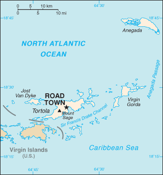
Map of the British Virgin Islands, with the Anegada Passage labeled at right
Anegada Passage is a strait in the Caribbean, at 18°22′41″N 63°50′15″W / 18.377986°N 63.837433°W. It separates the British Virgin Islands and the British ruled Sombrero Island of Anguilla. The threshold depths are 1800 and 1600 m; atlantic deep water from 1600 m level may therefore flow into the deep areas in the Caribbean Sea.
This article is issued from Wikipedia - version of the 3/2/2015. The text is available under the Creative Commons Attribution/Share Alike but additional terms may apply for the media files.