Antelope Canyon
| Antelope Canyon | |
|---|---|
| Tsé bighánílíní dóó Hazdistazí (Navajo) | |
|
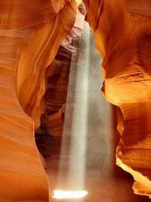
A beam of light in Upper Antelope Canyon | |
 ? | |
| Floor elevation | 3,704 ft (1,129 m)[1] |
| Long-axis length |
Upper Antelope Canyon: about 660 feet (200 m)[2] Lower Antelope Canyon: about 1,335 feet (407 m)[2] |
| Depth | about 120 feet (37 m)[3] |
| Geology | |
| Type | Sandstone slot canyon[3] |
| Geography | |
| Coordinates | 36°57′10″N 111°26′29″W / 36.9527664°N 111.4412683°WCoordinates: 36°57′10″N 111°26′29″W / 36.9527664°N 111.4412683°W[1] |
| Topo map | USGS Page |
| Population centers | Page |
Antelope Canyon is a slot canyon in the American Southwest. It is located on Navajo land east of Page, Arizona. Antelope Canyon includes two separate, scenic slot canyon sections, referred to individually as "Upper Antelope Canyon" or "The Crack"; and "Antelope Canyon" or "The Corkscrew".[2]
The Navajo name for Upper Antelope Canyon is Tsé bighánílíní, which means "the place where water runs through rocks." Lower Antelope Canyon is Hazdistazí (advertised as "Hasdestwazi" by the Navajo Parks and Recreation Department), or "spiral rock arches." Both are located within the LeChee Chapter of the Navajo Nation.[4]
Geology
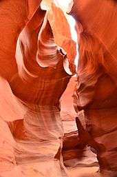
Antelope Canyon was formed by erosion of Navajo Sandstone,[2] primarily due to flash flooding and secondarily due to other sub-aerial processes. Rainwater, especially during monsoon season, runs into the extensive basin above the slot canyon sections, picking up speed and sand as it rushes into the narrow passageways. Over time the passageways eroded away, making the corridors deeper and smoothing hard edges in such a way as to form characteristic 'flowing' shapes in the rock.[3]
Flooding in the canyon still occurs. A flood occurred on October 30, 2006, that lasted 36 hours, and caused the Tribal Park Authorities to close Lower Antelope Canyon for five months.
Tourism and photography
Antelope Canyon is a popular location for photographers and sightseers, and a source of tourism business for the Navajo Nation. Private tour companies have been permitted to offer tours since 1987. It has been accessible by tour only since 1997, when the Navajo Tribe made it a Navajo Tribal Park. Photography within the canyons is difficult due to the wide exposure range (often 10 EV or more) made by light reflecting off the canyon walls.[5]

Upper Antelope Canyon
Upper Antelope Canyon is called Tsé bighánílíní, "the place where water runs through rocks" by the Navajo. It is the most frequently visited by tourists for two reasons. First, its entrance and entire length are at ground level, requiring no climbing. Second, beams (shafts of direct sunlight radiating down from openings in the top of the canyon) are much more common in Upper than in Lower. Beams occur most often in the summer months, as they require the sun to be high in the sky. Winter colors are a little more muted like the photo displayed here. Summer months provide two types of lighting. Light beams start to peek into the canyon March 20 and disappear October 7 each year.
Lower Antelope Canyon


Lower Antelope Canyon, called Hazdistazí, or "spiral rock arches" by the Navajo Indians, are located a few miles away. Prior to the installation of metal stairways, visiting the canyon required climbing along pre-installed ladders in certain areas. Even following the installation of stairways, it is a more difficult hike than Upper Antelope. It is longer, narrower in spots, and even footing is not available in all areas. At the end, the climb out requires several flights of stairs.
Despite these limitations, Lower Antelope Canyon draws a considerable number of photographers, though casual sightseers are much less common there than in Upper.
The lower canyon is in the shape of a "V" and shallower than the Upper Antelope. Lighting is better in the early hours and late morning.
Flash flood danger

Antelope Canyon is visited exclusively through guided tours, in part because rains during monsoon season can quickly flood the canyon. Rain does not have to fall on or near the Antelope Canyon slots for flash floods to whip through, as rain falling dozens of miles away 'upstream' of the canyons can funnel into them with little prior notice. On August 12, 1997, eleven tourists, including seven from France, one from the United Kingdom, one from Sweden and two from the United States, were killed in Lower Antelope Canyon by a flash flood.[6][7] Very little rain fell at the site that day, but an earlier thunderstorm had dumped a large amount of water into the canyon basin, 7 miles (11 km) upstream. The lone survivor of the flood was tour guide Francisco "Pancho" Quintana, who had prior swift-water training. At the time, the ladder system consisted of amateur-built wood ladders that were swept away by the flash flood. Today, ladder systems have been bolted in place, and deployable cargo nets are installed at the top of the canyon. At the fee booth, a NOAA Weather Radio from the National Weather Service and an alarm horn are stationed.[8]
Despite improved warning and safety systems, the risks of injuries from flash floods still exist. On July 30, 2010, several tourists were stranded on a ledge when two flash floods occurred at the Upper Antelope Canyon.[9] Some of them were rescued and some had to wait for the flood waters to recede.[10] There were reports that a woman and her 9-year-old son were injured as they were washed away downstream, but no fatalities were reported.[11]
Access
The road to Antelope Canyon is gated by the Navajo Nation and entry is restricted to guided tours led by authorized tour guides.[4]
References
- 1 2 "Antelope Canyon". Geographic Names Information System. United States Geological Survey. 27 June 1984. Retrieved 8 February 2015.
- 1 2 3 4 Kelsey, Michael R. (2011). Non-Technical Canyon Hiking Guide to the Colorado Plateau (6th ed.). Provo, Utah: Kelsey Publishing. p. 324. ISBN 978-0-944510-27-8.
- 1 2 3 "Antelope Canyon: Overview". Navajo Tours. Retrieved 8 February 2015.
- 1 2 "Lake Powell Navajo Tribal Park". Navajo Nation Parks & Recreation. Retrieved 8 February 2015.
- ↑ Martrès, Laurent (2006). A guide to the natural landmarks of Arizona. Photographing the Southwest (2nd ed.). Alta Loma, CA, USA: Graphie International. ISBN 978-0-916189-13-6.
- ↑ "Flash Flood Antelope Canyon". Retrieved 20 March 2006.
- ↑ "Antelope Canyon". Archived from the original on 17 March 2006. Retrieved 20 March 2006.
- ↑ Kramer, Kelly (2008). "Man vs. Wild". Arizona Highways. 84 (11): 23.
- ↑ "Hikers rescued from flooding in northern Arizona canyon". ABC News. 1 August 2010. Retrieved 1 May 2013.
- ↑ "Eight People Rescued from Antelope Canyon". NAS Today. 30 July 2010. Retrieved 1 May 2013.
- ↑ "Five injured in Antelope Canyon flash flood". AZ Daily Sun. 1 August 2010. Retrieved 1 May 2013.
External links
| Wikimedia Commons has media related to Antelope Canyon. |
- Antelope Canyon Navajo Tribal Park at Navajo Parks and Recreation Dept.
- Antelope Canyon Tours and information
- Antelope Canyon - Flash Flood
- Slot Canyons of the American Southwest - Antelope Canyon
- - Antelope Canyon Navajo Tours In Arizona