Antofagasta de la Sierra
For the town of the same name, see Antofagasta de la Sierra, Catamarca.
| Antofagasta de la Sierra | |
|---|---|
 | |
| Highest point | |
| Elevation | 4,000 metres (13,123 ft) (uncertain) [1] |
| Coordinates | 26°05′S 67°30′W / 26.08°S 67.50°WCoordinates: 26°05′S 67°30′W / 26.08°S 67.50°W [1] |
| Geography | |
 Antofagasta de la Sierra | |
| Parent range | Andes |
| Geology | |
| Age of rock | Holocene |
| Mountain type | Scoria cones |
| Last eruption | Unknown[1] |
Antofagasta de la Sierra is a volcanic field in Argentina. The main type of volcanic edifice in the area are scoria cones. The area contains the youngest vents in the whole of the Puna region of Argentina. It is considered by many authors that the cones in the field are only a few thousand years old, thus putting them firmly into the Holocene period. The field lies between the Salar de Antofalla volcanic field and the Cerro Galán caldera. The caldera lies west of Antofagasta de la Sierra and the other volcanic field to the east. The other prominent volcanic feature of the region, the peak Beltran, lies to the south-west of the field.
-

Antofagasta cone from the town
-
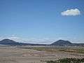
Alumbrera and Antofagasta cones
See also
References
- 1 2 3 "Antofagasta de la Sierra". Global Volcanism Program. Smithsonian Institution. Retrieved 2007-03-30.
This article is issued from Wikipedia - version of the 11/5/2016. The text is available under the Creative Commons Attribution/Share Alike but additional terms may apply for the media files.