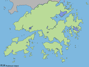
Ap Chau

Ap Chau (Chinese: 鴨洲; literally: "duck island"), also known as Robinson Island, with a size of 0.04 km² is an island in the Crooked Harbour, in the north-eastern New Territories of Hong Kong. It is located in Ap Chau Bay (鴨洲海) and is under the administration of North District. The island had 8 inhabitants as of June 2008.[1] Islets located close by include Ap Chau Pak Tun Pai, Ap Chau Mei Pak Tun Pai, Ap Lo Chun, Ap Tan Pai and Kau Tau Shek.
Robinson Island was named after Hercules Robinson, 1st Baron Rosmead, who was the 5th Governor of Hong Kong from 1859 to 1865.
History
The village on the island was set up by American preachers from the then Taiwan-based True Jesus Church in order to shelter fishermen and their families who converted to Christianity in the 1960s.[1] The single primary school on the island opened in 1958.[2] There used to be over 1,000 inhabitants called the Tanka, an originally non-Chinese ethnic minority who were mostly fishermen but most have moved over to cities in the United Kingdom[1][3] such as Newcastle upon Tyne,[4] Leicester, Sunderland, Elgin[2] and Edinburgh. The church on the island is still active.[5]
Features
Fresh water in Ap Chau is obtained from the mainland China using an underground pipe.
See also
References
- 1 2 3 "Ap Chau", HK magazine, Jun 19, 2008
- 1 2 Liu, Garland (1998). "The Role of the True Jesus Church in Communal Development of the Chinese People in Elgin, Scotland". In Sinn, Elizabeth. The Last Half Century of Chinese Overseas. Hong Kong: Hong Kong University Press. pp. 425–446. ISBN 978-962-209-446-8.
- ↑ History of the True Jesus Church in the United Kingdom
- ↑ Li Wei (1994). Three Generations, Two Languages, One Family: Language Choice and Language Shift in a Chinese Community in Britain. Multilingual Matters. p. 64. ISBN 978-1-85359-241-6.
- ↑ True Jesus Church. Church in Hong Kong Archived October 7, 2011, at the Wayback Machine.
External links
| Wikimedia Commons has media related to Ap Chau. |
Coordinates: 22°33′04.5″N 114°16′10″E / 22.551250°N 114.26944°E