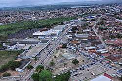
Arapiraca
| Arapiraca | |||
|---|---|---|---|
| Municipality | |||
 | |||
| |||
 Location of Arapiraca in the State of Alagoas | |||
 Arapiraca Location in Brazil | |||
| Coordinates: 9°45′07″S 36°39′39″W / 9.75194°S 36.66083°WCoordinates: 9°45′07″S 36°39′39″W / 9.75194°S 36.66083°W | |||
| Country |
| ||
| State | Alagoas | ||
| Mesoregion | Agreste Alagoano | ||
| Microregion | Arapiraca | ||
| Founded | 30 October 1924 | ||
| Government | |||
| • Mayor | Celia Rocha | ||
| Area | |||
| • Total | 351 km2 (136 sq mi) | ||
| Elevation | 264 m (866 ft) | ||
| Population (2010) | |||
| • Total | 214,006 (IBGE 2,010) | ||
| Demonym(s) | Arapiraquense | ||
| Postal code | 57300 | ||
| Area code(s) | (+55) 82 | ||
| Website | Official website (Portuguese) | ||


Arapiraca is a municipality located in the center of the Brazilian state of Alagoas, some 135 km (84 mi) from the state capital, Maceió. It was founded in 1924. As of 2010, it has a population of 214.006,[1] but IBGE estimated 227,640 inhabitants for 2013.
Arapiraca is the second largest city in Alagoas, and is known mostly for its production of tobacco, hence its nickname of "The Brazilian Tobacco Capital".
Neighboring municipalities
Clockwise from the north:
- north: Igaci
- north-north-east: Craíbas
- north-east: Coité do Nóia
- east: Limoeiro de Anadia
- south-east: Junqueiro
- south-south-east: São Sebastião
- south: Feira Grande
- south-west: Lagoa da Canoa
Sports
Agremiação Sportiva Arapiraquense, better known as ASA, is the city's football club. The club plays its home matches at the Estádio Municipal Coaracy da Mata Fonseca.
References
- ↑ IBGE – "Archived copy". Archived from the original on 2008-06-11. Retrieved 2008-06-11.
Capital: Maceió | ||
| Arapiraca | 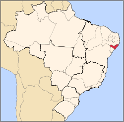 | |
| Palmeira dos Índios | ||
| Traipu | ||
| Litoral Norte Alagoano | ||
| Maceió | ||
| Mata Alagoana | ||
| Penedo | ||
| São Miguel dos Campos | ||
| Serrana dos Quilombos | ||
| Alagoana do Sertão do São Francisco | ||
| Batalha | ||
| Santana do Ipanema | ||
| Serrana do Sertão Alagoano | ||
This article is issued from Wikipedia - version of the 10/17/2016. The text is available under the Creative Commons Attribution/Share Alike but additional terms may apply for the media files.