Arizona State Route 84
| ||||
|---|---|---|---|---|
 | ||||
| Route information | ||||
| Maintained by ADOT | ||||
| Length: |
23.74 mi[1] (38.21 km) 22.87 mi (36.81 km) in main section 0.87 mi (1.40 km) in unsigned orphan section | |||
| Existed: | 1927 – present | |||
| Main Section | ||||
| West end: |
| |||
| East end: |
| |||
| Unsigned Orphan Section | ||||
| West end: |
| |||
| East end: |
| |||
| Highway system | ||||
| ||||

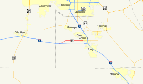
State Route 84, also known as SR 84, is a 23-mile (37 km) east–west highway in south-central Arizona, with its western terminus at Exit 151 of Interstate 8 and its eastern terminus at its junction with State Route 387 and State Route 287 in Casa Grande. An orphaned and unsigned section runs along the final 0.87 miles (1.40 km) of State Route 87 just north of Interstate 10 near Picacho.[2] Formerly, SR 84 ran between Tucson and Gila Bend, serving as the primary route for travelers to San Diego, California.[2]
Route description
The western terminus of SR 84 is located at exit 151 on I-8 in southern Arizona. From this interchange, it heads towards the northeast to an intersection with SR 347 which heads north to Maricopa. SR 84 continues towards the east from this intersection passing through Stanfield on its way to Casa Grande. The route reaches its eastern terminus at a junction with SR 287 and SR 387 in Casa Grande.[1][3]
History

_from_NE_3.JPG)
SR 84 was first designated in 1927 between Tucson and Picacho.[4] In 1928, SR 84 was extended from its western terminus to Gila Bend and was known as the Gila Bend Highway.[5][2] The route still carries that name in Casa Grande.[3] This westward extension allowed SR 84 to become a shortcut for US 80 traffic to bypass Phoenix.[2] At one point, SR 84 ran concurrently from Casa Grande to Tucson with former State Route 93 through Eloy (Jimmie Kerr Boulevard / Frontier Street) to a junction with State Route 87, before joining the current route of Interstate 10.[6] Sadly, the popularity and traffic along SR 84 meant its demise. Interstate 10 was constructed to Tucson, truncating SR 84 to Eloy. The original alignment of SR 84 is still maintained between Tucson and Eloy as a frontage road of I-10 under various names. Subsequently, SR 84 was truncated in the west to its current terminus at Exit 151 of Interstate 8 west of Casa Grande. I-8 replaced it from Casa Grande to Gila Bend. In 1997, a portion of SR 84 was decommissioned between SR 87 near Eloy and downtown Casa Grande, where it ends to this day. An unsigned orphan section of SR 84 exits southeast of Eloy, connecting SR 87 with I-10.[2]
This route serves as the only east–west thoroughfare in Stanfield, Arizona, though it has been largely supplanted as a major road by I-8.
Junction list
Main section
The entire route is in Pinal County.
| Location | mi[1] | km | Destinations | Notes | |
|---|---|---|---|---|---|
| | 155.10 | 249.61 | Western terminus | ||
| | 160.86 | 258.88 | |||
| Casa Grande | 177.97 | 286.41 | ADOT signs this as eastern terminus | ||
| 1.000 mi = 1.609 km; 1.000 km = 0.621 mi | |||||
Unsigned orphan section
| Location | mi[1] | km | Destinations | Notes | |
|---|---|---|---|---|---|
| | 195.20– 195.34 | 314.14– 314.37 | West end of SR 87 concurrency | ||
| | 196.07 | 315.54 | Eastern terminus; interchange with I-10; I-10 exit 211B; east end of SR 87 concurrency | ||
| 1.000 mi = 1.609 km; 1.000 km = 0.621 mi | |||||
References
- 1 2 3 4 Arizona Department of Transportation. "2013 ADOT Highway Log" (PDF). Retrieved January 22, 2016.
- 1 2 3 4 5 "Arizona 84". Arizona @ AARoads. AARoads. 8 October 2007. Retrieved 13 April 2015.
- 1 2 "Google Maps". Google, Inc. Retrieved 19 February 2014.
- ↑ W.B. Larls (1927). Arizona State Highway Commission Official State Routes and State Highways of the State of Arizona (Map). Arizona Highway Department. Retrieved May 6, 2015 – via AARoads.
- ↑ Staff. "ADOT Right-of-Way Resolution 1928-144". Arizona Department of Transportation. Retrieved 13 April 2015.
- ↑ Shell Oil Company; H.M. Gousha Company (1956). Shell Highway Map of Arizona (Map). 1:1,330,560. Chicago: Shell Oil Company. Retrieved March 31, 2015 – via David Rumsey Map Collection.