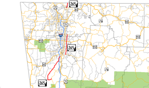
Arkansas Highway 265
| ||||
|---|---|---|---|---|
 | ||||
| Route information | ||||
| Maintained by AHTD | ||||
| Section 1 | ||||
| Length: | 19.70 mi[1] (31.70 km) | |||
| South end: |
| |||
| North end: |
| |||
| Section 2 | ||||
| Length: | 12.07 mi[1] (19.42 km) | |||
| South end: |
| |||
| North end: |
| |||
| Section 3 | ||||
| Length: | 3.33 mi[1] (5.36 km) | |||
| South end: |
| |||
| North end: |
| |||
| Location | ||||
| Counties: | Washington, Benton | |||
| Highway system | ||||
| ||||

Arkansas Highway 265 is a designation for three state highways in Northwest Arkansas. The southern segment of 19.70 miles (31.70 km) runs from Arkansas Highway 170 near Strickler north to I-49/US 71/AR 112 north in south Fayetteville.[2] A more northern segment of 12.07 miles (19.42 km) runs north through east Fayetteville from Arkansas Highway 16 to Arkansas Highway 264 in Springdale.[3][4] Further north, a third segment of 3.33 miles (5.36 km) runs from Arkansas Highway 94 in Pea Ridge north to the Missouri state line.[4]
Parts of all three segments are former lengths of the Butterfield Stagecoach Route, a route established in 1857 that carried United States mail from St. Louis, Missouri to San Francisco, California.
History
Although not one of Arkansas' original state highways, the path that AR 265 follows is one of the state's oldest. Originally a Native American trace named the Great Osage Trail, the route was first used as a Military Road from St. Louis to Fort Smith, and later as the Trail of Tears. The Butterfield Overland Mail Route was active from 1857 to 1861 on the route. The route carried U.S. mail, and also carried telegraph lines west. Portions of the route are named Old Wire Road (also Old Missouri Road in Fayetteville) paying homage to the route's past. Although not all parts of AR 265 are the exact path followed by the stage coaches, nor are all parts of Old Wire Road separate of AR 265. This comes from the fact that there were many different alignments of the historic routes. Although there is no doubt about the southern segment's accuracy, AR 265 is known as Old Missouri Road (or Crossover Rd.) paralleled by Old Wire Road in Fayetteville, but it is not clear to the traveler which route is more historically accurate.
The Strickler to Fayetteville segment was designated in 1958.[5] Another AR 265 was later designated as a connector between AR 16 and AR 45, with this route being extended to its current alignment in 1973.[6] The northernmost segment was designated in 1973, and was most recently paved in 1990.[1]
Route description
Strickler to Fayetteville
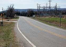
AR 265 begins near Strickler at AR 170 near SEFOR, a deactivated experimental fast breeder reactor.[3] The route continues north as a winding, two-lane highway into Greenland until its junction with I-49 and US 71 in south Fayetteville. The roadway continues north after these intersections (as Arkansas Highway 112) into Fayetteville.
Fayetteville to Springdale

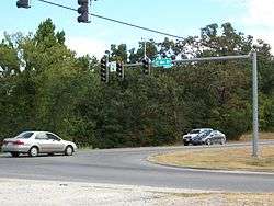
The route begins again at AR 16 in southeast Fayetteville. The highway serves as the entrance to many communities, and is four-lane with center turn lane throughout Fayetteville. AR 265 intersects AR 45, Township Road, Joyce Blvd, Don Tyson Parkway, and US 412 before reaching the Springdale Municipal Airport. The route continues north before ending at AR 264 in Bethel Heights.
Future plans call for it to be extended to AR 94 in Rogers.
Pea Ridge to Missouri
A third segment begins at AR 94 west of Pea Ridge and runs north to the Missouri state line before where it becomes Missouri Route KK.
Major intersections
| County | Location | mi[3][4] | km | Destinations | Notes |
|---|---|---|---|---|---|
| Washington | Strickler | 0.0 | 0.0 | southern terminus | |
| Hogeye | 9.7 | 15.6 | AR 156 western terminus | ||
| Fayetteville | 19.5 | 31.4 | I-49/US 71 concurrency north begins at this interchange | ||
| 19.7 | 31.7 | ||||
| 19.7 | 31.7 | northern terminus | |||
| AR 265 second segment begins in Fayetteville | |||||
| Fayetteville | 0.0 | 0.0 | southern terminus | ||
| 2.4 | 3.9 | ||||
| Springdale | 8.0 | 12.9 | |||
| Benton | 12.0 | 19.3 | northern terminus | ||
| AR 265 northern segment begins in Pea Ridge | |||||
| Pea Ridge | 0.0 | 0.0 | southern terminus | ||
| 3.33 | 5.36 | northern terminus | |||
| 1.000 mi = 1.609 km; 1.000 km = 0.621 mi | |||||
Related routes
Springdale spur
| |
|---|---|
| Location: | Springdale |
| Length: | 2.4 mi (3.9 km) |
Highway 265 Spur was a spur route in Springdale. It was 2.4 miles (3.9 km) in length and was removed from the system in the 1990s, now named Butterfield Coach Road and Emma Avenue.[7]
Highway 383
| |
|---|---|
| Location: | Springdale |
| Length: | 2 mi (3 km) |
Highway 383 was a 2-mile-long (3.2 km) north–south highway along Old Missouri Road in Springdale, Arkansas. Its southern terminus was Highway 68 (now known as U.S. Highway 412) with its northern terminus at Highway 68N (also known as Emma Avenue). It was used primarily as a local access road to nearby Parson's Arena.
In the 1980s, Highway 383 was redesignated as an extension of Highway 265.
References
- 1 2 3 4 "[Arkansas] State Highways 2009 (Database)." April 2010. AHTD: Planning and Research Division. Database. Retrieved March 13, 2011.
- ↑ Route and Section Map - Washington County, Arkansas (PDF) (Map). Arkansas State Highway and Transportation Department. Retrieved March 13, 2011.
- 1 2 3 General Highway Map - Washington County, Arkansas (PDF) (Map) (10/3/08 ed.). Arkansas State Highway and Transportation Department. Retrieved March 13, 2011.
- 1 2 3 General Highway Map - Benton County, Arkansas (PDF) (Map) (8/24/10 ed.). Arkansas State Highway and Transportation Department. Retrieved March 13, 2011.
- ↑ Highway Map of Arkansas (Map) (January 1959 ed.). Arkansas State Highway Department. Archived from the original on March 13, 2012. Retrieved March 13, 2011.
- ↑ 1974 Highway Map of Arkansas (Map) (1974 ed.). Arkansas State Highway Department. Retrieved March 13, 2011.
- ↑ General Highway Map of Washington County, Arkansas (PDF) (Map) (10-14-94 ed.). Arkansas State Highway and Transportation Department. Retrieved March 13, 2011.