Arkansas Highway 269
| ||||
|---|---|---|---|---|
 | ||||
| Route information | ||||
| Maintained by AHTD | ||||
| Length: | 16.94 mi[1] (27.26 km) | |||
| Existed: | July 10, 1957[2] – present | |||
| Major junctions | ||||
| South end: |
| |||
|
| ||||
| North end: |
| |||
| Highway system | ||||
| ||||

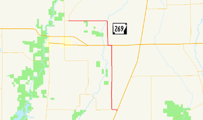
Highway 269 (AR 269, Ark. 269, and Hwy. 269) is a state highway in Woodruff County. The route of 16.94 miles (27.26 km) runs from US Highway 49 (US 49) north to Highway 37. The route is maintained by the Arkansas State Highway and Transportation Department (AHTD).
Route description
The highway begins at US 49 in eastern Woodruff County within the Arkansas Delta between Hillemann and Bemis. The route begins due west to an intersection with the southern terminus of Highway 145 before turning due north and running as a section line road through a rural, agricultural area. Highway 269 crosses the Union Pacific Railroad tracks before meeting US 64. These two routes form a concurrency west for 0.5 miles (0.80 km) until Highway 269 turns north toward Pumpkin Bend. The highway crosses Bayou DeView and turns due west at Pumpkin Bend to terminate at Highway 37 near the Cache River National Wildlife Refuge.[3]
History
Highway 269 was created by the Arkansas State Highway Commission on July 10, 1957 by adding a county road between US 64 at Morton and Pumpkin Bend[a 1] to the state highway system.[2] The highway was extended south from US 64 (along the current alignment) on December 2, 1964, replacing a Highway 39 designation when Highway 39 was moved east onto a new alignment (this Highway 39 designation would later be supplanted by US 49, which remains today).[4]
The route was extended west of Pumpkin Bend on June 23, 1965.[5] The westernmost segment of the highway was rerouted in 1967 onto a new, more direct alignment.[6]
Major intersections
The entire route is in Woodruff County.
| Location | mi[1] | km | Destinations | Notes | |
|---|---|---|---|---|---|
| | 0.00 | 0.00 | Southern terminus | ||
| | 0.75 | 1.21 | AR 145 southern terminus | ||
| Morton | 8.91– 0.00 | 14.34– 0.00 | |||
| | 8.03 | 12.92 | Northern terminus | ||
| 1.000 mi = 1.609 km; 1.000 km = 0.621 mi | |||||
See also
-
 Arkansas portal
 -
 U.S. Roads portal
Notes
- ↑ Minute Order 2233 refers to Pumpkin Bend as "Pumpkin".
References
- 1 2 Planning and Research Division (March 28, 2012). "Arkansas Road Log Database" (MBD). Arkansas State Highway and Transportation Department. Retrieved April 13, 2012.
- 1 2 "Minute Order 2233" (PDF). Minutes of the Meeting. Arkansas State Highway Commission. 1957-07-10. p. 1796. Retrieved 2016-07-09.
- ↑ General Highway Map, Woodruff County, Arkansas (PDF) (Map). 1:62500. Cartography by Transportation Planning & Policy Division. Little Rock: Arkansas State Highway and Transportation Department. 2014-04-03. Retrieved 2016-07-09.
- ↑ "Minute Order 64-411" (PDF). Minutes of the Meeting. Arkansas State Highway Commission. 1964-12-02. pp. 876–877. Retrieved 2016-07-09.
- ↑ "Minute Order 65-182" (PDF). Minutes of the Meeting. Arkansas State Highway Commission. 1965-06-23. pp. 662–664. Retrieved 2016-07-09.
- ↑ "Minute Order 67-347" (PDF). Minutes of the Meeting. Arkansas State Highway Commission. 1967-06-28. p. 345. Retrieved 2016-07-09.
External links
-
 Media related to Arkansas Highway 269 at Wikimedia Commons