Arkansas Highway 306
| ||||
|---|---|---|---|---|
 | ||||
| Route information | ||||
| Maintained by AHTD | ||||
| Existed: | April 24, 1963[1] – present | |||
| Section 1 | ||||
| Length: | 6.65 mi[2] (10.70 km) | |||
| West end: |
| |||
| East end: |
| |||
| Section 2 | ||||
| Length: | 24.27 mi[2] (39.06 km) | |||
| West end: |
| |||
| East end: |
| |||
| Section 3 | ||||
| Length: | 5.98 mi[2] (9.62 km) | |||
| West end: |
| |||
| East end: |
| |||
| Location | ||||
| Counties: | Woodruff, St. Francis, Cross | |||
| Highway system | ||||
| ||||

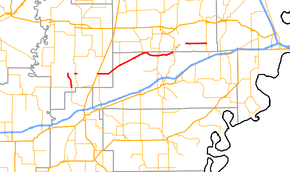
Highway 306 (AR 306, Ark. 306, and Hwy. 306) is a designation for three east–west state highways in the Arkansas Delta. One segment of 6.65 miles (10.70 km) runs from Highway 38 in Cotton Plant north to Woodruff County Road 680 (CR 680) at Becton.[3] A second segment of 24.27 miles (39.06 km) runs northeast from US Route 49 (US 49) in Hunter to Highway 284.[4] The third segment runs 5.98 miles (9.62 km) east from Cross CR 825 at the St. Francis River to Highway 75 at Gieseck.[5]
Route description
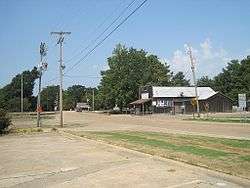
Cotton Plant to Becton
The route begins in Cotton Plant near the eastern terminus of Highway 38 near a junction with Highway 17. Highway 306 runs north through cotton country and the community of Shady Grove until meeting Woodruff CR 762 and CR 780, where state maintenance ends. In an extremely rare circumstance, the highway designation continues along CR 780 in name only as an officially designated exception of 2.24 miles (3.60 km).[a 1] This overlap ceases at a junction with Highway 17 at which Highway 306 begins again and runs for 0.05 miles (0.080 km) before state maintenance ends again. The roadway continues as CR 680.[3]
Hunter to AR 284
Highway 306 begins at the northern town limits of Hunter at US 49. The highway runs east to Holliday before angling northeast and entering St. Francis County.[3] Highway 306 continues northeast, serving as the southern terminus of Highway 259 and passing through the communities of Macedonia and Pine Tree, after which the route begins to curve east. Following an intersection with the southern terminus of Highway 193, the highway intersects Highway 1 in Colt and passes the William Stone House, a property on the National Register of Historic Places.[7] The highway exits Colt heading east and winds through forested areas. The route terminates at Highway 284 near Village Creek State Park and Summer Sweet Lake.[4]
St. Francis River to Gieseck
Highway 306 begins at Cross CR 825, which runs parallel to the St. Francis River levee. The highway runs due east through center pivot irrigation cropland to terminate at Highway 75 at Gieseck, south of Parkin.[5]
History
The road from Hunter east to the St. Francis county line was designated a state highway on April 24, 1963.[1] The Highway 306 segments running north from Cotton Plant and west from Gieseck were added to the state highway system on November 23, 1966.[8]
Major intersections
| County | Location | mi[2] | km | Destinations | Notes | ||
|---|---|---|---|---|---|---|---|
| Woodruff | Cotton Plant | 0.00 | 0.00 | Western terminus | |||
| | 4.36– 6.60 | 7.02– 10.62 | Gap in state maintenance | Officially designated exception over CR 780 | |||
| Becton | 6.60 | 10.62 | |||||
| 6.65 | 10.70 | End state maintenance, eastern terminus | |||||
| Highway 306 begins in Hunter | |||||||
| Hunter | 0.00 | 0.00 | Western terminus | ||||
| | 0.4 | 0.64 | AR 78 northern terminus | ||||
| St. Francis | | 7.25 | 11.67 | AR 259 southern terminus | |||
| | 15.10 | 24.30 | AR 193 southern terminus | ||||
| Colt | 19.52 | 31.41 | |||||
| | 24.27 | 39.06 | Eastern terminus | ||||
| Highway 306 begins near the St. Francis River | |||||||
| Cross | | 0.00 | 0.00 | Western terminus | |||
| Gieseck | 5.98 | 9.62 | Eastern terminus | ||||
| 1.000 mi = 1.609 km; 1.000 km = 0.621 mi | |||||||
See also
-
 Arkansas portal
 -
 U.S. Roads portal
Notes
References
- 1 2 "Minutes of the Meeting" (PDF). Arkansas State Highway Commission. April 24, 1963. p. 919. Retrieved January 28, 2013.
- 1 2 3 4 Planning and Research Division (2010). "Arkansas Road Log Database". Arkansas State Highway and Transportation Department. Archived from the original (Database) on 23 June 2011. Retrieved June 9, 2011.
- 1 2 3 General Highway Map, Woodruff County, Arkansas (PDF) (Map). 1:62500. Cartography by Planning and Research Division. Arkansas State Highway and Transportation Department. September 29, 2000. Retrieved January 28, 2013.
- 1 2 General Highway Map, St. Francis County, Arkansas (PDF) (Map). 1:62500. Cartography by Planning and Research Division. Arkansas State Highway and Transportation Department. August 13, 2008. Retrieved January 28, 2013.
- 1 2 General Highway Map, Cross County, Arkansas (PDF) (Map). 1:62500. Cartography by Planning and Research Division. Arkansas State Highway and Transportation Department. July 11, 2007. Retrieved January 28, 2013.
- ↑ Route and Section Map, Woodruff County, Arkansas (PDF) (Map). 1:62500. Cartography by Planning and Research Division. Arkansas State Highway and Transportation Department. Retrieved January 28, 2013.
- ↑ National Park Service (2010-07-09). "National Register Information System". National Register of Historic Places. National Park Service.
- ↑ "Minutes of the Meeting" (PDF). Arkansas State Highway Commission. November 23, 1966. pp. 558, 569. Retrieved January 28, 2013.