Arkansas Highway 313
| ||||
|---|---|---|---|---|
 | ||||
| Route information | ||||
| Maintained by AHTD | ||||
| Length: | 9.00 mi[1] (14.48 km) | |||
| Existed: | 1965 – present | |||
| Major junctions | ||||
| South end: |
| |||
| North end: |
| |||
| Location | ||||
| Counties: | Lafayette | |||
| Highway system | ||||
| ||||

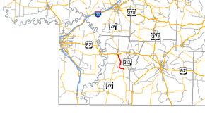
Arkansas Highway 313 is a north–south state highway in Lafayette County. The route runs 9.00 miles (14.48 km) from Arkansas Highway 53 north to Arkansas Highway 29 in Lewisville.[2] The route does not intersect any other state highways.
Route description
Arkansas Highway 313 begins at Arkansas Highway 53 at Mars Hill, an unincorporated community. The route runs north into Lewisville, the county seat of Lafayette County.
The road is a two–lane road for its entire length.
Major intersections
The entire route is in Lafayette County.
| Location | mi[2] | km | Destinations | Notes | |
|---|---|---|---|---|---|
| Mars Hill | 0.0 | 0.0 | Southern terminus | ||
| Lewisville | 9.00 | 14.48 | Northern terminus | ||
| 1.000 mi = 1.609 km; 1.000 km = 0.621 mi | |||||
History
The route was designated a state highway by the Arkansas State Highway Commission on June 23, 1965. The highway follows the original routing.[3]
References
- ↑ Route and Section Map - Lafayette County, Arkansas (PDF) (Map). Arkansas State Highway Department. Retrieved March 21, 2011.
- 1 2 General Highway Map - Lafayette County, Arkansas (PDF) (Map) (6/19/07 ed.). Arkansas State Highway and Transportation Department. Retrieved March 21, 2011.
- ↑ "Minute Order 65-187" (PDF). Minutes of the Meeting. Arkansas State Highway Commission. June 23, 1965. p. 666. Retrieved November 18, 2016.
This article is issued from Wikipedia - version of the 11/18/2016. The text is available under the Creative Commons Attribution/Share Alike but additional terms may apply for the media files.