Armeni (archaeological site)

Armeni is the archaeological site of an ancient Minoan cemetery on Crete.
Geography
The cemetery is eight kilometers south of the modern town of Rethymnon.
Archaeology
Armeni has been under excavation since 1969 by Yiannis Tzedakis. Over 200 chamber tombs and one tholos tomb have been found from the Late Minoan era.
The chambers are approached by dromoi which start at ground level and descend to the entrance of the tomb using a ramp and in some cases steps as well. The walls of the dromoi have been cut in such a way that they are closer to each other at the top than they are at the bottom. The entrances were in most cases originally covered by a large stone, which is usually still to be seen next to the entrance. One or two of the larger tombs have a pillar in the centre of the chamber and in at least one tomb, the walls are lined with stone benches cut from the rock when the tomb was being dug.
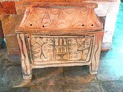
Finds from over 200 chamber tombs included seal stones, jewelry, bronze tools, stone vases, bronze vessels and pottery. Clay larnakes (coffins) painted with double axes, hunting and bull scenes, and Horns of Consecration were also excavated. These artifacts can be found at the Archaeological Museum of Chania and the Rethymno Museum.
Over 500 skeletons have been excavated, yielding useful information about the diet of the Minoan people in this area. They ate high carbohydrate diets but not much meat.
Tourism
Ian Swindale reports that the lighting does not work in many of the tombs, and recommends the use of a flashlight (British: torch). However, there is good lighting in the main rock-cut tomb which lights up automatically when you enter the tomb. The area is open to tourists 8:30 until 15:00, except on Mondays.
References
- Swindale, Ian "Armeni" Retrieved 11 May 2013.
- Myers, J.W., Myers, E.E. and Cadogan, G. "Achladia" The Aerial Atlas of Ancient Crete ISBN 978-0-520-07382-1
External links
| Wikimedia Commons has media related to Necropolis of Armeni. |
- http://www.minoancrete.com/armeni.htm Photos and video of the site. Retrieved 12 May 2013.
Coordinates: 35°19′05.05″N 24°27′48.65″E / 35.3180694°N 24.4635139°E