Arrondissement of Calais
| Calais | |
|---|---|
| Arrondissement of France | |
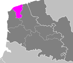 Location of Calais in Nord-Pas-de-Calais | |
| Country | France |
| Region | Hauts-de-France |
| Department | Pas-de-Calais |
| Communes | 28 |
| Subprefecture | Calais |
| Area¹ | |
| • Total | 310 km2 (120 sq mi) |
| Population (2013) | |
| • Total | 118,248 |
| • Density | 380/km2 (990/sq mi) |
| ¹ French Land Register data, which exclude lakes, ponds, and glaciers larger than 1 km² as well as the estuaries of rivers. | |
The Arrondissement of Calais is an arrondissement of France in the Pas-de-Calais department in the Hauts-de-France region. It has 28 communes.
Composition
Cantons
The cantons of the arrondissement of Calais are:
- Calais-1
- Calais-2 (partly)
- Calais-3
- Marck (partly)
Communes
The communes of the arrondissement of Calais, and their INSEE codes, are:
| 1. Alembon (62020) | 2. Andres (62031) | 3. Bonningues-lès-Calais (62156) | 4. Bouquehault (62161) |
| 5. Boursin (62167) | 6. Caffiers (62191) | 7. Calais (62193) | 8. Campagne-lès-Guines (62203) |
| 9. Coquelles (62239) | 10. Coulogne (62244) | 11. Escalles (62307) | 12. Fiennes (62334) |
| 13. Fréthun (62360) | 14. Guînes (62397) | 15. Hames-Boucres (62408) | 16. Hardinghen (62412) |
| 17. Herbinghen (62432) | 18. Hermelinghen (62439) | 19. Hocquinghen (62455) | 20. Les Attaques (62043) |
| 21. Licques (62506) | 22. Marck (62548) | 23. Nielles-lès-Calais (62615) | 24. Peuplingues (62654) |
| 25. Pihen-lès-Guînes (62657) | 26. Saint-Tricat (62769) | 27. Sangatte (62774) | 28. Sanghen (62775) |
External links
Coordinates: 50°57′N 1°51′E / 50.950°N 1.850°E
This article is issued from Wikipedia - version of the 11/18/2016. The text is available under the Creative Commons Attribution/Share Alike but additional terms may apply for the media files.