Asō Bay
| Asō Bay 浅茅湾 | |
|---|---|
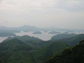 Asō Bay, Tsushima | |
| Coordinates | 34°20′24″N 129°15′3″E / 34.34000°N 129.25083°ECoordinates: 34°20′24″N 129°15′3″E / 34.34000°N 129.25083°E |
| Basin countries | Japan |
| Max. width | 4.18 km (at mouth) |
| Surface area | 58 km2 (22 sq mi) |
| Max. depth | 80 m (260 ft) |
| Settlements | Tsushima, Nagasaki Prefecture |
Asō Bay (浅茅湾 Asō-wan) is a deep fjord that nearly cleaves in two the Japanese island of Tsushima. The bay is notable for its ria coastline, with various small islands found in close proximity to the shore.[1] It forms part of the Iki-Tsushima Quasi-National Park.[2] Pearls are cultured and Japanese amberjack are farmed in its waters.[3]
Manzeki Channel
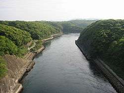
Manzeki Channel (万関瀬戸 Manzeki seto)
The Manzeki Channel (万関瀬戸) links Asō Bay with Miura Bay (三浦湾), which opens onto the Tsushima Straits. The channel was cut by the Imperial Japanese Navy between 1895 and 1904. Initially twenty-five metres across and three metres deep, it was later enlarged to accommodate bigger vessels.[4]
References
- ↑ Rowlett, Russ. "Lighthouses of Japan: Tsushima". The Lighthouse Directory. University of North Carolina at Chapel Hill.
- ↑ "A Profile of Tsushima shi (Tsushima City)". Tsushima City. Retrieved 15 February 2012.
- ↑ "浅茅湾". Ministry of the Environment. Retrieved 15 February 2012.
- ↑ Nicol, C. W. (7 March 2010). "Hark ye to the Donkey's Ears". The Japan Times. Retrieved 15 February 2012.
This article is issued from Wikipedia - version of the 1/10/2015. The text is available under the Creative Commons Attribution/Share Alike but additional terms may apply for the media files.