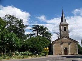
Ayguetinte
| Ayguetinte | |
|---|---|
 | |
 Ayguetinte | |
|
Location within Occitanie region  Ayguetinte | |
| Coordinates: 43°50′06″N 0°25′41″E / 43.835°N 0.4281°ECoordinates: 43°50′06″N 0°25′41″E / 43.835°N 0.4281°E | |
| Country | France |
| Region | Occitanie |
| Department | Gers |
| Arrondissement | Condom |
| Canton | Valence-sur-Baïse |
| Intercommunality | Cœur de Gascogne |
| Government | |
| • Mayor (2008–2014) | Francis Ballérini |
| Area1 | 6.31 km2 (2.44 sq mi) |
| Population (2008)2 | 180 |
| • Density | 29/km2 (74/sq mi) |
| Time zone | CET (UTC+1) |
| • Summer (DST) | CEST (UTC+2) |
| INSEE/Postal code | 32024 / 32410 |
| Elevation |
96–203 m (315–666 ft) (avg. 113 m or 371 ft) |
|
1 French Land Register data, which excludes lakes, ponds, glaciers > 1 km² (0.386 sq mi or 247 acres) and river estuaries. 2 Population without double counting: residents of multiple communes (e.g., students and military personnel) only counted once. | |
Ayguetinte (Aigatinta (colored water) in Occitan language) is a commune in the Gers department in southwestern France.
Geography
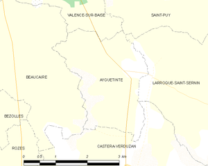
Ayguetinte and its surrounding communes
Population
| Historical population | ||
|---|---|---|
| Year | Pop. | ±% |
| 1962 | 222 | — |
| 1968 | 199 | −10.4% |
| 1975 | 173 | −13.1% |
| 1982 | 172 | −0.6% |
| 1990 | 162 | −5.8% |
| 1999 | 152 | −6.2% |
| 2008 | 180 | +18.4% |
See also
References
| Wikimedia Commons has media related to Ayguetinte. |
This article is issued from Wikipedia - version of the 2/11/2016. The text is available under the Creative Commons Attribution/Share Alike but additional terms may apply for the media files.