Bachtel
This article is about the mountain. For the ship on Lake Zurich, see Bachtel (ship, 1962).
| Bachtel | |
|---|---|
 View from the summit | |
| Highest point | |
| Elevation | 1,115 m (3,658 ft) |
| Prominence | 358 m (1,175 ft) [1] |
| Parent peak | Tweralpspitz |
| Coordinates | 47°17′41″N 8°53′11″E / 47.29472°N 8.88639°ECoordinates: 47°17′41″N 8°53′11″E / 47.29472°N 8.88639°E |
| Geography | |
 Bachtel Location in Switzerland | |
| Location | Zurich, Switzerland |
| Parent range | Eastern Swiss Prealps |
| Climbing | |
| Easiest route | Road |
Bachtel is a mountain of the Zurich Upperland, Swiss Prealps, located between Hinwil and Wald in the canton of Zurich. It lies approximately halfway between the Schnebelhorn (the highest point of the canton) and Lake Zurich.
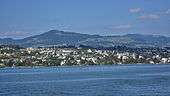
Bachtel mountain and Kempraten as seen from Zürichsee-Schifffahrtsgesellschaft (ZSG) ship MS Helvetia on Zürichsee
On the summit is the Bachtel Tower, a 60 metres (200 ft) tall radio tower.
References
External links
This article is issued from Wikipedia - version of the 11/19/2016. The text is available under the Creative Commons Attribution/Share Alike but additional terms may apply for the media files.