Bad Rippoldsau-Schapbach
| Bad Rippoldsau-Schapbach | ||
|---|---|---|
 | ||
| ||
 Bad Rippoldsau-Schapbach | ||
| Coordinates: 48°22′38″N 8°17′31″E / 48.37722°N 8.29194°ECoordinates: 48°22′38″N 8°17′31″E / 48.37722°N 8.29194°E | ||
| Country | Germany | |
| State | Baden-Württemberg | |
| Admin. region | Karlsruhe | |
| District | Freudenstadt | |
| Government | ||
| • Mayor | Bernhard Waidele (CDU) | |
| Area | ||
| • Total | 73.14 km2 (28.24 sq mi) | |
| Population (2015-12-31)[1] | ||
| • Total | 2,121 | |
| • Density | 29/km2 (75/sq mi) | |
| Time zone | CET/CEST (UTC+1/+2) | |
| Postal codes | 77776 | |
| Dialling codes | 07440, 07839 | |
| Vehicle registration | FDS; bis 1973: WOL | |
| Website | www.bad-rippoldsau-schapbach.de | |

Bad Rippoldsau-Schapbach is a municipality in the district of Freudenstadt in Baden-Württemberg in southern Germany.
Geography
The Municipality is located in the black forest in the Wolftal valley, 15 km away from Freudenstadt. The Municipality is divided into two villages, Bad Rippoldsau and Schapbach. Bad Rippoldsau has an elevation of 560 meters and Schapbach has an elevation of 410 meters.
History
The first historical mention of Bad Rippoldsau was in 1179, of Schapbach in 1220. Until 1974 the two villages were two municipalities, but then they became one. Since the 15th century there has been a spa in Bad Rippoldsau.
Sights
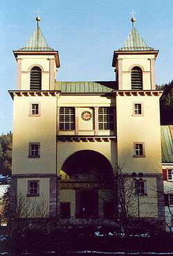
- The Catholic pilgrimage church of Bad Rippoldsau, which was built in 1829 by Christoph Arnold, a pupil of Friedrich Weinbrenner.
- The baroque church of Schapbach
- The Kastelstein, a rock near Bad Rippoldsau.
- The Glaswaldsee, a cirque lake which was formed by glaciers during the last ice age
- The Burgbachwasserfall, at 32 meters one of the highest free-falling cascades in Germany
- NEW! since September 2010 is a wildlife park with bears and wolves! This spot is located btw. the villages of Schapbach and Bad Rippoldsau - http://baer.de/
Sports and recreation facilities
- The spa of Bad Rippoldsau
- The open air bath in Schapbach
Government
The current mayor of the municipality is Bernhard Waidele.
Personality
- George Michael Gaisser (1595–1655), Prior in St. Nicholas and Lord in Klosterbad Rippoldsau during the Thirty Years' War
- Christian Haldenwang (1770–1831), artist and engraver, buried in Bad Rippoldsau
- Christoph Arnold (1779–1844), architect, builder of Rippoldsau Catholic Church
- Joseph Victor von Scheffel (1826–1886), writer, poet of The emergence of Rippoldsau or the story of brother Rippold and The Sweden in Rippoldsau
- Heinrich Hans Jacob (1837–1916), writer, author of numerous stories about the Wolf valley
- Marc Rosenberg (1852–1930), art historian, philologist and collector, owner of the "Schlössle" on the Schmiedsberg in Schapbach where parts of his collections were housed.[2]
- Otto Goeringer (1853–1920), the hotel owner and operator of the spa
- Rainer Maria Rilke (1875–1926), poet, spa guest in Bad Rippoldsau
- Otto Kuner (1879–1953), lawyer and politician (BCSV, CDU) was born in Bad Rippoldsau
- Anna Schmid (1928–2010), long-time head of Rippoldsauer old plant, holder of the Federal Order of Merit
- Adolf J. Schmid (1934–2011), historian, local historian, author of several chronicles the upper Wolf valley, honorary citizen of
- Chris Weller (born 1957), musician and composer, grew up in Schapbach
- Ralf Bernd flocks (born 1960), Lawyer, lecturer, writer, historian, mayor from 1991 to 2007
- Wolfram Lotz (born 1981), known playwright, grew up in Bad Rippoldsau
References
- ↑ "Gemeinden in Deutschland nach Fläche, Bevölkerung und Postleitzahl am 30.09.2016". Statistisches Bundesamt (in German). 2016.
- ↑ Hermann Fautz: The Schlößle on Schmiedsberg. In: The Ortenau 1970 330-333
Towns and municipalities in Freudenstadt (district) | ||
|---|---|---|