Turlock Municipal Airport
| Turlock Municipal Airport Ballico Air Force Auxiliary Field | |||||||||||
|---|---|---|---|---|---|---|---|---|---|---|---|
|
2006 USGS airphoto | |||||||||||
| IATA: none – ICAO: none – FAA LID: O15 | |||||||||||
| Summary | |||||||||||
| Airport type | Public | ||||||||||
| Operator | City of Turlock | ||||||||||
| Location | Turlock, California | ||||||||||
| Elevation AMSL | 159 ft / 48.5 m | ||||||||||
| Coordinates | 37°29′15″N 120°41′49″W / 37.48750°N 120.69694°WCoordinates: 37°29′15″N 120°41′49″W / 37.48750°N 120.69694°W | ||||||||||
| Map | |||||||||||
 O15 Location of Turlock Municipal Airport | |||||||||||
| Runways | |||||||||||
| |||||||||||
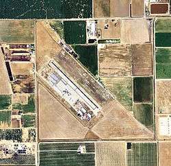
Turlock Municipal Airport (FAA LID: O15) is a public airport located eight miles (13 km) east of Turlock, serving Stanislaus County, California, USA. This general aviation airport covers 320 acres (129 ha) and has one runway.
World War II
During World War II, the airport was designated as Ballico Air Force Auxiliary Field, and was an auxiliary training airfield for Merced Army Airfield, California.
See also
References
![]() This article incorporates public domain material from the Air Force Historical Research Agency website http://www.afhra.af.mil/.
This article incorporates public domain material from the Air Force Historical Research Agency website http://www.afhra.af.mil/.
External links
- Resources for this airport:
- FAA airport information for O15
- AirNav airport information for O15
- FlightAware airport information and live flight tracker
- SkyVector aeronautical chart for O15
| Flying Training |
|  | ||||||
|---|---|---|---|---|---|---|---|---|
| Technical Training |
| |||||||
This article is issued from Wikipedia - version of the 12/14/2014. The text is available under the Creative Commons Attribution/Share Alike but additional terms may apply for the media files.