Ballynegall House
Ballynegall House (sometimes spelled "Ballynagall") was a large country house in County Westmeath, Ireland. In Irish Baile na nGall translates to “The Town of the Foreigners” which may be a reference to the Anglo-Norman invaders who occupied the area[1]
Its gutting and fall into ruins was said to be one of great architectural losses in Ireland.[2]
Creation and country house
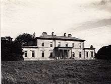
The house was built between around 1808 and was considered one of the finest regency houses in Westmeath. It was built by Francis Johnston, one of the most famous architects of his day who was also responsible for the General Post Office and the Irish Houses of Parliament, now the Bank of Ireland building in College Green both in Dublin.
It was originally built for James Gibbons and remained in the Gibbons name until 1846.[3] It then passed by marriage to the Smyth family where it remained until the early 1960s.
Fall into ruins
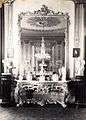
The last owner Michael Hawkesworth Smyth sold the house with several hundred acres of good farming land for about £12,000 (even then a small amount). It changed hands until in 1981 many of the fine architectural pieces were gutted and sold (the fireplace alone was reported sold for £6,000) the house became a ruin. Many of the items from the house are still in existence today in other buildings: the fine portico found a new home at the entrance to the K Club, Straffan, County Kildare, and the Turner conservatory at the La Serre restaurant on the Lyons estate, Celbridge, County Kildare.[4]
-
-

The fireplace was ripped out and reportedly sold for approximately half the value the whole estate was originally sold for
-
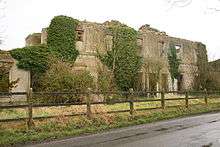
Ballynagall House in 2008
References
- ↑ "The Life Story of Marjorie Ferard née Smyth" (PDF). http://www.ferard.co.uk/. Retrieved 11 November 2014. External link in
|website=(help) - ↑ "The National Inventory of Architectural Heritage". The National Inventory of Architectural Heritage. Retrieved 11 November 2014.
- ↑ "Lord Belmont In Northern Ireland". lordbelmontinnorthernireland.blogspot.co.uk. Retrieved 11 November 2014.
- ↑ "westmeathexaminer". westmeathexaminer. westmeathexaminer. Retrieved 11 November 2014.
Coordinates: 53°34′39″N 7°20′03″W / 53.5775°N 7.3342°W