Bananal Island
| Native name: <span class="nickname" ">Ilha do Bananal | |
|---|---|
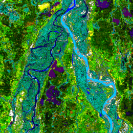 Landsat image of the northern end of Rio das Mortes-Cristalino peninsula adjoint southwest to Bananal Island by Araguaia river | |
 Bananal Location in Brazil | |
| Geography | |
| Location | State of Tocantins, Brazil |
| Coordinates | 11°20′S 50°41′W / 11.333°S 50.683°W |
| Area | 19,162.25 km2 (7,398.59 sq mi) |
| Area rank | 49th |
| Administration | |
|
Brazil | |
| State | Tocantins |
| Additional information | |
| Designated | 4 October 1993 [1] |
Bananal Island (Portuguese: Ilha do Bananal, IPA: [banaˈnaw]) is a large river island formed from the bisection of the Araguaia River, in southwestern Tocantins, Brazil. The island is formed by a fork in a very flat section of the Araguaia River. Bananal Island is the second largest fluvial island in the world and the largest without an ocean coastline, at 350 kilometres (220 mi) long and 55 kilometres (34 mi) wide.[2] Its total area is 19,162.25 square kilometres (7,398.59 sq mi).[3]
Environmental and cultural protection
Bananal Island is a nature and culture preserve. In accordance with Article 28 of the Statute of Indian Law (Artigo 28 do Estatuto do Indío-lei) No. 6001 laid out on 19 December 1973, an area of 5,577.26 square kilometres (2,153.39 sq mi) is preserved as Araguaia National Park and further 13,584.99 square kilometres (5,245.19 sq mi) as cultural preserve for indigenous peoples. The northern third of the island, which is designated as a national park, is a popular destination for ecotourism. The southern two-thirds are indigenous territories.
Inhabitants
Although Brazilians of non-native descent lived on the island in the past, today only natives populate the island.
At least four tribes live on Bananal Island: the Javaés, Karajá, Ava-Canoeiro, and Tuxá. There are sixteen aldeias or villages on the island: Barra do Rio, Barreira Branca, Boa Esperança, Boto Velho, Cachoeirinha, Fontoura, JK, Kanoanã, Kaxiwe, Macaúba, Santa Isabel, São João, Txoude, Txuiri, Wari-Wari, Watau.
There are no bridges to the island from the states of Tocantins to the east nor from Mato Grosso to the west. For the greater majority of the year, the only transport to the island is by boat. However, for a few weeks during the dry season (June - August) the river is low enough that the island can be reached by car. The villages have roads wide enough for cars and tractors even though the main forms of transport are by horse, bicycle, and foot.
Municipalities
From north to south, the island forms the western portions of the municipalities of Pium, Lagoa da Confusão, and Formoso do Araguaia, in southwestern Tocantins.
References
- ↑ "Ramsar List". Ramsar.org. Archived from the original on 9 April 2013. Retrieved 15 April 2013.
- ↑ Island Superlatives
- ↑ "Bananal Island". Encyclopaedia Britannica. Encyclopaedia Britannica Inc. 2015. Retrieved 2015-07-28.
Coordinates: 11°20′S 50°41′W / 11.333°S 50.683°W