Bangda Lake
| Banda Lake | |
|---|---|
| Location | Rutog County, Ngari Prefecture, Tibet Autonomous Region, China |
| Coordinates | 34°56′56″N 81°34′16″E / 34.94889°N 81.57111°ECoordinates: 34°56′56″N 81°34′16″E / 34.94889°N 81.57111°E |
| Catchment area | 3,314.5 km2 (1,300 sq mi) |
| Basin countries | China |
| Max. length | 15 km (9 mi) |
| Max. width | 9.7 km (6 mi) |
| Surface area | 106.5 km2 (0 sq mi) |
| Surface elevation | 4,902 m (16,083 ft) |
| References | [1] |
Bangda Lake (Tibetan: པང་བཏགས་མཚོ, Wylie: pang btags mtsho ; Chinese: 邦达错; pinyin: Bāngdá Cuò), also Bangdag or Bangdacuo, is a glacial lake in Ngari Prefecture in the northwest of the Tibet Autonomous Region of China. It lies in the western Kunlun Mountains, to the southeast of Guozha Lake.[2] Located at an altitude of 4902 metres, it covers an area of 106 square kilometres with a maximum depth of 21.6 metres and contains 90 glaciers.[3]
References
- ↑ Sumin, Wang; Hongshen, Dou (1998). Lakes in China. Beijing: Science Press. p. 416. ISBN 7-03-006706-1.
- ↑ Maps (Map). Google Maps.
- ↑ Glacial and lake fluctuations in the area of the west Kunlun Mountains during the last 45000 years (PDF). Annals of Glaciology, International Glacial Society. Volume 16, 1992. pp. 79–84. Retrieved 9 April 2012. Check date values in:
|date=(help)
| County-level divisions | 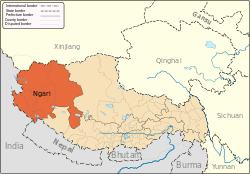 | |
|---|---|---|
| Towns and villages | ||
| Geography | ||
| Landmarks | ||
This article is issued from Wikipedia - version of the 8/14/2014. The text is available under the Creative Commons Attribution/Share Alike but additional terms may apply for the media files.