Bankhead Highway
| |
|---|---|
| Route information | |
| Existed: | 1916 – present |
| Major junctions | |
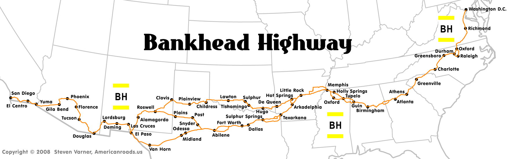
| West end: | Corners of 5th and Broadway in San Diego, CA |
| East end: | Zero Milestone in Washington, D.C. |
| Highway system | |

The Bankhead Highway was a United States cross-country automobile highway connecting Washington, D.C. and San Diego. It was part of the National Auto Trail system. The road was named for Alabama politician John Hollis Bankhead, a leader in the early national road building movement. In later years, several stretches of U.S. Route 78 in northwest Alabama were renamed for Bankhead's son, former U.S. Representative and Speaker of the House William B. Bankhead.
Route description

As was common with early auto trails, the Bankhead Highway had several different routes. The main and branch routes below are considered to be the primary configurations of the highway.
District of Columbia
The route began in Washington, D.C., following US 1 into Virginia.
Virginia
In Virginia, the route followed US 1 through Fredericksburg and Richmond. At South Hill the route turned southwest onto US 58 and followed it to Clarksville, where it turned south onto US 15 and continued into North Carolina.
North Carolina
The route entered North Carolina on US 15 and followed it into Durham before taking the route of US 70 to Greensboro. At Greensboro, the Bankhead Highway took the current route of US 29 through Charlotte.
South Carolina
US 29 passes through the South Carolina city of Greenville on Wade Hampton Boulevard and Church Street.
Georgia
The Bankhead Highway followed present day US 29, which traverses the northern half of Georgia on mostly its original alignment until it reaches Athens, where major highway construction in the 1960s re-routed the route of US 29 around the Athens loop highway. Along this stretch there are numerous "Old US 29" segments that pull off the main roadway. The Bankhead Highway then pulled off the current route of US 29 at Danielsville Road, and followed it until it became North Avenue, and followed North Avenue onto West Dougherty Street. It followed West Dougherty Street, turning South onto Pulaski St, and then turning West onto Broad Street, which eventually turns into Atlanta Highway.[1] While US 29 now follows the route of State Route 316 (University Parkway) for much of the distance between Athens and Lawrenceville, the Bankhead route followed Atlanta Highway to the present US 29 Business (Winder Highway out of Lawrenceville) and Atlanta Highway out of Athens) and went through the smaller towns of Bogart and Winder until joining back up with current US 29 outside of Lawrenceville, where it followed the current alignment of US 29 through Lawrenceville and on to Decatur. The Bankhead Highway (older US 29 alignment) veered onto Church Street (Georgia SR 8) and following it until it intersected Ponce De Leon Avenue.[2] The route then headed west and following Ponce De Leon Avenue into Atlanta the intersection with Peachtree Street, where the route turned South one block to North Avenue, then followed North Avenue to Marietta Street. Following Marietta Street, it veered off to the west where a bridge (now closed but still standing) carried the highway over Georgia Southern Railroad tracks to the present Donald Lee Hollowell Parkway.[3] From the intersection of Northside Drive and Donald Lee Hollowell Parkway west, the route roughly followed US 78 to the Alabama state line.
Many Georgia cities along the original route have streets named Bankhead which mark the actual route. One notable exception to this rule is the Donald Lee Hollowell Parkway in the Bankhead neighborhood of Atlanta. This section was renamed in an effort to revitalize, or mask the social stigma attached to this high-crime section of the city. The same was done in the adjacent section west of the Chattahoochee River by the Cobb county commission, which named it Veterans Memorial Parkway through Mableton and Austell.
Alabama
From Atlanta, the highway took the route of US-78 westward through Birmingham, and into Mississippi.
Mississippi
North branch from Guin Tremont, Clay, Fulton, Mooreville, Tupelo (branches merge).
South branch from Guin Splunge, Hatley, Amory, Bigbee, Nettleton, Maring, Plantersville, Tupelo (branches merge).
North branch from Tupelo Sherman, Blue Springs, Wallerville, New Albany, Myrtle, Hickory Flat, Winborn, Waits, Holly Springs, Red Banks, Victoria, Byhalia, Miller, Olive Branch (branches merge).
South branch from Tupelo Bissell, Furrs, Pontotoc, Springville, Toccopola, Oxford (A branch of the BH may link Oxford to Holly Spings on the north branch. Towns include College Hill, Abbeville, Malone, Waterford, Gilton, Holly Springs), Tyro, Independence, Lewisburg, Cedarview, Olive Branch (branches merge).
Tennessee
Bankhead's route entered Tennessee at Memphis. In Memphis, the route left US-78 and followed US-70 into Arkansas.
Arkansas
The route passed through Little Rock on US 70. At Hot Springs, travelers were given two options (alternate routes were common on auto trails).
Main Route
The main route followed Arkansas Highway 7 to US 67 at Arkadelphia, and followed US 67 to Texarkana and into Texas.
Branch Route
The branch route followed US 70 from Hot Springs to Oklahoma.
Oklahoma
Branch Route
In Oklahoma, the branch route followed US 70 to US 81 to Oklahoma State Highway 7 in rural parts of the state. State Highway 7 connects to US 62 at Lawton, and the route followed US 62 to Texas.
Texas

On Friday, June 19, 2009, the Bankhead Highway was designated a Texas Historic Highway as part of the new state Historic Roads and Highways Program. This measure was introduced by State Representative Carol Kent (District 102, Dallas County). The purpose of this designation is to supplement the Texas Historical Commission's existing "heritage tourism" programs and to increase interest in the Bankhead Highway.
"The Bankhead is a vital part of our state's history, and it is in danger of being forgotten," said Rep. Kent who recently completed her first legislative session representing North Dallas, Richardson, and Garland. "With the passage of this law, we can celebrate this part of our Texas heritage, and also promote the Bankhead as a tool for economic development in towns and cities across our state."
Main Route
The primary route through Texas was originally Texas Highway No.1, which became part of U.S. Route 67 and U.S. Route 80. The main route passed through Texarkana and Garland before arriving at Fort Worth where it turned onto former U.S. Route 80. The route, like the former US 80, went through the smaller cities of Midland and Odessa before rejoining the branch route at El Paso. The route from Fort Worth to El Paso is now followed by I-20 and I-10.
Branch Route (also includes New Mexico)
The branch route entered Texas on US 62, then turned onto US 70 at Paducah. The route went through eastern New Mexico, first at Clovis then through Roswell before turning onto US 54 at Alamogordo and reentering Texas at El Paso. The branch route rejoined the main one at El Paso.
Third Route
A third route connected the main and branch routes in western Texas and eastern New Mexico. This route followed the current US 84 to Post, where it turned westward on the current US 380 to Roswell, New Mexico.
New Mexico
(For details on the branch routes in New Mexico, see branch route and third route entries for Texas/New Mexico).
In New Mexico, the Bankhead route followed the former US 80 (now I-10 through Las Cruces and into Arizona.
Arizona
In Arizona, the route continued to Tucson, where it took Arizona State Route 77 to Arizona State Route 79, which it followed north to US 60, then west to Mesa, Tempe, and Phoenix on Van Buren Street. The route followed the former US 80 through smaller towns on the west side of Phoenix and south to Gila Bend. US 80 closely followed the route of I-8 into California.
California
The route followed the former US 80 in California through El Centro, El Cajon, La Mesa, and into San Diego, the highway's western terminus. This section of the Bankhead Highway is now a California state historic highway.[4]
Signage
The Bankhead Highway was marked by a pole marker that was white with yellow stripes on the top and bottom and the letters "BH" in black.
See also
-
 U.S. Roads portal
References
- ↑ "GDOT 1966 Highway Map, Athens Inset" (PDF). Retrieved June 24, 2016.
- ↑ "GDOT County Map Archives DeKalb 1948, 1965 Maps". Retrieved June 24, 2016.
- ↑ "GDOT Map Archive 1940 System Map, Atlanta Inset" (PDF). Georgia Department of Transportation. Retrieved June 24, 2016.
- ↑ California State Legislature. "ACR 123 Assembly Concurrent Resolution." Official California Legislative Information. Legislative Council of California. August 16, 2006. Retrieved March 23, 2008.
External links
- Bankhead Highway at AmericanRoads.us
- Route Map at Americanroads.us
- Bankhead Highway entry in History of Alabama at AmericanRoads.us
- Zero Milestone - Washington, DC at Federal Highway Administration
- Bankhead Highway on Texas Time Travel
- Bankhead Highway on Texas Historical Commission