Barton-le-Street
| Barton-le-Street | |
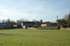 Village green at Barton-le-Street |
|
 Barton-le-Street |
|
| Population | 170 |
|---|---|
| OS grid reference | SE721742 |
| Civil parish | Barton-le-Street |
| District | Ryedale |
| Shire county | North Yorkshire |
| Region | Yorkshire and the Humber |
| Country | England |
| Sovereign state | United Kingdom |
| Post town | MALTON |
| Postcode district | YO17 |
| Police | North Yorkshire |
| Fire | North Yorkshire |
| Ambulance | Yorkshire |
| EU Parliament | Yorkshire and the Humber |
| UK Parliament | Thirsk and Malton (formerly Ryedale) |
Coordinates: 54°09′34″N 0°53′46″W / 54.15940°N 0.89605°W
Barton-le-Street is a village and civil parish in the Ryedale district of North Yorkshire, England. According to the 2001 census the parish had a population of 186 reducing to 170 at the 2011 Census.[1] It is located about five miles west of Malton, between Appleton-le-Street and Slingsby on the old Roman road which is now the B1257.
History
The village is recorded as Bartun in the Domesday Book.[2] It lay within the Maneshou Hundred and was in the possession of the King having previously been owned by Earl Morcar. The village name is Anglo-Saxon and derived from bere, meaning barley and tun meaning settlement.[3] The suffix of "le-Street" denotes that it was situated on an old Roman road.[4]
Governance
The village lies within the Thirsk and Malton parliamentary constituency. It is also in the Hovingham ward of Ryedale District Council. It is within the Hovingham and Sheriff Hutton electoral division of North Yorkshire County Council.[5]
The Civil Parish also includes the hamlet of Butterwick. According to the 2001 UK census the parish population was 186. There are 82 dwellings of which all but one were occupied. Of the total population, 158 were over 16 years old of which 92 were in employment.[6]
Geography
The village lies 5.5 miles (8.9 km) west of Malton on the B1257 between Appleton-le-Street to the east and Slingsby to the west. The area is made of undulating hills on limetsone bedrock covered by clay.[4] It is surrounding by farmland, mostly for crop growing. The village used to have a station on the Thirsk and Malton Line used to pass through the village and the Old Station buildings, now the Village Hall, can be found on the north side on the road to Butterwick.[4] The village is served by the Malton to Helmsley bus service.[7]
Education
There is no longer a school in the village and the nearest Primary education is to be found at Amotherby Community Primary School or Slinsgby Community Primary School. Secondary education is provided at Malton School.[8]
Religion
The present church of St Michael and All Angels was re-built in 1871 on the same site of the previous Norman church believed to have been built around 1160.[4][9]
Gallery
| Views of Barton-le-Street | ||||
|---|---|---|---|---|
|
.jpg)

References
- ↑ "Parish population 2011". Retrieved 11 August 2011.
- ↑ Ekwall, Eilert, The Concise Oxford Dictionary of English Place-Names. Oxford, Oxford University Press, 4th edition, 1960. p. 29. ISBN 0198691033.
- ↑ "Etymology". Retrieved 10 November 2012.
- 1 2 3 4 Bulmer's Topography, History and Directory (Private and Commercial) of North Yorkshire 1890. S&N Publishing. 1890. p. 645. ISBN 1-86150-299-0.
- ↑ Ordnance Survey Open Viewer
- ↑ "2001 UK Census Statistics". Retrieved 10 November 2012.
- ↑ "Public Transport". Retrieved 10 November 2012.
- ↑ "Schools". Archived from the original on 9 November 2012. Retrieved 10 November 2012.
- ↑ "The Street Parishes". Retrieved 10 November 2012.
External links
| Wikimedia Commons has media related to Barton-le-Street, North Yorkshire. |
- The geographic coordinates are from the Ordnance Survey.
- Barton [le Street] in the Domesday Book