Baruntse
| Baruntse | |
|---|---|
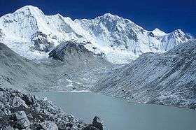 Baruntse from Hongu Valley | |
| Highest point | |
| Elevation | 7,162 m (23,497 ft) [1] |
| Prominence | 979 m (3,212 ft) [1] |
| Coordinates | 27°52′17.86″N 86°58′48.47″E / 27.8716278°N 86.9801306°ECoordinates: 27°52′17.86″N 86°58′48.47″E / 27.8716278°N 86.9801306°E |
| Geography | |
 Baruntse Nepal | |
| Location | Khumbu, Nepal |
| Parent range | Himalayas |
| Climbing | |
| First ascent | 1954 by New Zealand expedition |
| Easiest route | glacier/snow/ice climb |
Baruntse is a mountain in the Khumbu region of eastern Nepal, crowned by four peaks and bounded on the south by the Hunku Glacier, on the east by the Barun Glacier, and on the northwest by the Imja Glacier. The mountain was first climbed May 30, 1954 via the south ridge by Colin Todd and Geoff Harrow of a New Zealand expedition led by Sir Edmund Hillary.[2]
Accessing the mountain is usually gained from the South, where climbers can ascend Mera Peak to acclimatise before moving up the valley to Baruntse base camp.
It is recorded that 19-time M. Everest summiter Chhewang Nima died in 2010 on an expedition to Baruntse.[3] He was hit by an avalanche at an altitude of about 7 km (23,114 feet) above sea level.[3]
References
- 1 2 "Baruntse, Nepal" Peakbagger.com. Retrieved 2012-01-22.
- ↑ Hillary, E.; Hardie, N.; Harrow, G.; Ball, M.; Todd, C. (1955). "The N.Z.A.C. Himalayan Expedition, 1954". New Zealand Alpine Journal: 5–53. Archived from the original on February 18, 2013. Retrieved November 25, 2012.
- 1 2 "Search for missing Nepal Sherpa Chhewang Nima stopped". BBC News. Retrieved 1 September 2015.
This article is issued from Wikipedia - version of the 10/27/2016. The text is available under the Creative Commons Attribution/Share Alike but additional terms may apply for the media files.