Batenburg
| Batenburg | |
|---|---|
| Map - NL - Wijchen - Wijk 03 Batenburg - Buurt 00 Batenburg.svg | |
| Coordinates: 51°49′24″N 5°37′40″E / 51.82333°N 5.62778°E | |
| Country | Netherlands |
| Province | Gelderland |
| Municipality | Wijchen |
| Population | ca. 600 |
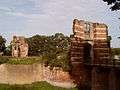
Batenburg is a village in the municipality of Wijchen, in the Dutch province of Gelderland. It is located on the Meuse, about 15 km west of Nijmegen. It is well known for the remains of a medieval fort in the center of the town. The town gained cityrights in the 14th century, although it only has a population of about 650 today
Until 1984, Batenburg was a separate municipality.
Gallery
-

Batenburg, church: de Sint Victorkerk
-

Batenburg gevelsteen, Prinsengracht, Amsterdam

External links
- J. Kuyper, Gemeente Atlas van Nederland, 1865-1870, "Batenburg". Map of the former municipality, around 1868.
Coordinates: 51°49′N 5°38′E / 51.817°N 5.633°E
This article is issued from Wikipedia - version of the 2/15/2016. The text is available under the Creative Commons Attribution/Share Alike but additional terms may apply for the media files.